Ontario Highway 64
King's Highway 64, commonly referred to as Highway 64, is a provincially maintained highway in the Canadian province of Ontario, connecting Highway 69 north of the French River with Highway 11 at Marten River, via Highway 17 west of Sturgeon Falls. The route serves several communities along the north shore of the French River and west shore of Lake Nipissing as it travels from Highway 69 to Highway 17. North of Sturgeon Falls, the highway provides a shortcut between Highway 17 and Highway 11 northwest of North Bay.
| ||||
|---|---|---|---|---|
| Route information | ||||
| Maintained by Ministry of Transportation of Ontario | ||||
| Length | 145.0 km[1] (90.1 mi) | |||
| Existed | August 25, 1937[2]–present | |||
| Major junctions | ||||
| South end | ||||
| North end | ||||
| Highway system | ||||
| ||||
Highway 64 was first assumed in 1937, the year that the Ontario Department of Highways (DHO) merged with the Department of Northern Development (DND) and began assigning route numbers in northern Ontario. It initially connected only Highway 17 and Highway 11, as Highway 69 was not completed through French River until after World War II. In 1956, the route was extended southwest to Rutter via Noëlville to meet Highway 69, establishing the route as it exists today.
Route description
The southern terminus of Highway 64 is an interchange with Highway 69 in Sudbury District at Rutter. Formerly a grade-level intersection, this terminus was upgraded to a full interchange which officially opened in 2016, as part of the ongoing freeway conversion of Highway 69.[3] West of the interchange, the roadway continues as Daoust Lake Road.
The highway travels east for approximately 26 kilometres (16 mi), where it intersects with Highway 528. At that intersection, Highway 528 continues east, while Highway 64 turns north for four kilometres to Noëlville, where it intersects with Highway 535. Highway 535 continues north, while Highway 64 heads east again for six kilometres to the community of Chartrand Corner.[4]
The highway continues, alternating in northward and eastward segments around the west arm of Lake Nipissing, crossing into Nipissing District just north of Mashkinonje Provincial Park, and eventually intersecting with Highway 17 at Verner. It then shares the routing of Highway 17 eastward for 15 kilometres (9 mi), to Sturgeon Falls, where it again heads northward for 57 kilometres to its northern terminus, intersecting Highway 11 at Marten River.[4]
The Ministry of Transportation of Ontario routinely performs traffic analysis on provincial highways, generating an average vehicle count per day over the course of a year at various sections along the routes. In 2010, the busiest section of Highway 64 was between Highway 69 and Highway 607, carrying an average of 1,850 vehicles per day. Likewise, the least busy section is at the opposite end of the highway, between Highway 539 and Highway 11, carrying an average of 750 vehicles per day.[1]
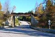 Highway 64 at Field
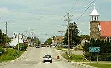 Highway 64 at Noëlville
History
The Sturgeon Falls Road was first assumed by the DHO as Highway 64 on August 25, 1937, shortly after the merger with the DND. The route was 53.6 kilometres (33.3 mi) long when it was first established, connecting Highway 11 and Highway 17.[2] As Highway 69 did not exist between Parry Sound and Sudbury until the 1950s, there was no need for a second highway connection through the French River area.[5] However, on January 25, 1956 the highway was extended south through Nipissing District, followed on February 8, 1956 with an extension through Sudbury District to the now-completed Highway 69.[6] This brought Highway 64 to its current length. Since then, aside from paving and minor realignments, Highway 64 has remained unchanged.[4]
Major intersections
The following table lists the major junctions along Highway 64, as noted by the Ministry of Transportation of Ontario.[1]
| Division | Location | km[1] | mi | Destinations | Notes |
|---|---|---|---|---|---|
| Sudbury | French River | 0.0 | 0.0 | ||
| 5.1 | 3.2 | ||||
| 18.3 | 11.4 | ||||
| Noelville | 21.5 | 13.4 | |||
| French River | 43.5 | 27.0 | Muskrat Creek Bridge; Sudbury – Nipissing boundary | ||
| Nipissing | |||||
| Verner | 72.0 | 44.7 | |||
| Sturgeon Falls | 87.1 | 54.1 | Beginning of Sturgeon Falls Connecting Link agreement | ||
| 89.5 | 55.6 | Sturgeon Falls town limits; end of Connecting Link agreement | |||
| Field | 109.8 | 68.2 | |||
| 110.4 | 68.6 | ||||
| Marten River | 145.0 | 90.1 | |||
| 1.000 mi = 1.609 km; 1.000 km = 0.621 mi | |||||
References
- Ministry of Transportation of Ontario (2010). "Annual Average Daily Traffic (AADT) counts". Archived from the original on July 6, 2011. Retrieved March 21, 2014.
- "Appendix 3 - Schedule of Assumptions and Reversions". Annual Report (Report). Department of Highways. March 31, 1938. p. 80.
- "Highway 69 twinning linking its way north". Daily Commercial News, August 26, 2016.
- Mapart (2010). Ontario Back Road Atlas (Map). Peter Heiler Ltd. p. 105. § K17–18. ISBN 978-1-55198-226-7.
- Ontario Road Map (Map). Cartography by C.P. Robins. Ontario Department of Highways. 1949. § N31–O32.
- "Appendix 3 - Schedule of Assumptions of Sections". Annual Report (Report). Department of Highways. March 31, 1956. pp. 204–205.
External links
| |||||||||||
| |||||||||||
| |||||||||||
| |||||||||||

