Ontario, Oregon
Ontario is the largest city in Malheur County, Oregon, United States. It lies along the Snake River at the Idaho border. The population was 11,366 at the 2010 census.[6] The city is the largest community in the region of far eastern Oregon, also known as the Western Treasure Valley.
Ontario | |
|---|---|
| Ontario, Oregon | |
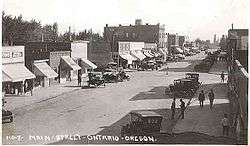 Main Street (now Oregon Street) looking south, early 1920s | |
| Motto(s): Where Oregon Begins | |
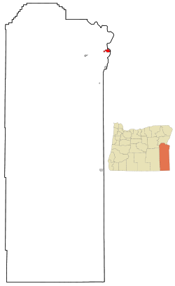 Location in Oregon | |
| Coordinates: 44°1′37″N 116°58′7″W | |
| Country | United States |
| State | Oregon |
| County | Malheur |
| Incorporated | 1899 |
| Government | |
| • Mayor | Riley Hill |
| Area | |
| • Total | 5.17 sq mi (13.38 km2) |
| • Land | 5.17 sq mi (13.38 km2) |
| • Water | 0.00 sq mi (0.00 km2) |
| Elevation | 2,150 ft (655 m) |
| Population | |
| • Total | 11,366 |
| • Estimate (2019)[3] | 10,994 |
| • Density | 2,145.21/sq mi (828.19/km2) |
| Time zone | UTC-7 (Mountain) |
| • Summer (DST) | UTC-6 (Mountain) |
| ZIP code | 97914 |
| Area code(s) | 541 |
| FIPS code | 41-54900[4] |
| GNIS feature ID | 1125001[5] |
| Website | City of Ontario |
Ontario is the principal city of the Ontario, OR-ID Micropolitan Statistical Area, which includes Malheur County in Oregon and Payette County in Idaho.
Ontario is approximately halfway between Portland and Salt Lake City. It is the closest city to the Idaho border along Interstate 84. The city's slogan is "Where Oregon Begins".
History
Ontario was founded on June 11, 1883, by developers William Morfitt, Mary Richardson, Daniel Smith, and James Virtue. In March 1884, Richard Welch started a post office for the quarter of Ontario, so named by James Virtue after Ontario, Canada. Two months later Joseph Morton applied for a Morton post office at an island about one mile south of town, with Oscar Scott as postmaster. Unfortunately for Morton and Scott, merchants Morfitt and Richardson of Malheur City, gold miner Virtue, and lumberman Smith of Baker City acquired more land and were better financed. More importantly, Morfitt had negotiated a train depot for Ontario. All the settlers and speculators knew the railroad was coming and how important that would be to Ontario's future so Scott closed his Morton post office and built a hotel at present-day Ontario. By December, Scott was Ontario's postmaster.
The town continued to grow with the arrival of the Oregon Short Line Railroad in later 1884, and freight and passenger service were added to the town's offerings. Soon after, stock began arriving from Eastern Oregon's cattle ranches to Ontario's stockyard for transshipment to markets throughout the Pacific Northwest. Ontario became one of the largest stockyards in the West. In addition, the construction of the Nevada Ditch and other canals aided the burgeoning agricultural industry, adding those products to Ontario's exports.
Ontario was incorporated by the Oregon Legislative Assembly on February 11, 1899.[7]
A city by the time of World War II, Ontario Mayor Elmo Smith allowed Japanese Americans to settle at a time when much of the West Coast supported their exclusion. Smith told the Associated Press "If the Japs, both alien and nationals, are a menace to the Pacific Coast safety unless they are moved inland, it appears downright cowardly to take any other stand than to put out the call, 'Send them along; we'll cooperate to the fullest possible extent in taking care of them.'" A population of about 134 in the city and surrounding county before the war ballooned to 1,000 as the county recruited farm workers during the war.[8]
Geography
Ontario is located at an elevation of 2,150 feet (660 m) above sea level.
According to the United States Census Bureau, the city has a total area of 5.17 square miles (13.39 km2), all of it land.[9]
Climate
Ontario has a cold desert dry-summer continental climate, abbreviated "BSk" on climate maps.[10]
| Climate data for Ontario, OR | |||||||||||||
|---|---|---|---|---|---|---|---|---|---|---|---|---|---|
| Month | Jan | Feb | Mar | Apr | May | Jun | Jul | Aug | Sep | Oct | Nov | Dec | Year |
| Record high °F (°C) | 64 (18) |
67 (19) |
85 (29) |
94 (34) |
103 (39) |
109 (43) |
113 (45) |
113 (45) |
104 (40) |
93 (34) |
74 (23) |
66 (19) |
113 (45) |
| Mean maximum °F (°C) | 48.1 (8.9) |
57.0 (13.9) |
70.8 (21.6) |
80.9 (27.2) |
91.7 (33.2) |
98.6 (37.0) |
103.9 (39.9) |
101.9 (38.8) |
93.9 (34.4) |
81.5 (27.5) |
62.5 (16.9) |
51.3 (10.7) |
104.5 (40.3) |
| Average high °F (°C) | 35.4 (1.9) |
43.6 (6.4) |
56.2 (13.4) |
64.6 (18.1) |
74.2 (23.4) |
83.0 (28.3) |
93.8 (34.3) |
91.3 (32.9) |
81.0 (27.2) |
65.4 (18.6) |
47.8 (8.8) |
36.0 (2.2) |
62.5 (16.9) |
| Daily mean °F (°C) | 28.6 (−1.9) |
34.0 (1.1) |
44.0 (6.7) |
50.6 (10.3) |
59.8 (15.4) |
67.6 (19.8) |
76.5 (24.7) |
73.6 (23.1) |
63.5 (17.5) |
50.5 (10.3) |
38.0 (3.3) |
28.7 (−1.8) |
50.2 (10.1) |
| Average low °F (°C) | 20.9 (−6.2) |
24.5 (−4.2) |
31.7 (−0.2) |
36.9 (2.7) |
45.2 (7.3) |
52.4 (11.3) |
58.9 (14.9) |
55.9 (13.3) |
45.6 (7.6) |
35.4 (1.9) |
28.0 (−2.2) |
20.6 (−6.3) |
38.0 (3.3) |
| Mean minimum °F (°C) | 4.6 (−15.2) |
9.8 (−12.3) |
20.1 (−6.6) |
24.5 (−4.2) |
31.4 (−0.3) |
40.1 (4.5) |
47.3 (8.5) |
44.3 (6.8) |
33.2 (0.7) |
22.4 (−5.3) |
14.2 (−9.9) |
5.2 (−14.9) |
−1.7 (−18.7) |
| Record low °F (°C) | −25 (−32) |
−24 (−31) |
9 (−13) |
17 (−8) |
25 (−4) |
31 (−1) |
34 (1) |
33 (1) |
24 (−4) |
9 (−13) |
−6 (−21) |
−23 (−31) |
−25 (−32) |
| Average precipitation inches (mm) | 1.09 (28) |
0.86 (22) |
0.98 (25) |
0.70 (18) |
1.12 (28) |
0.68 (17) |
0.33 (8.4) |
0.27 (6.9) |
0.36 (9.1) |
0.70 (18) |
1.06 (27) |
1.55 (39) |
8.35 (212) |
| Average snowfall inches (cm) | 3.41 (8.7) |
2.46 (6.2) |
0.38 (0.97) |
0.00 (0.00) |
0.00 (0.00) |
0.00 (0.00) |
0.00 (0.00) |
0.00 (0.00) |
0.00 (0.00) |
0.00 (0.00) |
2.83 (7.2) |
7.27 (18.5) |
13.08 (33.2) |
| Average precipitation days (≥ 0.01 in.) | 8.5 | 7.3 | 8.3 | 6.6 | 7.2 | 5.3 | 2.0 | 2.1 | 3.1 | 4.9 | 9.2 | 9.8 | 72.6 |
| Average snowy days (≥ 0.1 in.) | 2.4 | 1.8 | 0.4 | 0.0 | 0.0 | 0.0 | 0.0 | 0.0 | 0.0 | 0.0 | 1.4 | 3.3 | 9.0 |
| Source: [11] | |||||||||||||
Demographics
| Historical population | |||
|---|---|---|---|
| Census | Pop. | %± | |
| 1890 | 200 | — | |
| 1900 | 445 | 122.5% | |
| 1910 | 1,248 | 180.4% | |
| 1920 | 2,039 | 63.4% | |
| 1930 | 1,941 | −4.8% | |
| 1940 | 3,551 | 82.9% | |
| 1950 | 4,465 | 25.7% | |
| 1960 | 5,101 | 14.2% | |
| 1970 | 6,523 | 27.9% | |
| 1980 | 8,814 | 35.1% | |
| 1990 | 9,392 | 6.6% | |
| 2000 | 10,985 | 17.0% | |
| 2010 | 11,366 | 3.5% | |
| Est. 2019 | 10,994 | [3] | −3.3% |
| Sources:[6][12] | |||
2010 census
As of the census[2] of 2010, there were 11,366 people, 4,275 households, and 2,678 families living in the city. The population density was 2,198.5 inhabitants per square mile (848.8/km2). There were 4,620 housing units at an average density of 893.6 per square mile (345.0/km2). The racial makeup of the city was 69.5% White, 0.7% African American, 1.3% Native American, 2.2% Asian, 0.1% Pacific Islander, 22.6% from other races, and 3.5% from two or more races. Hispanic or Latino of any race were 41.3% of the population.
There were 4,275 households of which 35.4% had children under the age of 18 living with them, 41.3% were married couples living together, 16.0% had a female householder with no husband present, 5.3% had a male householder with no wife present, and 37.4% were non-families. 30.9% of all households were made up of individuals and 15.3% had someone living alone who was 65 years of age or older. The average household size was 2.60 and the average family size was 3.28.
The median age in the city was 32.1 years. 28.9% of residents were under the age of 18; 12.3% were between the ages of 18 and 24; 23% were from 25 to 44; 21% were from 45 to 64; and 14.9% were 65 years of age or older. The gender makeup of the city was 47.3% male and 52.7% female.
2000 census
As of the census[4] of 2000, there were 10,985 people, 4,084 households, and 2,634 families living in the city. The population density was 2,459.3 people per square mile (948.8/km²). There were 4,436 housing units at an average density of 993.1 per square mile (383.2/km²). The racial makeup of the city was 69.27% White, 0.55% African American, 2.69% Asian, 0.88% Native American, 0.15% Pacific Islander, 23.09% from other races, and 3.39% from two or more races. Hispanic or Latino of any race were 32.05% of the population.
There were 4,084 households out of which 35.6% had children under the age of 18 living with them, 47.4% were married couples living together, 13.1% had a female householder with no husband present, and 35.5% were non-families. 30.4% of all households were made up of individuals and 15.4% had someone living alone who was 65 years of age or older. The average household size was 2.63 and the average family size was 3.30.
In the city, the population was spread out with 30.5% under the age of 18, 11.5% from 18 to 24, 24.0% from 25 to 44, 18.6% from 45 to 64, and 15.4% who were 65 years of age or older. The median age was 31 years. For every 100 females, there were 89.7 males. For every 100 females age 18 and over, there were 85.2 males.
The median income for a household in the city was $29,173, and the median income for a family was $35,625. Males had a median income of $29,775 versus $21,967 for females. The per capita income for the city was $14,683. About 16.4% of families and 20.8% of the population were below the poverty line, including 29.0% of those under age 18 and 14.3% of those age 65 or over.
Economy

The Heinz Frozen Food Company (formerly Ore-Ida), a subsidiary of H. J. Heinz Company, processes locally grown potatoes, and annually produces over 600,000,000 pounds (270,000,000 kg) of 75 different potato products, while employing approximately 1,000.[14] Tater tots were first created and manufactured here in 1953 (commercial distribution began in 1956).[15]
St. Alphonsus Medical Center is a 49-bed, acute-care hospital, serving Ontario and the surrounding communities in Eastern Oregon and southwestern Idaho; it is part of the hospital system of Saint Alphonsus Regional Medical Center in Boise, Idaho.[16]
In November 2018, voters overturned a ban on recreational marijuana dispensaries in the town, several years after Oregon legalized recreational marijuana usage. As Ontario borders Idaho (where marijuana remains illegal for all purposes), local news outlets reported that by November 2019 the city's dispensaries were generating a significant amount of revenue from Idaho residents driving across the state line.[17]
Education
Ontario is served by the Ontario School District (8C) public schools[18] and by private schools.
Public schools
- Ontario High School 9-12
- Ontario Middle School 7-8
- Aiken Elementary K-5
- Alameda Elementary K-6
- Cairo Elementary K-5
- May Roberts Elementary K-6
- Pioneer Elementary K-5
Private schools
- Treasure Valley Christian School Pre K-12
- St. Peter's Catholic School K-8
- Four Rivers Community School (charter school) K-12
Media
Ontario's daily paper is the Argus Observer.
Transportation
- Bus
- Snake River Transit provides public transportation between points in Ontario and nearby Fruitland and Payette.[19]
- Ontario is a stop on the Eastern POINT intercity bus line between Bend and Ontario. It makes one stop per day in each direction.[20]
- Greyhound Lines offers service east and west on I-84 from Ontario.[21]
- Air
- Highway

Notable people
- Madeline DeFrees, poet
- Tom Edens, MLB pitcher
- AJ Feeley, NFL quarterback
- Erik Fisher, skier
- Sally Flynn, also known as Sally Hart, singer on The Lawrence Welk Show
- Charles C. Gossett, Idaho politician
- Joel Hardin, Border Patrol agent and mantracker
- Denny Jones, congressman and rancher
- Randall B. Kester, Oregon judge
- Phyllis McGinley, children's author
- Elmo Smith, newspaper editor, mayor of Ontario and governor of Oregon
- Leland Evan Thomas, WWII pilot killed in action at Guadalcanal
- David Wilcox, NFL linebacker
- Laura LeBoutillier, Gardener
Sister cities
Ontario has one sister city, as designated by Sister Cities International:[22]
See also
- Oregon Short Line Railroad Depot
References
- "2018 U.S. Gazetteer Files". United States Census Bureau. Retrieved Feb 12, 2020.
- "U.S. Census website". United States Census Bureau. Retrieved 2012-12-21.
- "Population and Housing Unit Estimates". Retrieved May 21, 2020.
- "U.S. Census website". United States Census Bureau. Retrieved 2008-01-31.
- "US Board on Geographic Names". United States Geological Survey. 2007-10-25. Retrieved 2008-01-31.
- "US Gazetteer files: 2010, 2000, and 1990". United States Census Bureau. 2011-02-12. Retrieved 2011-04-23.
- Leeds, W. H. (1899). "Special Laws". The State of Oregon General and Special Laws and Joint Resolutions and Memorials Enacted and Adopted by the Twentieth Regular Session of the Legislative Assembly. Salem, Oregon: State Printer: 683.
- Robert Kinoshita/Benjamin Tanaka/Augustus "Gus" Tanaka in "Resettlement and Return to the West Coast," Hirahara, Naomi and Jensen, Gwenn, eds., Silent Scars of Healing Hands (California State University, Fullerton: Center for Oral and Public History, 2004), p. 143
- "US Gazetteer files 2010". United States Census Bureau. Archived from the original on 2012-01-25. Retrieved 2012-12-21.
- "Ontario, Oregon Köppen Climate Classification (Weatherbase)". weatherbase.com. Retrieved 24 August 2016.
- "NOWData - NOAA Online Weather Data". NOAA. Retrieved June 17, 2020.
- Moffatt, Riley. Population History of Western U.S. Cities & Towns, 1850-1990. Lanham: Scarecrow, 1996, 214.
- United States Census Bureau. "Census of Population and Housing". Retrieved October 2, 2014.
- Worksource Oregon Department of Community Colleges and Workforce Development - Workforce Partners
- Lukas, Paul (November 1, 2003). "Mr. Potato Head – A Dirt-Poor Farmer Turned Spud Scraps into Gold". CNN Money. Retrieved May 1, 2012.
- About Us
- https://www.ktvb.com/mobile/article/news/local/this-is-the-marijuana-capital-of-idaho-pot-sales-bring-boomtown-status-to-ontario/277-3d84d233-63fe-452d-8038-22de046c8b34
- "Ontario School District: Our District". ontario.k12.or.us. Retrieved 24 August 2016.
- "snakerivertransit.com". snakerivertransit.com. Retrieved 24 August 2016.
- "Eastern Point Schedule". Oregon Department of Transportation. Archived from the original on November 4, 2016. Retrieved January 5, 2016.
- "Greyhound". Archived from the original on 2006-03-12. Retrieved 2020-04-25.
- "Ontario, Oregon". Interactive City Directory. Sister Cities International. Retrieved 8 May 2013.
External links
| Wikivoyage has a travel guide for Ontario (Oregon). |
| Wikimedia Commons has media related to Ontario, Oregon. |
- Ontario Chamber of Commerce
- Ontario information from the Oregon Blue Book
- Panoramic photos of Ontario from the Library of Congress
- 1930s-1940s farming photos of Ontario from the Library of Congress
Municipalities and communities of Malheur County, Oregon, United States | ||
|---|---|---|
| Cities | 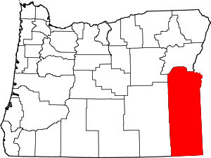 Malheur County map | |
| CDPs | ||
| Other unincorporated communities | ||
| Ghost town | ||
| Indian reservation | ||
| Footnotes | ‡This populated place also has portions in an adjacent county or counties | |
| Authority control |
|
|---|