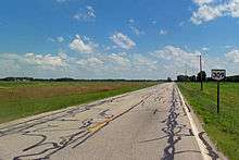
Ohio State Route 309
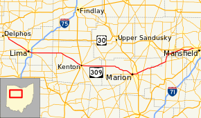
State Route 309 (SR 309) is an east–west highway in central Ohio. Its western terminus is at its interchange with U.S. Route 30 (US 30) near Delphos, and its eastern terminus is at its interchange with US 30 in Mansfield. Its current route takes it through the cities of Lima, Kenton, Marion, Galion, and Ontario; as well as the villages of Elida and Caledonia.
| |||||||
|---|---|---|---|---|---|---|---|
 | |||||||
| Route information | |||||||
| Maintained by ODOT | |||||||
| Length | 103.579 mi[1][2] (166.694 km) | ||||||
| Existed | 1973–present | ||||||
| Major junctions | |||||||
| West end | |||||||
| East end | |||||||
| Location | |||||||
| Counties | Allen, Hardin, Marion, Morrow, Crawford, Richland | ||||||
| Highway system | |||||||
| |||||||

Route description
Within the city of Lima, SR 309 is officially designated along SR 81 (North Street) from Jameson Avenue to Union Street, south along Union Street (concurrent with SR 65, and east along Elm Street (SR 117).[1][2] The eastbound direction of SR 309 is signed south along Jameson Street to SR 117, then east along it while the westbound direction is signed along Central Avenue and Front Street.[3][4]
History
SR 309's current route was the route of U.S. Route 30S, a divided U.S. route of US 30 until November 1973 when what was US 30N became the mainline of US 30.[5][6] US 30S was so numbered in the 1920s to avoid conflict from local business owners worried about the diversion of traffic from their shops along the southern route.[7]
The only significant change of the route since this certification is its western terminus, which originally was with U.S. 30 in Delphos. When U.S. 30's bypass around Delphos was completed in 1981, Ohio 309's western terminus was made the easternmost interchange of the bypass.
Before being used as its current route, the route number 309 was used as the route number of what is now State Route 541. It was replaced with the now defunct State Route 271 in 1935.[8][9][10]
Harding Highway
.svg.png)
The Lincoln Highway left the present State Route 309, a better-quality road at the time, in favor of the direct Delphos-Mansfield route now generally followed by US 30. Only two weeks after the official route was announced in September 1913, it had already been redefined to a straighter path between Lima and Galion; the rest of the straightening came later. The towns along the route got together and formed the Harding Highway, named after President Warren G. Harding, who had grown up in the area.
This Harding Highway continued east via the Lincoln Highway to Canton, turning southeast from there to Steubenville via State Route 43. To the west, it was marked along the Lincoln Highway to Van Wert, heading west along the present U.S. Route 224, roughly State Road 114, State Road 10, State Road 8, and State Road 2 through Indiana to the Illinois state line.[11]
Major intersections
| County | Location[2] | mi[1] | km | Destinations | Notes | |||
|---|---|---|---|---|---|---|---|---|
| Allen | Marion Township | 0.000– 0.546 | 0.000– 0.879 | Interchange; eastbound US 30 exit / westbound US 30 entrance only; western terminus of SR 309 | ||||
| Lima | 11.798 | 18.987 | Western terminus of SR 81 concurrency (westbound only); western end of SR 309 one-way pair | |||||
| 12.167 | 19.581 | Western end of SR 117 concurrency (eastbound only) | ||||||
| 13.044 | 20.992 | Western end of southbound SR 65 concurrency (eastbound only) | ||||||
| 13.339 | 21.467 | Western end of SR 65 northbound concurrency; eastern end of SR 309 one-way pair | ||||||
| 13.557 | 21.818 | Eastern end of SR 65 concurrency | ||||||
| 14.916– 15.023 | 24.005– 24.177 | Exit 125 (I-75) | ||||||
| Bath–Perry township line | 15.209 | 24.477 | Eastern end of SR 117 concurrency | |||||
| Hardin | Liberty–Marion township line | 27.205 | 43.782 | Eastern end of SR 235 concurrency | ||||
| 28.209 | 45.398 | Western end of SR 235 concurrency | ||||||
| Marion Township | 29.560 | 47.572 | Western terminus SR 701 | |||||
| 30.334 | 48.818 | Northern terminus of SR 195 | ||||||
| Kenton | 41.165 | 66.249 | ||||||
| 41.232 | 66.356 | |||||||
| Marion | Grand–Montgomery township line | 53.191 | 85.603 | |||||
| Big Island Township | 62.521 | 100.618 | Northern terminus of SR 203 | |||||
| Marion | 66.941 | 107.731 | Western end of SR 95 concurrency | |||||
| 68.088 | 109.577 | SR 4 / SR 423 / SR 739 on a one-way pair; northern terminus of SR 739 (at Center Street) | ||||||
| 68.248 | 109.835 | SR 4 / SR 423 / SR 739 on a one-way pair; northern terminus of SR 739 (at Center Street) | ||||||
| 68.395 | 110.071 | Eastern end of SR 95 concurrency | ||||||
| Marion Township | 70.672– 70.788 | 113.736– 113.922 | Interchange | |||||
| Claridon Township | 73.915 | 118.955 | ||||||
| 77.453 | 124.649 | Northern terminus of SR 746 | ||||||
| Morrow |
No major junctions | |||||||
| Marion | Tully Township | 83.674 | 134.660 | Southern terminus of SR 100 | ||||
| Morrow | Washington Township | 85.911 | 138.260 | Western terminus of SR 288 | ||||
| 86.163 | 138.666 | Southern end of SR 61 concurrency | ||||||
| Crawford | Galion | 89.860 | 144.616 | Western end of SR 19 concurrency; southern terminus of SR 598 | ||||
| 91.130 | 146.660 | Eastern end of SR 19 concurrency; western terminus of SR 97 | ||||||
| 93.229 | 150.038 | Northern end of SR 61 concurrency | ||||||
| Richland | Springfield Township | 97.180 | 156.396 | Eastern terminus of SR 181 | ||||
| Ontario | 98.186 | 158.015 | ||||||
| 100.571– 100.821 | 161.853– 162.256 | Western terminus of SR 430 | ||||||
| 102.104– 102.660 | 164.320– 165.215 | West Fourth Street | Interchange | |||||
| Mansfield | 103.579 | 166.694 | Eastern terminus of SR 309; eastbound US 30 entrance / westbound US 30 exit only | |||||
1.000 mi = 1.609 km; 1.000 km = 0.621 mi
| ||||||||
References
- "Data Download - ODOT TIMS (Road Inventory shapefile)". Ohio Department of Transportation. Retrieved April 14, 2019.
- "DESTAPE". Ohio Department of Transportation. August 30, 2017. Retrieved April 14, 2019.
- Google (April 14, 2019). "Ohio State Route 309" (Map). Google Maps. Google. Retrieved April 14, 2019.
- Google (April 14, 2019). "Westbound SR 309 in Lima" (Map). Google Maps. Google. Retrieved April 14, 2019.
- "Renaming Of Rt. 30s Draws No Opposition". The Lima News. October 12, 1973. p. 13. Retrieved August 20, 2014.
- Butko, Brian (2013) [2005]. Greetings from the Lincoln Highway. Stackpole Books. p. 84. Retrieved August 20, 2014.
- Associated Press (September 20, 1973). "Eye U.S. 30 Location". The Times Bulletin. p. 1. Retrieved August 20, 2014.
- Map of Ohio Showing State Highway System (MrSID) (Map). Cartography by O.W. Merrell, Director. Ohio Department of Highways. 1932. Retrieved August 19, 2013.
- Map of Ohio Showing State Highway System (MrSID) (Map). Cartography by O.W. Merrell, Director. ODOH. 1934. Retrieved August 19, 2013.
- Official 1935 Ohio Highway Map (MrSID) (Map). Cartography by John Jaster, Jr., Director. ODOH. 1935. Retrieved August 19, 2013.
- Rand McNally Auto Road Atlas, 1926, accessed via the Broer Map Library