Ohio State Route 430
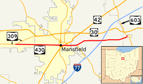
State Route 430 (SR 430, OH 430) is an east–west state highway in the northern portion of Ohio. The western terminus of State Route 430 is at an interchange with State Route 309 in Ontario. Its eastern terminus is at a T-intersection with State Route 603 just outside Mifflin.
| ||||
|---|---|---|---|---|
 | ||||
| Route information | ||||
| Maintained by ODOT | ||||
| Length | 13.08 mi[1] (21.05 km) | |||
| Existed | 1960–present | |||
| Major junctions | ||||
| West end | ||||
| East end | ||||
| Location | ||||
| Counties | Richland, Ashland | |||
| Highway system | ||||
| ||||

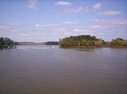
A view of Charles Mill Lake from the SR 430 bridge in Ashland County, looking north.
Route description
This state highway runs through portions of Richland and Ashland Counties. No part of State Route 430 is included as a part of the National Highway System.[2]
History
State Route 430 was designated circa 1960 along the routing that it currently occupies. No changes of major significance have taken place to the highway since its inception.[3][4]
Major intersections
| County | Location | mi[1] | km | Destinations | Notes |
|---|---|---|---|---|---|
| Richland | Ontario | 0.00 | 0.00 | Partial interchange, no access from SR 309 westbound to SR 430 eastbound | |
| Mansfield | 4.92 | 7.92 | |||
| 5.06 | 8.14 | Western end of southbound US 42 concurrency | |||
| 5.13 | 8.26 | ||||
| 5.36 | 8.63 | Western end of northbound US 42 concurrency | |||
| 5.63 | 9.06 | Eastern end of US 42 concurrency | |||
| 5.96 | 9.59 | Western end of SR 39 concurrency | |||
| Madison Township | 6.96 | 11.20 | Eastern end of SR 39 concurrency | ||
| Ashland | Mifflin Township | 13.08 | 21.05 | ||
1.000 mi = 1.609 km; 1.000 km = 0.621 mi
| |||||
References
- Ohio Department of Transportation. "Technical Services Straight Line Diagrams". Retrieved 2008-03-16.
- National Highway System: Ohio (PDF) (Map). Federal Highway Administration. December 2003. Retrieved 2010-09-15.
- Ohio State Map (Map). Ohio Department of Transportation. 1959.
- Ohio State Map (Map). Ohio Department of Transportation. 1961.
External links
This article is issued from Wikipedia. The text is licensed under Creative Commons - Attribution - Sharealike. Additional terms may apply for the media files.