Oatley, New South Wales
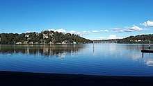
Oatley is a suburb in Southern Sydney in the state of New South Wales, Australia. It is located 18 kilometres (11 miles) south of the Sydney central business district and is part of the St George area. Oatley lies in the local government area of Georges River Council. It lies on the northern side of the tidal estuary of the Georges River and its foreshore includes part of Oatley Bay and Lime Kiln Bay, and all of Neverfail Bay, Gungah Bay and Jewfish Bay.
| Oatley Sydney, New South Wales | |||||||||||||||
|---|---|---|---|---|---|---|---|---|---|---|---|---|---|---|---|
 Oatley Clock Tower, Frederick Street | |||||||||||||||
| Population | 10,486 (2016 census)[1] | ||||||||||||||
| Established | 1883 | ||||||||||||||
| Postcode(s) | 2223 | ||||||||||||||
| Location | 18 km (11 mi) south of Sydney CBD | ||||||||||||||
| LGA(s) | Georges River Council | ||||||||||||||
| State electorate(s) | Oatley | ||||||||||||||
| Federal Division(s) | Banks | ||||||||||||||
| |||||||||||||||

History
Evidence of Aboriginal occupation of the land now known as Oatley exists in the form of numerous shell middens and rock shelters near the shore of Georges River.[2]
This suburb's name can be traced to James Oatley Snr, watch-maker, who was transported to Botany Bay for life in 1814. Seven years later, in 1821, Governor Lachlan Macquarie granted Oatley a conditional pardon and appointed him overseer of the Town Clock for his work in installing the clock at Hyde Park Barracks.[3][4]
On 17 August 1898, Oatley was the site of a pursuit and gun battle involving a party of police and George Peisley (or Peasley), a fugitive cattle and horse thief, who was using a sandstone cave on the eastern side of Gungah Bay as his hide out.[5] Peisley escaped capture,[6] but was arrested at Arncliffe on the following day[7] and eventually sentenced to four years hard labour.[8]
The post office opened in 1903, thus giving the district its official name of Oatley. Prior to this, the area west of the railway line was officially in the suburb of Hurstville and attached to the Hurstville Post Office with "Oatley's" in parenthesis at the end of the address. Likewise, the streets east of the railway line were officially in the suburb of Kogarah and attached to the Kogarah Post Office. In the late 1890s both Hurstville and Kogarah were much larger suburbs and were later divided up into separate suburbs.
Oatley is notable as the terminus of the first railway electrification project in Sydney, which reached this station from Sydney Central in 1926.
When a group gathered in Oatley Park in December 1959, to form a Bowling Club, it was inevitable that the founding members should choose a clock as the club emblem. The hands on the clock were set at 15 minutes after 10 - the precise time the first meeting of the Oatley Bowls Club was opened.[9] The Club has since closed, though the greens and Club premises remain.[10]
The Oatley campus of Alexander Mackie College of Advanced Education opened in 1981 on the site of the former Judd's Brick Works and quarry. In 1981, when many teachers' colleges were amalgamated, it became The St George Institute of Education, part of Sydney College of Advanced Education, and subsequently a campus of the University of New South Wales. It is now a secondary school – the Oatley Senior Campus of the Georges River College.[11]
Local Industries
Although now an entirely residential suburb, Oatley was the site of several industries in the past.
For over a century, Sydney Rock Oysters were grown commercially along the shores of Georges River at Oatley. Freshwater from the Woronora River, a tributary that joins the Georges River opposite Oatley, lowered salinity resulting in good-tasting oysters.
Six families of oyster farmers worked from the head of Neverfail Bay just to the east of the Como Railway Bridge[12] There was a smaller oyster farming site at the head of Jewfish Bay just outside the eastern boundary of Oatley Park. Oysters were cultivated both on racks on the river mudbanks and, west of the Como rail bridge, on the rocks of shoreline leases. For many years, oysters were shipped to market in hessian sacks from Oatley railway station by electric rail parcel vans. There was also long-standing criminal activity involving the theft of oysters from the leases.[13][14]Oyster farmers would at times patrol their leases at night, using boats fitted with small searchlights that could scan their shoreline leases.
This local oyster farming industry survived increasing urbanisation and water pollution but finally succumbed in the mid-1990s to the spread of 'QX disease',[12][15] which is caused by a parasite that affects Sydney Rock Oysters.[16]
Judd's Hurstville Brickworks was located on the northern side of Hurstville Road; its 13-hectare site straddled the northern boundary of Oatley with neighbouring Mortdale. It operated from 1884 to 1972, making bricks using shale from a quarry that occupied much of the Oatley-end of the site. Two tall brick chimneys were demolished in June 1973, along with the brick-making plant and kilns.[17] Fifteen brick cottages were built along the western side of Judd Street, Oatley, to rent to workers at the brickworks; some still survive.
A factory owned by Albert Page, which once existed on the south-eastern corner of Rosa Street and Hurstville Road, manufactured vehicle number plates from 1935 to the 1950s.[18][19][20] Surelli Furniture operated a factory on the western side of Ada Street near the junction with Hurstville Road for many years.[21] The Cuthbertson family ran a small factory making children's and babies' shoes behind their residence at 46 Rosa Street, from after WWI until 1959, when they moved the factory to a site in Mortdale.[22][23][24]
Heritage listings
Oatley has a number of heritage-listed sites, including:
- Illawarra railway: Oatley railway station[25]
- over Georges River: Old Como railway bridge[26]
- Residential building - 92 Rosa Street, Oatley.[27]
Commercial area
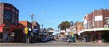
The main shopping centre is located on Oatley Avenue and Frederick Street, near the railway station. A small group of shops and a Coles Supermarket are located on Mulga Road and referred to as the Oatley West shops. A third group of shops at the intersection of Baker Street and Landsdown Parade - in the locality of Jewfish Point - is now mainly converted to non-retail businesses. The village atmosphere, along with good cafes, and large parklands located in the centre of the shopping area adjacent to the train station, has led Oatley to be commonly mentioned as the most picturesque shopping village in the St George area.
Transport
Originally, the railway ran east of the present Mortdale Railway Sheds and down the western side of Oatley Avenue, on land that is now the Oatley Memorial Gardens. The first station platform was located at the western end of Frederick Street and extended north to the Oatley Hotel car park. The railway was realigned and the current station opened in 1905.[26] The electrification of the passenger network began in 1926[28] with the first suburban electric service running between Sydney's Central Station and the suburb of Oatley approximately 20 km south of Sydney.
Oatley railway station is the last station on the Sydney Trains Eastern Suburbs & Illawarra railway line before crossing the Georges River to Como in the Sutherland Shire. The 955 bus route operates a service from Mortdale through Oatley West and Oatley to Hurstville.
Parks
The area's main attraction is Oatley Park but there are also a number of local bush parks surrounding the suburb: Oatley Point Reserve, Oatley Pleasure Grounds, Moore Reserve, Renown Park, Lime Kiln Bay Bushland Sanctuary, Giriwa Picnic Ground, Stevens Reserve, Meyer Reserve, and the Miles Dunphy Bushland Reserve (in which foot tracks were improved in 2011, by Hurstville Council). They attract many birds both native and introduced, with Oatley Park alone recording 146 species; as many as 90 recently.[29][30]
Oatley Park
Oatley Park[31] is a tree covered promontory that is almost completely surrounded by the Georges River. It covers an area of about 45 hectares (110 acres) and it is one of the significant areas of bushland remaining in the St George area.[32]
Oatley Park became a public recreation area on 25 March 1887. In October 1893, when the nearby residential subdivision was sold off, it was known as Peakhurst Park. It was renamed to Oatley Park in March 1922.
It protects important examples of the natural environment which occur throughout the park. In addition, there is a swimming area, a playground featuring an old steamroller, lookouts, barbecues, a soccer/cricket oval, and a "castle".[33] The man-made wetlands of Lime Kiln Bay Reserve which adjoin Oatley Park provide refuge for bird species such as chestnut teal, Pacific black ducks, dusky moorhens and purple swamphens.[34] Native mammals which are uncommon in the region can still be found within the park, including the short-beaked echidna and the swamp wallaby.[35][36]
Oatley Pleasure Grounds
Oatley Pleasure Grounds is a bush park located on Annette Street. It covers an area of 3.4 hectares (8.4 acres) and was built by Harry Linmark before 1934. Numerous performances occurred in the park previously, and a wine bar was constructed. The bar was later shut down due to noise complaints.[37]
Schools
Churches
Landmarks
- Oatley RSL & Community Club [48]
- Oatley Bay, Gungah Bay, Lime Kiln Bay, Neverfail Bay, Jewfish Bay
- Oatley Point, Lime Kiln Point, Lime Kiln Head, Jewfish Bay Point
- Hills Lookout, Websters Lookout
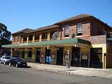
- The Oatley Hotel (Oatley Pub)[49]
- Oatley Library
- Myles Dunphy Reserve, a site of ecological significance.[50] However, Hurstville City Council has plans to sell off a large part of this land to private business.[51]
- The 1905 George Fincham Pipe Organ located at Hurstville Christadelphian District Ecclesia is a historically-significant[52] musical instrument in the area.
Community events
- Oatley Lions Village Festival — An annual festival held on the third Saturday in October in Oatley Memorial Gardens and part of Frederick Street[53]
- Oatley West Arts and Crafts Festival[54] - An event held at Oatley West Public school each year
- Oatley Spring Fair — A fair held biennially at Oatley Public School
Sport
Water sports and recreation are a way of life in the peninsula suburb of Oatley whose eastern, southern and western boundaries are formed by the Georges River and its bays. Oatley has many sporting teams and sporting fields:
- Renown United, the local Rugby league team, play at Renown Park.
- Oatley Rugby Club,[55] play Rugby Union at H.V Evatt Park in Lugarno.
- Oatley RSL,[56] who play at Renown Park, and All Saints Oatley West,[57] who play at Oatley Park, are the two association football teams.
- Oatley Netball Club.
- Oatley RSL Youth Club Gymnastics and Sport Aerobics[58]
Population
Demographics
According to the 2016 census, there were 10,486 people in Oatley. 71.8% of people were born in Australia. The next most common countries of birth were China 6.0%, England 2.9%, Hong Kong 1.3% and New Zealand 1.0%. 72.1% of people only spoke English at home. Other languages spoken at home included Mandarin 6.9%, Cantonese 3.4%, Greek 3.1%, Croatian 1.6% and Macedonian 1.3%. The most common responses for religious affiliation were Catholic 27.0%, No Religion 25.4%, Anglican 16.6% and Eastern Orthodox 6.6%.[1]
Notable residents
- Myles Joseph Dunphy (1891-1985) - architect and conservationist [59]
- Milo Kanangra Dunphy (1928-1996), the son of Myles Dunphy, and also an architect and conservationist.
- Fiona Margaret Hall - an artistic photographer and sculptor.
- John O'Grady (writer) - humorist and author of They're a Weird Mob.
References
- Australian Bureau of Statistics (27 June 2017). "Oatley (State Suburb)". 2016 Census QuickStats. Retrieved 1 February 2018.

- Kayandel Archeological Services (January 2010). "The Georges River Estuary Cultural Heritage Desktop Assessment - Draft B" (PDF).
- Arch Gray Collection, Society of Australian Genealogists, Sydney, NSW
- AGCI Index (Australian Genealogical Computer Index), Society of Australian Genealogists
- Hatton, D. J. (1981). Oatley in early days. Hurstville Historical Society. [Hurstville, N.S.W.]: Hurstville Historical Society. p. 24. ISBN 0959850295. OCLC 27615717.
- "PEISLEY PURSUED". Evening News (Sydney, NSW : 1869 - 1931). 18 August 1898. p. 3. Retrieved 18 June 2019.
- "CAPTURE OF PEISLEY". Evening News (Sydney, NSW : 1869 - 1931). 19 August 1898. p. 6. Retrieved 18 June 2019.
- "CASE OF GEORGE PEISLEY". Daily Telegraph (Sydney, NSW : 1883 - 1930). 10 October 1898. p. 2. Retrieved 18 June 2019.
- The Book of Sydney Suburbs, Compiled by Frances Pollen, Angus & Robertson Publishers, 1990, Published in Australia ISBN 0-207-14495-8, page 193
- http://orao.oatleypark.com/myles2.html
- Oatley Senior Campus, www.oatleysnr-h.schools.nsw.edu.au
- Robertson, Roger (2014). "Neverfail Bay, Oatley". dictionaryofsydney.org. Retrieved 29 March 2019.
- "Theft of Oysters". Propeller (Hurstville, NSW : 1911 - 1954). 21 March 1919. p. 1. Retrieved 19 February 2020.
- "OYSTER-FARMERS' PROBLEMS". Propeller (Hurstville, NSW : 1911 - 1954). 3 July 1941. p. 6. Retrieved 19 February 2020.
- "IN BRIEF". Canberra Times (ACT : 1926 - 1995). 18 April 1995. p. 4. Retrieved 30 March 2019.
- "QX oyster disease". www.dpi.nsw.gov.au. 26 April 2016. Retrieved 29 March 2019.
- Ltd, Civica Pty. "Judds Brickworks, Mortdale NSW, Believed to be 1972". georgesriver.spydus.com. Retrieved 30 March 2019.
- "NEW CAR NUMBER PLATES". Propeller (Hurstville, NSW : 1911 - 1954). 6 May 1937. p. 8. Retrieved 30 March 2019.
- "Mr A. Page is getting ready to produce new three-letter three-figure number plates for N.S.W." Sunday Herald (Sydney, NSW : 1949 - 1953). 19 November 1950. p. 2. Retrieved 30 March 2019.
- "He Will Make Our New Number Plates". Age (Melbourne, Vic. : 1854 - 1954). 24 November 1950. p. 3. Retrieved 30 March 2019.
- Ltd, CreditorWatch Pty. "SURELLI FURNITURE PTY LTD (ACN# 001 665 783)". CreditorWatch Express. Retrieved 30 March 2019.
- "DEATH OF MR. CUTHBERTSON". Propeller (Hurstville, NSW : 1911 - 1954). 8 January 1948. p. 2. Retrieved 31 March 2019.
- "Advertising - WANTED EXPERIENCED BOOT TRADE MACHINIST FOR NURSERY SHOES". Propeller (Hurstville, NSW : 1911 - 1954). 7 October 1954. p. 5. Retrieved 31 March 2019.
- Cuthbertson, Alan (August 1997). "Oatley Personalities Past and Present: Albert Ernest "Bert" Cuthbertson - his family - the shoe factory" (PDF). pp. 30–35.
- "Oatley Railway Station group". New South Wales State Heritage Register. Office of Environment and Heritage. H01214. Retrieved 18 May 2018.
- "Como Rail Bridge". New South Wales State Heritage Register. Office of Environment and Heritage. H01624. Retrieved 18 May 2018.
- "House | NSW Environment & Heritage". www.environment.nsw.gov.au. Retrieved 1 April 2019.
- Jubilee of Sydney's Electric Trains Brady, I.A. Australian Railway Historical Society Bulletin, March 1976 pp41-66
- Oatley Flora and Fauna Conservation Society, 2003. Birds of Oatley Park
- Field, D. 21 August 2007. Ospreys spotted in Oatley and Lugarno The Leader, p9.
- About Oatley Park, Oatleypark.com
- Benson, D. & Howell, J. 1990. Taken for Granted: the bushland of Sydney and its suburbs. Kangaroo Press, Kenthurst. ISBN 0-86417-331-8
- ?, Hurstville City Council Archived 14 June 2011 at the Wayback Machine
- Parks & Reserves, Georges River Council, Hurstville
- Oatley Park Wildlife, Where Light Meets Dark.com
- Wallabies at Oatley Park, Oatley Flora and Fauna Conservarion Society, Inc
- Lawrence, Joan (1996). St George Pictorial Memories: Rockdale, Kogarah, Hurstville. Kingsclear Books. p. 65. ISBN 0908272456. Retrieved 10 February 2015.
- Oatley Public School
- Oatley West Public School
- St Joseph's Catholic School Archived 5 June 2009 at the Wayback Machine
- "Oatley Senior Campus - Georges River College". Archived from the original on 9 May 2007. Retrieved 27 April 2007.
- All Saints' Anglican Church
- St Joseph's Catholic Church
- Oatley Anglican Church
- Mortdale Oatley Baptist Church
- Oatley Uniting Church
- http://www.livingtruth.info/
- http://www.cluboatley.com.au/
- http://oatleyhotel.tripod.com/home.html/
- http://off.oatleypark.com/?page_id=251
- http://www.hurstville.nsw.gov.au/SPContent.aspx?PageID=14&ItemID=685
- "Archived copy". Archived from the original on 30 July 2010. Retrieved 23 March 2009.CS1 maint: archived copy as title (link)
- http://www.oatleylions.org.au/
- "Archived copy". Archived from the original on 29 October 2009. Retrieved 28 March 2010.CS1 maint: archived copy as title (link)
- http://www.oatleyrugby.com/
- http://www.oatleysoccer.com/
- http://www.asowsoccer.com.au/
- http://www.oatley.gymnastics.org.au/
- Australian Dictionary of Biography
Bibliography
- Sands and MacDougall Post Office Directory of Sydney (various years)
External links
| Wikimedia Commons has media related to Oatley, New South Wales. |
- Oatley Park Plan of Management 24 November 2004
- Oatley Park.
- https://web.archive.org/web/20110726011015/http://www.theleader.com.au/news/local/news/general/funds-bypass-station/1868868.aspx
- Oatley Flora and Fauna Conservation Society
- Oatley Heritage and Historical Society
- Georges River Council
- NSW Heritage Office
- Oatley Dictionary of Sydney
- Neverfail Bay, Oatley Dictionary of Sydney
- Oatley Park Baths Dictionary of Sydney