Northeast (Vietnam)
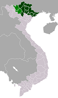
The Northeast (Đông Bắc) is the region to the north of the Red River Delta in Vietnam. It is called Northeast to distinguish it from the Northwest, but it's actually in the north and northeast of Hanoi, wider than Việt Bắc. The Northeast is one of three sub-regions of northern Vietnam (The 2 other sub-regions are the Northwest and the Red River Delta). Sometimes the Northeast includes the Red River Delta.

Geography
Location
The Northeast region encompasses the provinces northeast of Hanoi, near the border with China. It has a population of about ten million.
Geographics
Geographical boundaries to the west of the Northeast is not clear. Mainly due to the lack of consensus among the geography of Vietnam on the boundary between the Northwest and Northeast to the Red River, or should the Hoàng Liên Sơn. The Northeast is limited to the north and east by Vietnam-China border. Southeast overlooking the Gulf of Tonkin. The southern limit by Tam Đảo mountain range and the Red River Delta.
It is also mountainous in the midlands, the mountainous include massifs, and limestone mountains.
The western side, is limited by the Red River valley and the Chảy River's source, above, is composed of granite, slate and limestone plateau. In essence, this is the edge of the Yunnan Plateau. The high mountains of the Northeast are concentrated here, as Tây Côn Lĩnh, Kiêu Liêu Ti.
The northern part junction with Vietnam-China border are the plateau (highland) turns from west to east are: Bắc Hà, Quản Bạ, Đồng Văn. Two first plateau has an average elevation of 1000-1200m. Đồng Văn Plateau is 1600m. River and stream flowing through the plateau created a long and deep canyons. There are also some small plain, which is Thất Khê, Lạng Sơn, Lộc Bình, Cao Bằng.
To the east, from the Gâm River's middle into the sea, which is lower than many mountains arc turned eastward turn from east to west is the Gâm River's anticline, Ngân Sơn-Yên Lạc Bow, Bắc Sơn Massif, Đông Triều Mountain range. Mountains rising above the sea, forming the famous scenery of Hạ Long. The arc of these mountains are mostly covered tail at Tam Đảo.
Southwest, from Phú Thọ, southern Tuyên Quang, southern Yên Bái and Thái Nguyên, lower toward the plain. It is called as the "midlands". The height of this section about 100–150 m.
The Northeast has many rivers flow through, including the major river of the Red, Chảy, Lô, Gâm (the Red rivers system), Cầu, Thương, Lục Nam (in Thái Bình river system), Bằng, Bắc Giang, Kỳ Cùng...
Northeast's sea region has many large and small islands, nearly 2/3 the number of Vietnam's sea islands (including the Hoàng Sa and Trường Sa).
History
Provinces
| Province- Level Division |
Capital | Population (2019) |
Area (km²) |
|---|---|---|---|
| Bắc Giang | Bắc Giang | 1,715,000 | 3,827.4 km² |
| Bắc Kạn | Bắc Kạn | 319,000 | 4,868.4 km² |
| Cao Bằng | Cao Bằng | 529,800 | 6,724.6 km² |
| Hà Giang | Hà Giang | 891,077 | 7,945.8 km² |
| Lạng Sơn | Lạng Sơn | 759,000 | 8,331.2 km² |
| Phú Thọ | Việt Trì | 1,620,264 | 3,528.4 km² |
| Quảng Ninh | Hạ Long | 1,414,633 | 6,099.0 km² |
| Thái Nguyên | Thái Nguyên | 1,363,767 | 3.546.6 km² |
| Tuyên Quang | Tuyên Quang | 813,200 | 5,870.4 km² |
Gallery
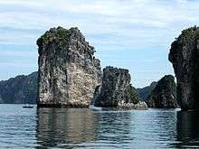 Vịnh Hạ Long
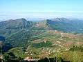 Mẫu Sơn mountains
- Rice fields in Cao Bằng
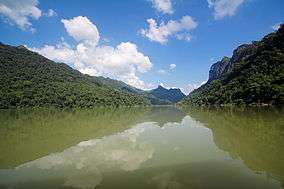 Ba Bể lake in Bắc Kạn
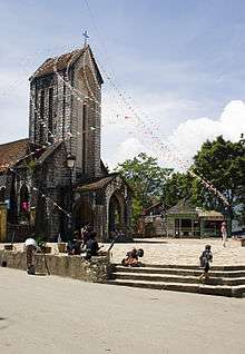 Church at Sa Pa
See also
External links
| Wikimedia Commons has media related to Đông Bắc Region (Northeast Region). |
| Bắc Giang Province | | |
|---|---|---|
| Bắc Kạn Province | ||
| Cao Bằng Province | ||
| Hà Giang Province | ||
| Lạng Sơn Province | ||
| Phú Thọ Province | ||
| Quảng Ninh Province |
| |
| Thái Nguyên Province | ||
| Tuyên Quang Province | ||
※ denotes provincial seat. | ||