Ners
Ners is a commune in the Gard department in southern France.
Ners | |
|---|---|
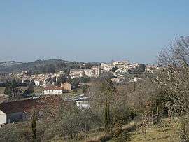 A general view of Ners | |
.svg.png) Coat of arms | |
Location of Ners 
| |
 Ners  Ners | |
| Coordinates: 44°01′38″N 4°09′34″E | |
| Country | France |
| Region | Occitanie |
| Department | Gard |
| Arrondissement | Alès |
| Canton | Quissac |
| Intercommunality | Région de Vézénobres |
| Government | |
| • Mayor (2008–2014) | Patrice Pupet |
| Area 1 | 4.96 km2 (1.92 sq mi) |
| Population (2017-01-01)[1] | 702 |
| • Density | 140/km2 (370/sq mi) |
| Time zone | UTC+01:00 (CET) |
| • Summer (DST) | UTC+02:00 (CEST) |
| INSEE/Postal code | 30188 /30360 |
| Elevation | 79–181 m (259–594 ft) (avg. 123 m or 404 ft) |
| 1 French Land Register data, which excludes lakes, ponds, glaciers > 1 km2 (0.386 sq mi or 247 acres) and river estuaries. | |
History
Ners is part of a territory inhabited long before the Roman presence in the region.
The village is located along the ancient road 'voie Régordane' going from Saint-Gilles to Puy-en-Velay. Along this road traders, pilgrims, crusaders and knights crossed the river Gardon.
In 1211 Ners is first time reported as a place of residence with the "castrum nercium" - a watchtower of the twelfth century. This tower was probably constructed as an outpost to the village of Vezenobres as well as to protect the few inhabitants of the village. The tower was gradually expanded and in 1480 it retained its castle walls and is to be considered the oldest building in the village.
Etymology
Etymologically the name can be derived from "Nertius", a Gallo-Roman person with great prestige in ancient times. A manuscript from 1247 mentions the name "Nercium" and in 1547 "Ners".
Population
| Historical population | ||
|---|---|---|
| Year | Pop. | ±% |
| 1789 | 425 | — |
| 1856 | 561 | +32.0% |
| 1901 | 403 | −28.2% |
| 1954 | 354 | −12.2% |
| 1962 | 347 | −2.0% |
| 1968 | 357 | +2.9% |
| 1975 | 362 | +1.4% |
| 1982 | 473 | +30.7% |
| 1990 | 544 | +15.0% |
| 1999 | 618 | +13.6% |
| 2008 | 672 | +8.7% |
References
- "Populations légales 2017". INSEE. Retrieved 6 January 2020.
| Wikimedia Commons has media related to Ners. |
| Authority control |
|
|---|