National Register of Historic Places listings in Shiawassee County, Michigan
The following is a list of Registered Historic Places in Shiawassee County, Michigan.
- This National Park Service list is complete through NPS recent listings posted June 19, 2020.[1]
| [2] | Name on the Register[3] | Image | Date listed[4] | Location | City or town | Description |
|---|---|---|---|---|---|---|
| 1 | Nathan Ayres House |  Nathan Ayres House |
November 4, 1980 (#80001891) |
604 N. Water St. 43°00′11″N 84°10′23″W |
Owosso | |
| 2 | Byron Historic Commercial District |  Byron Historic Commercial District |
September 13, 1984 (#84001848) |
Roughly Saginaw St. from Maple to Water Sts. 42°49′20″N 83°56′39″W |
Byron | |
| 3 | Charles H. Calkins House |  Charles H. Calkins House |
March 29, 1978 (#78001511) |
127 E. 1st St. 42°49′27″N 84°13′05″W |
Perry | |
| 4 | Leigh Christian House |  Leigh Christian House |
November 4, 1980 (#80001892) |
622 N. Ball St. 43°00′13″N 84°10′19″W |
Owosso | |
| 5 | Christian-Ellis House |  Christian-Ellis House |
November 4, 1980 (#80001893) |
600 N. Water St. 43°00′10″N 84°10′23″W |
Owosso | |
| 6 | Hezekiah W. and Sarah E. Fishell Cobb House |  Hezekiah W. and Sarah E. Fishell Cobb House |
April 11, 1997 (#97000281) |
115 W. 2nd St. 42°49′29″N 84°13′12″W |
Perry | |
| 7 | Elias Comstock Cabin | 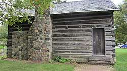 Elias Comstock Cabin |
November 4, 1980 (#80001894) |
Curwood Castle Dr., and John St. 42°59′57″N 84°10′32″W |
Owosso | |
| 8 | Corunna High School |  Corunna High School |
March 13, 2017 (#100000748) |
106 S. Shiawassee St. 42°58′46″N 84°07′07″W |
Corunna | |
| 9 | Curwood Castle | 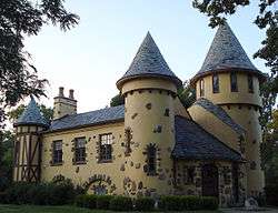 Curwood Castle |
September 3, 1971 (#71000420) |
224 John St. 42°59′34″N 84°10′31″W |
Owosso | |
| 10 | Duff Building |  Duff Building |
January 31, 1985 (#85000168) |
118 W. Exchange St 42°59′56″N 84°10′18″W |
Owosso | |
| 11 | Durand High School |  Durand High School |
March 17, 2009 (#09000130) |
100 West Sycamore Street 42°54′55″N 83°59′11″W |
Durand | |
| 12 | Frederick Frieseke Birthplace and Boyhood Home |  Frederick Frieseke Birthplace and Boyhood Home |
November 4, 1980 (#80001895) |
654 N. Water St. 43°00′15″N 84°10′23″W |
Owosso | |
| 13 | Julius Frieseke House |  Julius Frieseke House |
April 5, 1990 (#90000574) |
529 Corunna Ave. 42°59′30″N 84°09′51″W |
Owosso | |
| 14 | Amos Gould House |  Amos Gould House |
November 4, 1980 (#80001896) |
115 W. King St. 43°00′16″N 84°10′18″W |
Owosso | |
| 15 | Daniel Gould House | 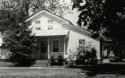 Daniel Gould House |
November 4, 1980 (#80001897) |
509 E. Main St. 42°59′52″N 84°09′51″W |
Owosso | Building no longer exists. |
| 16 | Ebenezer Gould House |  Ebenezer Gould House |
November 4, 1980 (#80001898) |
orig. 603 W. Main St. now: 42°59′01″N 84°07′38″W |
Owosso | Building relocated to historic/museum village in nearby Corunna. |
| 17 | Grand Trunk Railway Station |  Grand Trunk Railway Station |
May 6, 1971 (#71000419) |
200 Railroad St. 42°54′33″N 83°58′57″W |
Durand | |
| 18 | Grow Block |  Grow Block |
January 31, 1985 (#85000169) |
120-122 W. Exchange St. 42°59′56″N 84°10′18″W |
Owosso | |
| 19 | William Horton Farmhouse | 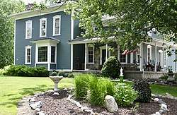 William Horton Farmhouse |
April 10, 1986 (#86000711) |
1647 W. Miller Rd. 42°51′49″N 84°11′52″W |
Morrice | |
| 20 | House at 314 W. King St. |  House at 314 W. King St. |
November 4, 1980 (#80001899) |
314 W. King St. 43°00′18″N 84°10′26″W |
Owosso | Replaced by a newer house at the same address. |
| 21 | John N. Ingersoll House |  John N. Ingersoll House |
May 9, 1980 (#80001890) |
570 W. Corunna Ave. 42°58′57″N 84°07′35″W |
Corunna | |
| 22 | Eugene Jacobs House |  Eugene Jacobs House |
November 4, 1980 (#80004553) |
220 W. King St. 43°00′18″N 84°10′23″W |
Owosso | |
| 23 | Lincoln School |  Lincoln School |
August 8, 2016 (#16000510) |
120 Michigan Ave. 42°59′50″N 84°10′29″W |
Owosso | |
| 24 | Martin Road Bridge |  Martin Road Bridge |
July 12, 1991 (#91000876) |
Martin Rd. across the Shiawassee River, Caledonia Township 42°58′08″N 84°03′21″W |
Corunna | In 2016, the bridge was disassembled and removed by Bach Steel. Renovation is underway, and it will be re-assembled at the Auburn Heights Preserve in Yorklyn, Delaware.[5] |
| 25 | Mason Street Historic Residential District | 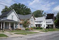 Mason Street Historic Residential District |
November 4, 1980 (#80001900) |
Roughly bounded by Laverock Alley, Dewey, Hickory and Exchange Sts. 42°59′57″N 84°09′54″W |
Owosso | |
| 26 | Colin McCormick House |  Colin McCormick House |
November 4, 1980 (#80001901) |
222 E. Exchange St. 42°59′53″N 84°10′06″W |
Owosso | |
| 27 | Michigan Avenue-Genessee Street Historic Residential District |  Michigan Avenue-Genessee Street Historic Residential District |
November 4, 1980 (#80001902) |
Roughly bounded by Michigan Ave.; Shiawassee, Cass and Clinton Sts. 42°59′43″N 84°10′32″W |
Owosso | |
| 28 | Selden Miner House |  Selden Miner House |
November 4, 1980 (#80001903) |
418 W. King St. 43°00′18″N 84°10′32″W |
Owosso | |
| 29 | Old Miller Hospital |  Old Miller Hospital |
November 4, 1980 (#80001904) |
121 Michigan Ave. 42°59′48″N 84°10′29″W |
Owosso | |
| 30 | Oliver Street Historic District |  Oliver Street Historic District |
November 4, 1980 (#80001905) |
Oliver St. between 3rd and Oak Sts., Williams and Goodhue Sts. 43°00′06″N 84°10′24″W |
Owosso | |
| 31 | Sylvester Opdyke House |  Sylvester Opdyke House |
November 4, 1980 (#80001906) |
655 N. Pine St. 43°00′16″N 84°10′33″W |
Owosso | |
| 32 | Owosso Downtown Historic District |  Owosso Downtown Historic District |
April 7, 2014 (#14000126) |
Roughly bounded by Shiawassee R., Comstock, Water, Park and Mason Sts. 42°59′53″N 84°10′14″W |
Owosso | |
| 33 | Albert Palmer House |  Albert Palmer House |
November 4, 1980 (#80001907) |
528-530 River St. 42°59′58″N 84°10′43″W |
Owosso | |
| 34 | George Pardee House |  George Pardee House |
November 4, 1980 (#80001908) |
603 N. Ball St. 43°00′10″N 84°10′20″W |
Owosso | |
| 35 | Pere Marquette Railway Steam Locomotive No. 1225 |  Pere Marquette Railway Steam Locomotive No. 1225 |
July 31, 1994 (#94000744) |
600 S. Oakwood St. 42°59′35″N 84°09′53″W |
Owosso | |
| 36 | George Perrigo House |  George Perrigo House |
November 4, 1980 (#80001909) |
213 N. Cedar St. 42°59′56″N 84°10′55″W |
Owosso | |
| 37 | Shiawassee County Courthouse | 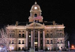 Shiawassee County Courthouse |
November 12, 1982 (#82000546) |
Shiawassee St. 42°58′53″N 84°07′02″W |
Corunna | see Claire Allen for more info |
| 38 | Edwin Todd House |  Edwin Todd House |
November 4, 1980 (#80001910) |
520 N. Adams St. 43°00′10″N 84°10′28″W |
Owosso | |
| 39 | West Town Historic Commercial and Industrial District |  West Town Historic Commercial and Industrial District |
November 4, 1980 (#80001911) |
Main St. 42°59′55″N 84°11′02″W |
Owosso | |
| 40 | Alfred Williams House |  Alfred Williams House |
November 4, 1980 (#80001912) |
611 N. Ball St. 43°00′12″N 84°10′20″W |
Owosso | |
| 41 | Benjamin Williams House |  Benjamin Williams House |
November 4, 1980 (#80001913) |
628 N. Ball St. 43°00′14″N 84°10′19″W |
Owosso | |
| 42 | Williams-Cole House |  Williams-Cole House |
December 4, 1986 (#86003418) |
6810 Newburg Rd. 42°54′35″N 84°01′49″W |
Durand | |
| 43 | Lee Woodard and Sons Building |  Lee Woodard and Sons Building |
November 4, 1980 (#80001914) |
306 S. Elm St. 42°59′42″N 84°10′42″W |
Owosso | |
| 44 | Lyman Woodard Company Workers' Housing |  Lyman Woodard Company Workers' Housing |
November 4, 1980 (#80001916) |
601 Clinton St. 42°59′47″N 84°10′43″W |
Owosso | |
| 45 | Lyman Woodard Furniture and Casket Company Building |  Lyman Woodard Furniture and Casket Company Building |
November 4, 1980 (#80001915) |
216-222 Elm St. 42°59′44″N 84°10′43″W |
Owosso |
See also
| Wikimedia Commons has media related to National Register of Historic Places in Shiawassee County, Michigan. |
- National Register of Historic Places listings in Michigan
- List of Michigan State Historic Sites in Shiawassee County, Michigan
References
- "National Register of Historic Places: Weekly List Actions". National Park Service, United States Department of the Interior. Retrieved on June 19, 2020.
- Numbers represent an ordering by significant words. Various colorings, defined here, differentiate National Historic Landmarks and historic districts from other NRHP buildings, structures, sites or objects.
- "National Register Information System". National Register of Historic Places. National Park Service. April 24, 2008.
- The eight-digit number below each date is the number assigned to each location in the National Register Information System database, which can be viewed by clicking the number.
- "Martin Road Bridge". Historic Bridges.org. Retrieved November 30, 2018.
| Lists by county |
|  |
|---|---|---|
| Other lists |
| |
| Topics | |
|---|---|
| Lists by state |
|
| Lists by insular areas | |
| Lists by associated state | |
| Other areas | |
| Related | |
| |
This article is issued from Wikipedia. The text is licensed under Creative Commons - Attribution - Sharealike. Additional terms may apply for the media files.