National Register of Historic Places listings in Ramsey County, North Dakota
This is a list of the National Register of Historic Places listings in Ramsey County, North Dakota.

Location of Ramsey County in North Dakota
This is intended to be a complete list of the properties and districts on the National Register of Historic Places in Ramsey County, North Dakota, United States. The locations of National Register properties and districts for which the latitude and longitude coordinates are included below, may be seen in a map.[1]
There are 15 properties and districts listed on the National Register in the county.
| Adams | Barnes | Benson | Billings | Bottineau | Bowman | Burke | Burleigh | Cass | Cavalier | Dickey | Divide | Dunn | Eddy | Emmons | Foster | Golden Valley | Grand Forks | Grant | Griggs | Hettinger | Kidder | La Moure | Logan | McHenry | McIntosh | McKenzie | McLean | Mercer | Morton | Mountrail | Nelson | Oliver | Pembina | Pierce | Ramsey | Ransom | Renville | Richland | Rolette | Sargent | Sheridan | Sioux | Slope | Stark | Steele | Stutsman | Towner | Traill | Walsh | Ward | Wells | Williams |
- This National Park Service list is complete through NPS recent listings posted June 19, 2020.[2]
Current listings
| [3] | Name on the Register[4] | Image | Date listed[5] | Location | City or town | Description |
|---|---|---|---|---|---|---|
| 1 | Bangs-Wineman Block | 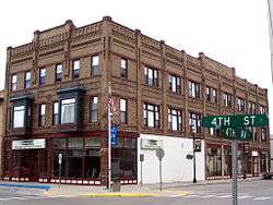 Bangs-Wineman Block |
November 14, 1985 (#85002797) |
402-408 4th St. 48°07′14″N 98°51′35″W |
Devils Lake | |
| 2 | Central High School |  Central High School |
December 29, 2003 (#03000871) |
325 7th St. NE 48°06′55″N 98°51′37″W |
Devils Lake | |
| 3 | Devils Lake Carnegie Library | 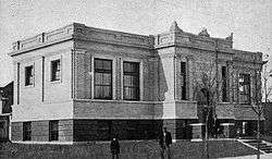 Devils Lake Carnegie Library |
March 6, 2002 (#02000132) |
623 4th Ave. 48°06′53″N 98°51′37″W |
Devils Lake | |
| 4 | Devils Lake Commercial District | 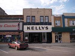 Devils Lake Commercial District |
October 24, 1989 (#89001675) |
Roughly bounded by 2nd Ave., 5th St., 5th Ave., 3rd St., and Railroad Ave. 48°06′44″N 98°51′36″W |
Devils Lake | |
| 5 | Devils Lake Masonic Temple | 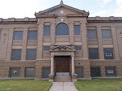 Devils Lake Masonic Temple |
September 1, 2001 (#01000923) |
403 6th St. 48°06′50″N 98°48′33″W |
Devils Lake | |
| 6 | Episcopal Church of the Advent-Guild Hall | June 20, 2002 (#02000669) |
501 6th St., E. 48°06′51″N 98°51′29″W |
Devils Lake | ||
| 7 | Locke Block | 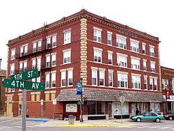 Locke Block |
July 24, 1986 (#86001915) |
405 5th St. 48°06′45″N 98°51′34″W |
Devils Lake | |
| 8 | Methodist Episcopal Church | July 16, 2008 (#08000680) |
601 5th St., NE. 48°06′46″N 98°51′26″W |
Devils Lake | ||
| 9 | Newport Apartments | 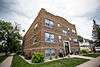 Newport Apartments |
July 11, 1988 (#88000985) |
601 7th St. 48°06′54″N 98°50′36″W |
Devils Lake | |
| 10 | Ramsey County Sheriff's House |  Ramsey County Sheriff's House |
January 31, 1978 (#78003452) |
420 6th St. 48°06′50″N 98°51′36″W |
Devils Lake | |
| 11 | St. Mary's Academy | 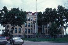 St. Mary's Academy |
February 24, 1983 (#83001939) |
E. 7th St. 48°06′55″N 98°50′52″W |
Devils Lake | |
| 12 | St. Olaf Lutheran Church | March 23, 2015 (#15000106) |
601 6th St., NE. 48°06′50″N 98°51′24″W |
Devils Lake | ||
| 13 | Sons of Jacob Cemetery | June 5, 2017 (#100001035) |
88th Ave. NE, 0.25 miles (0.40 km) north of 67th St. NE 48°23′21″N 98°45′28″W |
Garske vicinity | Cemetery of Garske Colony, a Jewish farming community which existed from 1883 to about 1920.[6] | |
| 14 | U.S. Post Office and Courthouse | 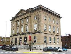 U.S. Post Office and Courthouse |
June 22, 1978 (#78001993) |
502 4th St. 48°06′42″N 98°51′29″W |
Devils Lake | |
| 15 | Westminster Presbyterian Church |  Westminster Presbyterian Church |
July 16, 2008 (#08000679) |
501 5th St., NE. 48°06′47″N 98°51′31″W |
Devils Lake |
See also
| Wikimedia Commons has media related to National Register of Historic Places in Ramsey County, North Dakota. |
References
- The latitude and longitude information provided in this table was derived originally from the National Register Information System, which has been found to be fairly accurate for about 99% of listings. Some locations in this table may have been corrected to current GPS standards.
- "National Register of Historic Places: Weekly List Actions". National Park Service, United States Department of the Interior. Retrieved on June 19, 2020.
- Numbers represent an ordering by significant words. Various colorings, defined here, differentiate National Historic Landmarks and historic districts from other NRHP buildings, structures, sites or objects.
- "National Register Information System". National Register of Historic Places. National Park Service. July 9, 2010.
- The eight-digit number below each date is the number assigned to each location in the National Register Information System database, which can be viewed by clicking the number.
- Garske Colony
| Topics | |
|---|---|
| Lists by state |
|
| Lists by insular areas | |
| Lists by associated state | |
| Other areas | |
| Related | |
| |
Municipalities and communities of Ramsey County, North Dakota, United States | ||
|---|---|---|
| Cities | Map of North Dakota highlighting Ramsey County | |
| Townships |
| |
| Unincorporated communities | ||
This article is issued from Wikipedia. The text is licensed under Creative Commons - Attribution - Sharealike. Additional terms may apply for the media files.