National Register of Historic Places listings in Narragansett, Rhode Island
This is a list of Registered Historic Places in Narragansett, Rhode Island.
Bristol | Kent | Newport | Providence | Washington |
- This National Park Service list is complete through NPS recent listings posted June 19, 2020.[1]
| [2] | Name on the Register[3] | Image | Date listed[4] | Location | City or town | Description |
|---|---|---|---|---|---|---|
| 1 | Anthony-Kinney Farm | 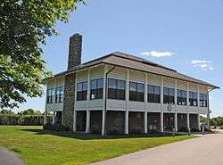 Anthony-Kinney Farm |
April 17, 2013 (#13000178) |
505 Point Judith Road 41°24′26″N 71°28′44″W |
Narragansett | |
| 2 | Central Street Historic District | 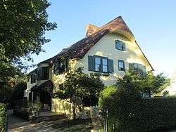 Central Street Historic District |
August 18, 1982 (#82000015) |
Both sides of Central Street from 5th Ave. to Boon St. 41°25′46″N 71°27′44″W |
Narragansett | |
| 3 | Druidsdream | 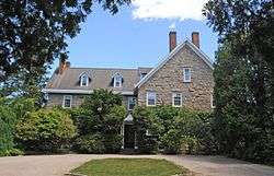 Druidsdream |
July 20, 1989 (#89000940) |
144 Gibson Ave. 41°25′02″N 71°27′46″W |
Narragansett | |
| 4 | The Dunes Club | .jpg) The Dunes Club |
May 18, 2015 (#15000243) |
137 Boston Neck Rd. 41°26′23″N 71°26′56″W |
Narragansett | |
| 5 | Dunmere | 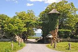 Dunmere |
September 23, 2005 (#05001061) |
560 Ocean Rd. 41°24′16″N 71°27′44″W |
Narragansett | |
| 6 | Earlscourt Historic District | 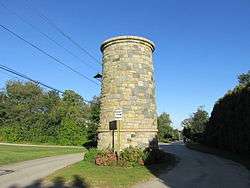 Earlscourt Historic District |
August 18, 1982 (#82000017) |
Roughly bounded by Westmoreland, Noble, Woodward Sts., and Gibson Ave.(both sides) 41°25′15″N 71°27′42″W |
Narragansett | |
| 7 | Gardencourt | 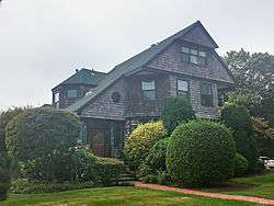 Gardencourt |
August 18, 1982 (#82000018) |
10 Gibson Ave. 41°25′21″N 71°27′39″W |
Narragansett | |
| 8 | Gladstone Springhouse and Bottling Plant | 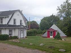 Gladstone Springhouse and Bottling Plant |
May 10, 1984 (#84002051) |
145A Boon St. 41°25′35″N 71°27′25″W |
Narragansett | |
| 9 | Greene Inn | .jpg) Greene Inn |
June 24, 1976 (#76000009) |
175 Ocean Rd. 41°25′23″N 71°27′23″W |
Narragansett | Burned down in 1980. |
| 10 | Narragansett Baptist Church | 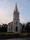 Narragansett Baptist Church |
November 25, 1977 (#77000010) |
S. Ferry Rd. 41°29′34″N 71°25′34″W |
Narragansett | |
| 11 | Narragansett Pier Life Saving Station | 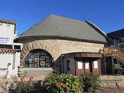 Narragansett Pier Life Saving Station |
June 30, 1976 (#76000010) |
40 Ocean Rd. 41°25′48″N 71°27′20″W |
Narragansett | |
| 12 | Ocean Road Historic District | 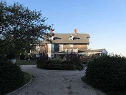 Ocean Road Historic District |
August 18, 1982 (#82000019) |
Ocean and Wildfield Farm Rds., and Newton and Hazard Aves. 41°24′45″N 71°27′22″W |
Narragansett | |
| 13 | Point Judith Lighthouse | 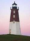 Point Judith Lighthouse |
March 30, 1988 (#88000279) |
1470 Ocean Rd. 41°21′39″N 71°28′55″W |
Narragansett | |
| 14 | Towers Historic District | 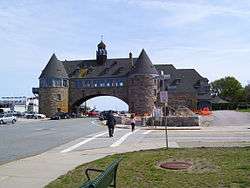 Towers Historic District |
August 18, 1982 (#82000021) |
Bounded by the Atlantic Ocean, Exchange Pl., and Mathewson and Taylor Sts. 41°25′48″N 71°27′23″W |
Narragansett | |
| 15 | The Towers | The Towers |
November 25, 1969 (#69000001) |
Ocean Rd. 41°25′50″N 71°27′22″W |
Narragansett |
See also
References
- "National Register of Historic Places: Weekly List Actions". National Park Service, United States Department of the Interior. Retrieved on June 19, 2020.
- Numbers represent an ordering by significant words. Various colorings, defined here, differentiate National Historic Landmarks and historic districts from other NRHP buildings, structures, sites or objects.
- "National Register Information System". National Register of Historic Places. National Park Service. March 13, 2009.
- The eight-digit number below each date is the number assigned to each location in the National Register Information System database, which can be viewed by clicking the number.
| Topics | _(extra_close)_(US48).svg.png) | ||||||||||
|---|---|---|---|---|---|---|---|---|---|---|---|
| Lists by county | |||||||||||
| Lists by city |
| ||||||||||
| |||||||||||
This article is issued from Wikipedia. The text is licensed under Creative Commons - Attribution - Sharealike. Additional terms may apply for the media files.