National Register of Historic Places listings in McCook County, South Dakota
This is a list of the National Register of Historic Places listings in McCook County, South Dakota.
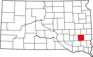
Location of McCook County in South Dakota
This is intended to be a complete list of the properties and districts on the National Register of Historic Places in McCook County, South Dakota, United States. The locations of National Register properties and districts for which the latitude and longitude coordinates are included below, may be seen in a map.[1]
There are 11 properties and districts listed on the National Register in the county.
- This National Park Service list is complete through NPS recent listings posted June 19, 2020.[2]
Current listings
| [3] | Name on the Register[4] | Image | Date listed[5] | Location | City or town | Description |
|---|---|---|---|---|---|---|
| 1 | Archeological Site No. 39MK12 | August 6, 1993 (#93000796) |
Address Restricted |
Bridgewater | ||
| 2 | Downtown Salem Historic District | 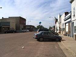 Downtown Salem Historic District |
January 28, 2004 (#03001527) |
140, 200, and 201 N. Main 43°43′31″N 97°23′24″W |
Salem | |
| 3 | First Presbyterian Church | December 11, 2013 (#13000917) |
351 N. Poplar 43°33′05″N 97°30′04″W |
Bridgewater | ||
| 4 | Henry Kuhle House |  Henry Kuhle House |
January 16, 2008 (#08000053) |
321 E. Washington 43°43′51″N 97°23′06″W |
Salem | |
| 5 | McCook County Courthouse | 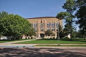 McCook County Courthouse |
February 10, 1993 (#92001862) |
130 W. Essex Ave. 43°43′41″N 97°23′15″W |
Salem | |
| 6 | Ortman Hotel | February 21, 1997 (#97000144) |
201 W. Main St. 43°35′52″N 97°17′28″W |
Canistota | ||
| 7 | St. Mary's Catholic Church | 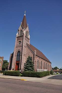 St. Mary's Catholic Church |
June 19, 1985 (#85001354) |
Vermont and Idaho Sts. 43°43′36″N 97°23′22″W |
Salem | |
| 8 | Salem Rest Stop Tipi-Eastbound | 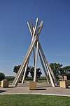 Salem Rest Stop Tipi-Eastbound |
January 20, 2015 (#14001181) |
Mi. 362.2 on I-90 43°39′57″N 97°25′20″W |
Salem vicinity | |
| 9 | Salem Rest Stop Tipi-Westbound | 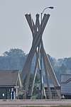 Salem Rest Stop Tipi-Westbound |
January 20, 2015 (#14001182) |
Mi. 362.7 on I-90 43°40′02″N 97°24′54″W |
Salem vicinity | |
| 10 | South Dakota Dept. of Transportation Bridge No. 44-212-090 | December 9, 1993 (#93001302) |
Local road over the East Fork of the Vermillion River 43°42′59″N 97°11′14″W |
Montrose | ||
| 11 | Stark Round Barn | June 6, 2001 (#01000637) |
Southern side of 247th St, 0.1 miles east of the former Chicago and Northwestern railroad line 43°48′14″N 97°27′04″W |
Unityville |
See also
| Wikimedia Commons has media related to National Register of Historic Places in McCook County, South Dakota. |
References
- The latitude and longitude information provided in this table was derived originally from the National Register Information System, which has been found to be fairly accurate for about 99% of listings. Some locations in this table may have been corrected to current GPS standards.
- "National Register of Historic Places: Weekly List Actions". National Park Service, United States Department of the Interior. Retrieved on June 19, 2020.
- Numbers represent an ordering by significant words. Various colorings, defined here, differentiate National Historic Landmarks and historic districts from other NRHP buildings, structures, sites or objects.
- "National Register Information System". National Register of Historic Places. National Park Service. April 24, 2008.
- The eight-digit number below each date is the number assigned to each location in the National Register Information System database, which can be viewed by clicking the number.
| Topics | |
|---|---|
| Lists by state |
|
| Lists by insular areas | |
| Lists by associated state | |
| Other areas | |
| Related | |
| |
Municipalities and communities of McCook County, South Dakota, United States | ||
|---|---|---|
| Cities | | |
| Unincorporated community | ||
This article is issued from Wikipedia. The text is licensed under Creative Commons - Attribution - Sharealike. Additional terms may apply for the media files.