Montrose, South Dakota
Montrose is a city in McCook County, South Dakota, United States. The population was 472 at the 2010 census.
Montrose, South Dakota | |
|---|---|
| Motto(s): "What You Need When You Need It" | |
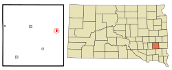 Location in McCook County and the state of South Dakota | |
| Coordinates: 43°41′58″N 97°11′9″W | |
| Country | United States |
| State | South Dakota |
| County | McCook |
| Platted | 1880[1] |
| Area | |
| • Total | 0.41 sq mi (1.07 km2) |
| • Land | 0.41 sq mi (1.07 km2) |
| • Water | 0.00 sq mi (0.00 km2) |
| Elevation | 1,470 ft (448 m) |
| Population | |
| • Total | 472 |
| • Estimate (2018)[4] | 443 |
| • Density | 1,075.24/sq mi (415.25/km2) |
| Time zone | UTC-6 (Central (CST)) |
| • Summer (DST) | UTC-5 (CDT) |
| ZIP code | 57048 |
| Area code(s) | 605 |
| FIPS code | 46-43500 |
| GNIS feature ID | 1256529[5] |
| Website | http://www.cityofmontrosesd.com/ |
History
Montrose was laid out in 1880.[6] Some say the town was named after the novel A Legend of Montrose by Sir Walter Scott,[6] while others believe the name is an amalgamation of "mountain" and "rose", features near the original town site.[7] A post office has been in operation in Montrose since 1880.[8]
Geography
Montrose is located at 43°41′58″N 97°11′9″W (43.699453, -97.185858).[9]
According to the United States Census Bureau, the city has a total area of 0.41 square miles (1.06 km2), all of it land.[10]
Montrose has been assigned the ZIP code 57048 and the FIPS place code 43500.
Demographics
| Historical population | |||
|---|---|---|---|
| Census | Pop. | %± | |
| 1890 | 563 | — | |
| 1900 | 375 | −33.4% | |
| 1910 | 442 | 17.9% | |
| 1920 | 519 | 17.4% | |
| 1930 | 471 | −9.2% | |
| 1940 | 506 | 7.4% | |
| 1950 | 448 | −11.5% | |
| 1960 | 430 | −4.0% | |
| 1970 | 377 | −12.3% | |
| 1980 | 396 | 5.0% | |
| 1990 | 420 | 6.1% | |
| 2000 | 460 | 9.5% | |
| 2010 | 472 | 2.6% | |
| Est. 2018 | 443 | [4] | −6.1% |
| U.S. Decennial Census[11] | |||
2010 census
As of the census[3] of 2010, there were 472 people, 191 households, and 135 families residing in the city. The population density was 1,151.2 inhabitants per square mile (444.5/km2). There were 208 housing units at an average density of 507.3 per square mile (195.9/km2). The racial makeup of the city was 97.7% White, 1.1% from other races, and 1.3% from two or more races. Hispanic or Latino of any race were 2.3% of the population.
There were 191 households of which 35.1% had children under the age of 18 living with them, 59.2% were married couples living together, 8.9% had a female householder with no husband present, 2.6% had a male householder with no wife present, and 29.3% were non-families. 26.2% of all households were made up of individuals and 14.7% had someone living alone who was 65 years of age or older. The average household size was 2.47 and the average family size was 2.99.
The median age in the city was 37.2 years. 27.8% of residents were under the age of 18; 5% were between the ages of 18 and 24; 28.2% were from 25 to 44; 22.4% were from 45 to 64; and 16.5% were 65 years of age or older. The gender makeup of the city was 46.6% male and 53.4% female.
2000 census
As of the census of 2000, there were 460 people, 195 households, and 124 families residing in the city. The population density was 1,133.7 people per square mile (433.2/km²). There were 202 housing units at an average density of 497.8 per square mile (190.2/km²). The racial makeup of the city was 98.70% White, 0.87% Native American, 0.43% from other races. Hispanic or Latino of any race were 1.09% of the population.
There were 195 households out of which 26.7% had children under the age of 18 living with them, 53.8% were married couples living together, 6.2% had a female householder with no husband present, and 35.9% were non-families. 31.3% of all households were made up of individuals and 17.4% had someone living alone who was 65 years of age or older. The average household size was 2.36 and the average family size was 2.98.
In the city, the population was spread out with 25.0% under the age of 18, 8.3% from 18 to 24, 28.9% from 25 to 44, 18.3% from 45 to 64, and 19.6% who were 65 years of age or older. The median age was 36 years. For every 100 females, there were 88.5 males. For every 100 females age 18 and over, there were 88.5 males.
The median income for a household in the city was $31,250, and the median income for a family was $39,583. Males had a median income of $30,385 versus $19,886 for females. The per capita income for the city was $15,233. About 3.5% of families and 11.8% of the population were below the poverty line, including 8.5% of those under age 18 and 18.9% of those age 65 or over.
Porter Sculpture Park
The Porter Sculpture Park is located outside the Montrose community, not far from I-90. Inside the park there sit 50 giant metal creatures designed by welding extra metal junk together. Of these 50 there is a 60-foot-tall (18 m) longhorn, a giant pink rocking horse, and a magic dragon. It is an example of one man's view of the world.
References
- "SD Towns" (PDF). South Dakota State Historical Society. Retrieved 2010-02-14.
- "2018 U.S. Gazetteer Files". United States Census Bureau. Retrieved February 22, 2020.
- "U.S. Census website". United States Census Bureau. Retrieved 2012-06-21.
- "Population and Housing Unit Estimates". United States Census Bureau. June 27, 2019. Retrieved June 4, 2019.
- "US Board on Geographic Names". United States Geological Survey. 2007-10-25. Retrieved 2008-01-31.
- Chicago and North Western Railway Company (1908). A History of the Origin of the Place Names Connected with the Chicago & North Western and Chicago, St. Paul, Minneapolis & Omaha Railways. p. 184.
- Federal Writers' Project (1940). South Dakota place-names, v.1-3. University of South Dakota. p. 52.
- "McCook County". Jim Forte Postal History. Retrieved 4 April 2015.
- "US Gazetteer files: 2010, 2000, and 1990". United States Census Bureau. 2011-02-12. Retrieved 2011-04-23.
- "US Gazetteer files 2010". United States Census Bureau. Archived from the original on 2012-07-02. Retrieved 2012-06-21.
- United States Census Bureau. "Census of Population and Housing". Retrieved September 23, 2013.
| Wikimedia Commons has media related to Porter Sculpture Park. |
Municipalities and communities of McCook County, South Dakota, United States | ||
|---|---|---|
| Cities | 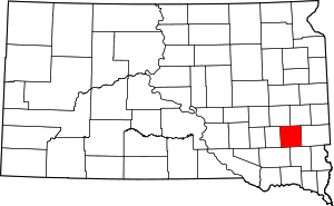 | |
| Unincorporated community | ||
| Authority control |
|
|---|