National Register of Historic Places listings in Contra Costa County, California
This is a list of the National Register of Historic Places listings in Contra Costa County, California.
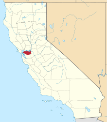
Location of Contra Costa County in California
This is intended to be a complete list of the properties and districts on the National Register of Historic Places in Contra Costa County, California, United States. Latitude and longitude coordinates are provided for many National Register properties and districts; these locations may be seen together in an online map.[1]
There are 47 properties and districts listed on the National Register in the county, including 1 National Historic Landmark.
- This National Park Service list is complete through NPS recent listings posted June 19, 2020.[2]
Current listings
| [3] | Name on the Register[4] | Image | Date listed[5] | Location | City or town | Description |
|---|---|---|---|---|---|---|
| 1 | Alvarado Park | Alvarado Park |
April 9, 1992 (#92000313) |
Jct. of Marin and Park Aves. 37°57′10″N 122°19′10″W |
Richmond | |
| 2 | Atchison Village Defense Housing Project, Cal. 4171-x | .jpg) Atchison Village Defense Housing Project, Cal. 4171-x |
May 30, 2003 (#03000473) |
Roughly bounded by MacDonald Ave., Ohio St., First St., and Garrard Blvd. 37°55′58″N 122°22′12″W |
Richmond | Atchison Village page at Rosie the Riveter Trust website with information about its history. The page also includes a link to the NRHP nomination form. |
| 3 | Bank of Pinole | .JPG) Bank of Pinole |
October 24, 1996 (#96001175) |
2361 San Pablo Ave. 38°00′20″N 122°17′25″W |
Pinole | |
| 4 | Black Diamond Mines | .JPG) Black Diamond Mines |
October 2, 1991 (#91001425) |
Somersville Rd. southeast of Antioch 37°57′01″N 121°51′25″W |
Antioch | |
| 5 | Borland House | 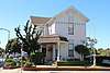 Borland House |
April 2, 2015 (#15000120) |
1005 Escobar St. 38°01′09″N 122°08′05″W |
Martinez | First property listed under the Multiple Property Submission "Historic Resources of Martinez, California" also accepted to the National Register of Historic Places April 2015. |
| 6 | Maynard and Katharine Buehler House | .JPG) Maynard and Katharine Buehler House |
December 12, 2006 (#06001118) |
6 Great Oak Circle 37°51′47″N 122°10′09″W |
Orinda | Frank Lloyd Wright house |
| 7 | CA-CCO-548 | CA-CCO-548 |
September 25, 2012 (#12000808) |
Marsh Creek State Historic Park 37°53′27″N 121°43′22″W |
Brentwood | Prehistoric Native American habitation & burial site (CA-CCO-15/548). |
| 8 | Clayton Vineyards-DeMartini Winery | .JPG) Clayton Vineyards-DeMartini Winery |
August 30, 1984 (#84000767) |
5919 Clayton Rd. 37°56′35″N 121°56′11″W |
Clayton | |
| 9 | Contra Costa County Courthouse Block | .jpg) Contra Costa County Courthouse Block |
December 28, 1989 (#89002113) |
625 Court St. 38°01′07″N 122°08′04″W |
Martinez | The original courthouse building at 625 Court St. is now the Contra Costa County Finance Building |
| 10 | Contra Costa County Hall of Records | Contra Costa County Hall of Records |
September 13, 1991 (#91001385) |
725 Court St. 38°01′07″N 122°07′55″W |
Martinez | Now the Contra Costa County Courthouse |
| 11 | Danville Southern Pacific Railroad Depot | .JPG) Danville Southern Pacific Railroad Depot |
August 16, 1994 (#94000860) |
355 Railroad Ave. 37°49′15″N 122°00′02″W |
Danville | |
| 12 | Robert Stanley Dollar Sr. House |  Robert Stanley Dollar Sr. House |
July 9, 2013 (#13000472) |
1015 Stanley Dollar Dr. 37°51′44″N 122°04′03″W |
Walnut Creek | |
| 13 | East Brother Island Light Station | .JPG) East Brother Island Light Station |
February 12, 1971 (#71000138) |
On East Brother Island west of Point San Pablo 37°57′48″N 122°25′57″W |
Richmond | |
| 14 | Bernardo Fernandez House | .JPG) Bernardo Fernandez House |
April 11, 1973 (#73000399) |
100 Tennent Ave. 38°00′40″N 122°17′45″W |
Pinole | |
| 15 | Ford Motor Company Assembly Plant | Ford Motor Company Assembly Plant |
June 23, 1988 (#88000919) |
1414-1422 Harbour Way, S. 37°54′40″N 122°21′22″W |
Richmond | |
| 16 | Forest Home Farms | 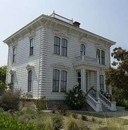 Forest Home Farms |
June 28, 2002 (#02000677) |
19953 San Ramon Valley Blvd. 37°44′06″N 121°57′00″W |
San Ramon | |
| 17 | Don Francisco Galindo House | .JPG) Don Francisco Galindo House |
May 20, 1988 (#88000553) |
1721 Amador Ave. 37°58′24″N 122°02′05″W |
Concord | |
| 18 | Roswell Butler Hard House | .JPG) Roswell Butler Hard House |
September 30, 1993 (#93001020) |
815 W. First St. 38°01′03″N 121°49′00″W |
Antioch | Antioch Press article about the Hard House |
| 19 | William T. Hendrick House | .JPG) William T. Hendrick House |
September 8, 1983 (#83001176) |
218 Center Ave. 37°59′01″N 122°04′12″W |
Pacheco | |
| 20 | Hercules Village | .JPG) Hercules Village |
August 22, 1980 (#80000799) |
Kings, Railroad, Santa Fe and Hercules Aves., Talley Way, Bay and Pinole Sts. 38°01′01″N 122°17′21″W |
Hercules | |
| 21 | Tilden Park Merry-Go-Round | .JPG) Tilden Park Merry-Go-Round |
September 29, 1976 (#76000480) |
East of Berkeley in Tilden Regional Park 37°54′05″N 122°15′21″W |
Berkeley | |
| 22 | John Muir National Historic Site | 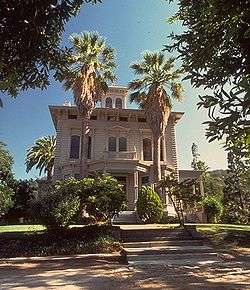 John Muir National Historic Site |
October 15, 1966 (#66000083) |
4202 Alhambra Ave. 37°59′29″N 122°07′49″W |
Martinez | |
| 23 | John Marsh House | 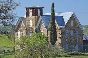 John Marsh House |
October 7, 1971 (#71000136) |
Marsh Creek State Historic Park 37°53′31″N 121°43′23″W |
Brentwood | John Marsh House |
| 24 | Martinez City Library | .JPG) Martinez City Library |
January 31, 2008 (#07001467) |
740 Court St. 38°01′04″N 122°08′03″W |
Martinez | |
| 25 | Martinez Downtown Post Office | 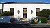 Martinez Downtown Post Office |
May 8, 2012 (#12000265) |
815 Court St. 38°01′04″N 122°08′00″W |
Martinez | part of the US Post Office in California 1900-1941 Thematic Resource |
| 26 | Martinez Grammar School Annex | September 14, 2018 (#100002957) |
525 Henrietta St. 38°00′50″N 122°08′06″W |
Martinez | Now Martinez City Hall. | |
| 27 | Memorial Hall | 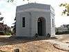 Memorial Hall |
February 25, 2014 (#14000013) |
Pomona St. at Alexander Ave. 38°03′10″N 122°12′35″W |
Crockett | |
| 28 | Charles W. Merrill House | April 7, 2005 (#05000251) |
407 Camino Sobrante 37°53′51″N 122°11′17″W |
Orinda | ||
| 29 | Moraga Adobe | .jpg) Moraga Adobe |
March 16, 1972 (#72000223) |
24 Adobe Lane 37°50′36″N 122°09′09″W |
Orinda | |
| 30 | New Hotel Carquinez | .JPG) New Hotel Carquinez |
May 7, 1992 (#92000466) |
410 Harbour Way 37°56′14″N 122°21′34″W |
Richmond | |
| 31 | Nystrom Elementary School-The Maritime Building | October 2, 2017 (#100001662) |
230 Harbor Way S. 37°55′41″N 122°21′36″W |
Richmond | ||
| 32 | Old Borges Ranch | .JPG) Old Borges Ranch |
July 7, 1981 (#81000147) |
1035 Castlerock Rd. 37°53′24″N 122°00′09″W |
Walnut Creek | |
| 33 | Don Fernando Pacheco Adobe | .JPG) Don Fernando Pacheco Adobe |
June 6, 1980 (#80000798) |
3119 Grant St. 37°59′46″N 122°02′33″W |
Concord | |
| 34 | Point Richmond Historic District | .jpg) Point Richmond Historic District |
November 5, 1979 (#79000472) |
Off CA 17 37°55′34″N 122°23′07″W |
Richmond | |
| 35 | Port Chicago Naval Magazine National Memorial | 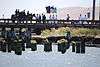 Port Chicago Naval Magazine National Memorial |
October 28, 2009 (#11000237) |
4202 Alhambra Ave. 38°03′27″N 122°01′47″W |
Martinez | |
| 36 | Port Costa School | Port Costa School |
May 25, 1988 (#88000563) |
Plaza El Hambre 38°02′41″N 122°11′19″W |
Port Costa | |
| 37 | Richmond Shipyard Number Three | .jpg) Richmond Shipyard Number Three |
April 28, 2000 (#00000364) |
Point Potrero 37°54′27″N 122°21′59″W |
Richmond | |
| 38 | Riverview Union High School Building | Riverview Union High School Building |
October 14, 1998 (#98001243) |
1500 W. 4th St. 38°00′59″N 121°49′36″W |
Antioch | |
| 39 | Patrick Rodgers Farm | .JPG) Patrick Rodgers Farm |
March 22, 1991 (#91000305) |
315 Cortsen Rd. 37°56′35″N 122°05′13″W |
Pleasant Hill | |
| 40 | Rosie the Riveter-World War II Home Front National Historical Park | 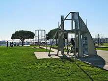 Rosie the Riveter-World War II Home Front National Historical Park |
January 31, 2001 (#01000287) |
Shipyards of Richmond 37°54′53″N 122°20′48″W |
Richmond | |
| 41 | Shadelands Ranch House | .JPG) Shadelands Ranch House |
August 29, 1985 (#85001915) |
2660 Ygnacio Valley Rd. 37°55′33″N 122°01′13″W |
Walnut Creek | |
| 42 | Shannon-Williamson Ranch | .JPG) Shannon-Williamson Ranch |
January 29, 1987 (#87000003) |
RR 1/Lone Tree Way 37°57′41″N 121°45′45″W |
Antioch | Geocode coords are the current location of the ranch house. |
| 43 | SS Red Oak Victory (victory ship) | _2.JPG) SS Red Oak Victory (victory ship) |
January 30, 2001 (#00001674) |
1500 Dornan Dr, Terminal One, Port of Richmond 37°54′17″N 122°21′52″W |
Richmond | |
| 44 | Tao House | Tao House |
May 6, 1971 (#71000137) |
1.5 miles (2.4 km) west of Danville 37°49′28″N 122°01′47″W |
Danville | Residence of Eugene O'Neill |
| 45 | Tassajara One Room School | 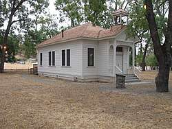 Tassajara One Room School |
April 11, 2014 (#14000135) |
1650 Finley Rd. 37°48′12″N 121°51′36″W |
Danville | |
| 46 | Tucker House | .JPG) Tucker House |
December 17, 1999 (#99001563) |
110 Escobar St. 38°00′55″N 122°08′28″W |
Martinez | |
| 47 | Winehaven | .JPG) Winehaven |
October 2, 1978 (#78000658) |
Point Molate 37°57′05″N 122°25′03″W |
Richmond |
See also
| Wikimedia Commons has media related to National Register of Historic Places in Contra Costa County, California. |
- List of National Historic Landmarks in California
- National Register of Historic Places listings in California
- California Historical Landmarks in Contra Costa County, California
References
- The latitude and longitude information provided in this table was derived originally from the National Register Information System, which has been found to be fairly accurate for about 99% of listings. Some locations in this table may have been corrected to current GPS standards.
- "National Register of Historic Places: Weekly List Actions". National Park Service, United States Department of the Interior. Retrieved on June 19, 2020.
- Numbers represent an ordering by significant words. Various colorings, defined here, differentiate National Historic Landmarks and historic districts from other NRHP buildings, structures, sites or objects.
- "National Register Information System". National Register of Historic Places. National Park Service. July 9, 2010.
- The eight-digit number below each date is the number assigned to each location in the National Register Information System database, which can be viewed by clicking the number.
| Topics | |
|---|---|
| Lists by state |
|
| Lists by insular areas | |
| Lists by associated state | |
| Other areas | |
| Related | |
| |
This article is issued from Wikipedia. The text is licensed under Creative Commons - Attribution - Sharealike. Additional terms may apply for the media files.