Najafgarh
Najafgarh is a town in the South West Delhi district in the National Capital Territory of Delhi, India. It is one of the three subdivisions of the Southwest Delhi district.[2] Najafgarh is located at the outskirts of the southwestern part of Delhi near the Haryana border, a distance of 29 kilometres (18 miles) from the New Delhi City Center. It has a mixture of rural and urban populations from Delhi and Haryana. Due to the presence of much freehold land, Najafgarh is one of the fastest-developing tehsils (sub-districts) in southwestern Delhi.
Najafgarh | |
|---|---|
Subdistrict and Sub – City | |
| Nickname(s): The Royal Land | |
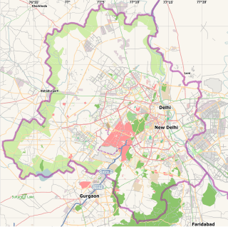 Najafgarh Location in India | |
| Coordinates: 28°36′45″N 76°59′5″E | |
| Country | |
| State | Delhi |
| District | South West Delhi |
| Government | |
| • Body | Municipal Corporation of Delhi |
| Population (2011) | |
| • Total | 1,365,152[1] |
| Languages | |
| • Spoken | Haryanvi, English Hindi |
| Time zone | UTC+5:30 (IST) |
| Lok Sabha constituency | West Delhi |
| Vidhan Sabha constituency | Najafgarh |
| Civic agency | Municipal Corporation of Delhi |
Najafgarh is primarily known for being an economic and transport hub in rural Delhi. Major markets located in Najafgarh include Main Market, Nawada Bazaar (som bazaar), Anaz Mandi (foodgrain market), Tura Mandi (fodder market) and Sabzi Mandi (vegetable market). Seven roads start at the Najafgarh Phirni (circular road) and go to: Inderlok, Chhawla, Khaira, Ghuman Hera, Galib Pur, Dauralla, Dhansa, Jharoda, Dichaon and Nangloi. The roads towards Chhawla, Dhansa and Jharoda further lead up to the cities of Gurgaon, Jhajjar and Bahadurgarh in Haryana.
History
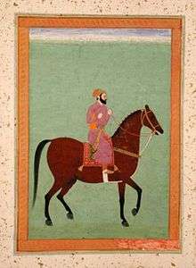
Najafgarh was named after Mirza Najaf Khan[3][4] (1723–1782) the commander-in-chief of the Mughal Army under King Shah Alam II.[5][6] He marched several kilometers from the capital of Shahjahanabad to establish a military outpost, which would guard Delhi against attacks by British, Rohillas and Sikhs. He built a strong fort,[7] in the suburbs beyond the capital city, and settled a small number of the Mughal here. That fort was later named Najafgarh.[8] After the death of Najaf Khan, Najafgarh later became a fortified stronghold of the Rohilla Afghan chieftain Zabita Khan (b. 1785).[9]
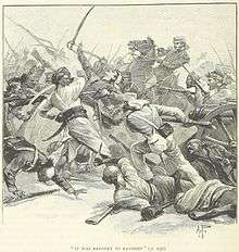
During the Indian Rebellion of 1857, and as a part of the Siege of Delhi,[10] the Battle of Najafgarh took place on 25 August 1857[11] between Indian rebels and British Raj soldiers.[12] Approximately 800 people were killed.[13] After the defeat of the Mughal troops in 1857, Delhi came under the control of the British Empire in 1858. Najafgarh became a part of Delhi district[14] of the Delhi Division of Punjab Province. Delhi was transferred from the North-Western Provinces (later the United Provinces) to Punjab by the British Government in 1859.[15]
In 1861, the North-Western Provinces education system was abolished in Delhi,[16]:18 and a new system for schools modelled on the Punjab education system was introduced by W.M. Holroyd, the Inspector of Schools for the Ambala Division.[16]:47 New schools were opened at Narela, Najafgarh, Mehrauli and their suburbs. Several schools were opened in the following decades. The Delhi Normal School was shifted to Najafgarh from Kashmere Gate in 1911.[16]:71[17] The Delhi Normal School, with a small attached Model School,[18] trained its teachers in closer accordance with European methods than any other Normal School in Northern India.[19]
In 1947, Najafgarh became a part of independent India and fell under the union territory of Delhi. Najafgarh Assembly Constituency was established in 1993 when the Delhi legislative assembly was re-established after the Constitution (Sixty-ninth Amendment Act, 1991) came into force. This declared the Union Territory of Delhi to be formally known as National Capital Territory of Delhi.[20] Najafgarh is now one of the most populous electoral regions in the National Capital Region of India (NCR). Najafgarh is surrounded by 70 villages bordering Haryana. The borders are 10 kilometres (6.2 mi) to 15 kilometres (9.3 mi) from the main Najafgarh Market.
Geography

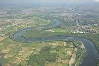
Najafgarh is located at 28.60°N 76.98°E[21] in the South West Delhi district in the NCT of Delhi. Najafgarh is situated 29 kilometres (18 mi) Southwest of the New Delhi City Centre and 10 kilometres (6.2 mi) northwest to the district headquarters at Dwarka. It has an average elevation of 218 m (715 ft) above mean Sea Level.[22] Najafgarh Drain, the continuation of the Sahibi River and an elongation of the Najafgarh Lake is the Indian capital's most polluted body of water[23] due to the direct inflow of untreated sewage from surrounding populated areas. A January 2005 report by the Central Pollution Control Board classifies this drain, with 13 other highly polluted wetlands, under category ‘‘D’’ for assessing the water quality of wetlands in wildlife habitats.[24][25][26]
Najafgarh is surrounded by a number of important villages of the South West Delhi district. Like all the administrative subdivisions of the Southwest District of Delhi, Najafgarh is composed of a group of villages. Some of the villages around Najafgarh are: Kair, Roshan pura baprola, Asalatpur Khadar, Haibat Pur, Pandwala Kalan, Badu Sarai, Kangan Heri, Dauralla, Dindarpur, Ghuman Hera, Khaira, Delhi, Bakkargarh, Jaffarpur Kalan, Rawta, Surheda, Khera Dabar, Daulatpur, Dhansa, Galibpur, Jhuljhuli, Jhatikra, Kazipur, Kharkhari Nahar, Sidipur, KharKhari Jatmal, KharKhari Round, Hasanpur, Delhi, Mundhela Khurd, Mundhela Kalan, Nanak Heri, Nangli Sakrawati, Paprawat, Pandwalan Khurd, Pandwalan Kalan, Rewla Khanpur, Chhawla, Goela Khurd, Tajpur Khurd, Sarang Pur, Sherpur, Shikar Pur, Samaspur Khalsa, Ujwa, Daryapur Khurd, Issapur and Malikpur. Najafgarh is surrounded by a number of important towns of Delhi like Surkhpur and Mitraon to the west and Dichaon Kalan to the north.
Demographics
As of 2011 India census, the population of Najafgarh is 1,365,152.[1] Female sex Ratio is of 872 against Delhi's average of 868. Moreover, the Child Sex Ratio in Najafgarh is around 832 compared to Delhi's average of 871.[1] The majority of the inhabitants are locals others are from Haryana, Uttrakhand, Punjab, Himachal Pradesh, Bihar and Uttar Pradesh. The literacy rate is 88.1%.[1] Schedule Caste (SC) constitutes 12.60% of total population in Najafgarh.
Politics
Pravesh Verma of BJP is the MP from this constituency while Kailash Gahlot, Advocate of the Aam Aadmi Party is MLA and Parliamentary Secretary, Government of NCT of Delhi from this region. Mr. Gahlot defeated former MLA Bharat Singh of the INLD in the 2015 Delhi Legislative Assembly election
Economy

Najafgarh Market is famous for the different varieties of shops including textiles, hardware, ornament, sports, and sweets. Jawahar Chowk is the oldest place in the market.
Najafgarh is also in close proximity to Gurgaon, which is a hub for numerous companies, both Indian and multinational. There are several Ayurvedic and advanced treatment centres and medical centres and charitable clinics. They are located in and around Najafgarh. Sai Baba of Shirdi, and the Suredha Temple., There are meditation centres in and around Najafgarh including Radha Soami Satsang Beas at Ranaji Enclave and Dindarpur, Osho Dham (of Guru Rajneesh), Ashram of Sudhanshu Ji Maharaj at Bakkarwala, Nirmal Dham of Nirmala Devi and Baba Haridas temple in Jharodha Kalan In some of the centres there are free medical facilities or discounted/subsidized medical facilities.
The Special Forces Academy and the Special Operations Centres are in Najafgarh. The Delhi Police, Border Security Force, Central Reserve Police Force(CRPF) Camp (part of the Indian Government's Para Military Forces) Bani Camp and the Delhi Police Training Centre are also located in the vicinity of Najafgarh. The Delhi Police Training Centre in Jharodha is the first major training centre for the recruitment of Delhi Police Constables, Sub-Inspectors and other ranks. A variety of training is provided at this centre such as bomb disposal, riot protection, law and order management, etc. The centre is in two parts – one is the Delhi Police Training School and the other is the Delhi Police Training College. DANIPS and IPS officers of AGMUT cadres are provided induction training in the Najafgarh Police Training Centre.
Transport
Indira Gandhi International Airport is the nearest international Airport to Najafgarh. It is the primary airport serving the whole NCR Region. The Metro network extended from Dwarka to Najafgarh as part of Phase 3 of Delhi Metro connecting it with the satellite city of Noida. The official deadline for this project was December 2016 and the project was completed in September 2019. The metro connects the Dwarka station and the Old PHC (Public Health Centre) of Najafgarh. However, it is unlikely to connect the Rural Belt which has led to a demand for new Metro to Dhansa.
Najafgarh is well connected by drivable roads with major destinations all over Delhi and Haryana. The Main Najafgarh Road (officially Shivaji Road) connects Najafgarh to the city proper of New Delhi while a number of other roads connect it to several villages along the Delhi-Haryana Border. The DTC (Delhi Transport Corporation) and DIMTS (Delhi Multi-Model Transit System) provide bus services from Najafgarh Bus Terminal to the other parts of Delhi like Nehru Place, Inderlok, Tilak Nagar, Safdarjung and Azadpur while Haryana Roadways runs Buses connecting Najafgarh with Gurgaon, Bahadurgarh and Jhajjar. Auto rickshaws and private Buses are preferred as well by a large number of people.
Notable Persons
There are many notable persons from Najafgarh:
- Ch. Brahm Prakash Yadav: first chief minister of Delhi.[27]
- Virender Sehwag: Indian Cricketer, born in Najafgarh[28][29][30]
- Sushil Kumar: Indian wrestler, born in Baprola Village, Najafgarh[31][32]
See also
- Mirza Najaf Khan
- Najafgarh drain, Delhi
- Najafgarh drain bird sanctuary, Delhi
- Najafgarh lake or Najafgarh jheel (now completely drained by Najafgarh drain)
References
- "Census of India 2011 Primary Census Abstract" (PDF). Government of India. Archived (PDF) from the original on 14 November 2013.
- "South West District". www.delhi.gov.in. Archived from the original on 15 September 2016. Retrieved 23 September 2016.
- Chenoy, Shama Mitra (1998). Shahjahanabad: A City of Delhi, 1638–1857. Munshiram Manoharlal Publishers. p. 109. ISBN 9788121508025.
- Delhi Govt Website Archived 2010-09-19 at the Wayback Machine
- Qanung, K R; Singh, Vir. History of the Jats (Upto The Death Of Mirza Najaf Khan, 1782).
- Gupta, Hari Ram (1944). A History of the Sikhs, from Nadir Shah's Invasion to the Rise of Ranjit Singh, 1739–1799: Cis-Sutlej Sikhs, 1769–1799. Punjab: Minerva Book Shop. Retrieved 23 September 2016.
- Burton-Page, John (2008). Indian Islamic Architecture: Forms and Typologies, Sites and Monuments. BRILL. ISBN 9004163395.
- Spear, Thomas George Percival; Gupta, Narayani; Sykes, Laura (1994). Delhi, its monuments and history. Oxford University Press. ISBN 9780195634600.
- Strategy Framework for Delhi beyond the Commonwealth Games 2010, BY DANNY CHERIAN, 2004 Archived 29 October 2013 at the Wayback Machine
- Edwardes, Michael (1963). Battles of the Indian Mutiny. London: Pan Books. ISBN 0-330-02524-4.
- Haigh, R. H.; Turner, Philip Wilson. John Nicholson, the Battle of Najafgarh and the Siege of Delhi. Sheffield City Polytechnic, Department of Political Studies.
- Dalrymple, William (2006). The last Mughal : the fall of a dynasty, Delhi, 1857. New Delhi: Penguin, Viking. ISBN 0-670-99925-3.
- Indian Mutiny 1857 – 58 – Vol. I. Asian Educational Services. ISBN 9788120619937.
- ""Chapter 1: Introduction": Economic Survey of Delhi, 2005–2006" (PDF). Planning Department, Government of National Capital Territory of Delhi. Archived from the original (PDF) on 13 November 2016. Retrieved 1 October 2016.
- Gupta, Narayani (1981). Delhi Between Two Empires, 1803–1931. Oxford University Press.
- Sharma, Ajay Kumar (2011). A History of Educational Institutions in Delhi. New Delhi: Sanbun Publishers. ISBN 9789380213149.
- The Platinum Heritage- 1920–1955. New Delhi: Modern School Booklet. 1955.
- 'Final Memorandum by major W.R.M. Holroyd Regarding the Central Training College,' incld. in, Leitner to offg. sec. to the Government of the Punjab, 1 June 1878, no. 354, OIOC P/1148
- Allender, Tim (2006). Ruling Through Education: The Politics of Schooling in the Colonial Punjab. Sterling Publishers Pvt. Ltd. pp. 239, 240. ISBN 9781932705706.
- "THE CONSTITUTION (Sixty-ninth Amendment) Act, 1991". Archived from the original on 21 August 2016.
- "Najafgarh, New Delhi, Delhi, India Map Lat Long Coordinates". www.latlong.net. Archived from the original on 23 September 2016. Retrieved 23 September 2016.
- "Elevation of Najafgarh, New Delhi, Delhi, 110043 with altitude and height". Archived from the original on 23 September 2016. Retrieved 23 September 2016.
- "Najafgarh basin is Delhi's most polluted area". www.indianexpress.com. Archived from the original on 19 January 2010. Retrieved 23 September 2016.
- "Blot across the Capital: Najafgarh most polluted". cities.expressindia.com. Retrieved 23 September 2016.
- "Environment minister raises a stink over Najafgarh jheel". cities.expressindia.com. Retrieved 23 September 2016.
- "Najafgarh drain 11th among highly polluted industrial clusters". The Times of India. Retrieved 23 September 2016.
- Puri, Yogesh (1993). Party Politics in the Nehru Era: A Study of Congress in Delhi. National Book Organisation. p. 147. ISBN 9788185135724.
- Garg, Chitra (2010). Indian Champions: Profiles of Famous Indian Sportspersons. Rajpal & Sons. p. 191. ISBN 9788170288527. Retrieved 23 September 2016.
- Sen, Ronojoy (27 October 2015). Nation at Play: A History of Sport in India. Columbia University Press. p. 276. ISBN 9780231539937.
- Dwivedi, Sandeep (11 January 2014). "The unlikely makeover of Virender Sehwag". The Indian Express. Archived from the original on 2 December 2016. Retrieved 23 September 2016.
- "Man from Baprola achieved what 'Pocket Dynamo' did 56 years ago – The Times of India". The Times Of India. Archived from the original on 12 January 2017. Retrieved 23 September 2016.
- "Sushil's journey: From mud pits to Olympic podiums". The Hindu. The Hindu. 12 August 2012. Archived from the original on 17 February 2016. Retrieved 23 September 2016.