Mueang Yala District
Mueang Yala (Thai: เมืองยะลา, pronounced [mɯ̄a̯ŋ já(ʔ).lāː]; Pattani Malay: ยาลอ, pronounced [jāː.lɔː]) is the capital district (amphoe mueang) of Yala Province, southern Thailand.
Mueang Yala เมืองยะลา | |
|---|---|
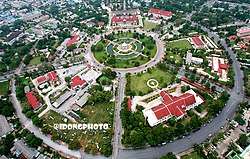 Aerial view of Mueang Yala District, which was praised as the most beautiful city planning in the country | |
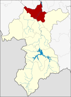 District location in Yala Province | |
| Coordinates: 6°32′33″N 101°16′59″E | |
| Country | Thailand |
| Province | Yala |
| Seat | Sateng |
| Subdistrictss | 14 |
| Mubans | 80 |
| Area | |
| • Total | 258.0 km2 (99.6 sq mi) |
| Population (2014) | |
| • Total | 165,005 |
| • Density | 620.3/km2 (1,607/sq mi) |
| Time zone | UTC+7 (ICT) |
| Postal code | 95000 |
| Geocode | 9501 |
Geography
Neighboring districts are (from the north clockwise): Khok Pho, Mae Lan and Yarang of Pattani Province; Raman, Krong Pinang and Yaha of Yala province; and Saba Yoi of Songkhla Province.
The main river is the Pattani River, which runs through the town of Yala.
History
Originally only known as Mueang district, the district was renamed Sateng in 1917 to share the name with the central sub-district.[1] In 1938, the district was renamed Mueang Yala to conform with the common name of the central districts of a province.[2]
Five sub-districts are scheduled to be split off to form the new district Lam Mai in 2015.[3]
Administration
Central administration
Mueang Yala is divided into 14 sub-districts (tambons), which are further subdivided into 80 administrative villages (mubans).
| No. | Name | Thai | Villages | Pop.[4] |
|---|---|---|---|---|
| 1. | Sateng | สะเตง | - | 61,250 |
| 2. | Budi | บุดี | 8 | 10,700 |
| 3. | Yupo | ยุโป | 6 | 6,829 |
| 4. | Lidon | ลิดล | 5 | 5,876 |
| 6. | Yala | ยะลา | 3 | 3,479 |
| 8. | Tha Sap | ท่าสาป | 6 | 7,507 |
| 9. | Lam Mai | ลำใหม่ | 7 | 7,015 |
| 10. | Na Tham | หน้าถ้ำ | 4 | 3,241 |
| 11. | Lam Phaya | ลำพะยา | 7 | 5,042 |
| 12. | Po Seng | เปาะเส้ง | 4 | 5,284 |
| 14. | Phron | พร่อน | 6 | 5,263 |
| 15. | Bannang Sareng | บันนังสาเรง | 6 | 7,414 |
| 16. | Sateng Nok | สะเตงนอก | 13 | 30,395 |
| 18. | Ta Se | ตาเซะ | 5 | 5,710 |
Missing numbers are tambons which now form Krong Pinang District.
Local administration
There is one city (thesaban nakhon) in the district:
- Yala (Thai: เทศบาลนครยะลา) consisting of sub-district Sateng.
There is one town (thesaban mueang) in the district:
- Sateng Nok (Thai: เทศบาลเมืองสะเตงนอก) consisting of sub-district Sateng Nok.
There are four sub-district municipalities (thesaban tambons) in the district:
- Lam Mai (Thai: เทศบาลตำบลลำใหม่) consisting of parts of sub-district Lam Mai.
- Budi (Thai: เทศบาลตำบลบุดี) consisting of sub-district Budi.
- Yupo (Thai: เทศบาลตำบลยุโป) consisting of sub-district Yupo.
- Tha Sap (Thai: เทศบาลตำบลท่าสาป) consisting of sub-district Tha Sap.
There are nine sub-district administrative organizations (SAO) in the district:
- Lidon (Thai: องค์การบริหารส่วนตำบลลิดล) consisting of sub-district Lidon.
- Yala (Thai: องค์การบริหารส่วนตำบลยะลา) consisting of sub-district Yala.
- Lam Mai (Thai: องค์การบริหารส่วนตำบลลำใหม่) consisting of parts of sub-district Lam Mai.
- Na Tham (Thai: องค์การบริหารส่วนตำบลหน้าถ้ำ) consisting of sub-district Na Tham.
- Lam Phaya (Thai: องค์การบริหารส่วนตำบลลำพะยา) consisting of sub-district Lam Phaya.
- Po Seng (Thai: องค์การบริหารส่วนตำบลเปาะเส้ง) consisting of sub-district Po Seng.
- Phron (Thai: องค์การบริหารส่วนตำบลพร่อน) consisting of sub-district Phron.
- Bannang Sareng (Thai: องค์การบริหารส่วนตำบลบันนังสาเรง) consisting of sub-district Bannang Sareng.
- Ta Se (Thai: องค์การบริหารส่วนตำบลตาเซะ) consisting of sub-district Ta Se.
References
- ประกาศกระทรวงมหาดไทย เรื่อง เปลี่ยนชื่ออำเภอ (PDF). Royal Gazette (in Thai). 34 (0 ก): 40–68. 1917-04-29.
- พระราชกฤษฎีกาเปลี่ยนนามจังหวัด และอำเภอบางแห่ง พุทธศักราช ๒๔๘๑ (PDF). Royal Gazette (in Thai). 55 (0 ก): 658–666. 1938-11-14.
- http://www.law.moi.go.th/pdf/2558_1_19_2m.pdf%5B%5D
- "Population statistics 2014" (in Thai). Department of Provincial Administration. Retrieved 2015-03-11.
| Wikimedia Commons has media related to Mueang Yala District. |