Muak Lek District
Muak Lek (Thai: มวกเหล็ก, pronounced [mûa̯k lèk]) is a district (amphoe) in Saraburi Province, Thailand.
Muak Lek มวกเหล็ก | |
|---|---|
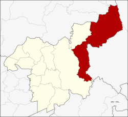 District location in Saraburi Province | |
| Coordinates: 14°39′20″N 101°11′54″E | |
| Country | Thailand |
| Province | Saraburi |
| Seat | Muak Lek |
| Area | |
| • Total | 681.4 km2 (263.1 sq mi) |
| Population (2005) | |
| • Total | 49,572 |
| • Density | 73/km2 (190/sq mi) |
| Time zone | UTC+7 (ICT) |
| Postal code | 18180 |
| Geocode | 1911 |
Geography
Muak Lek, in the east of the province, is the largest of Saraburi's districts. Neighbouring districts are from the north clockwise: Phatthana Nikhom, Tha Luang, and Lam Sonthi of Lopburi Province; Sikhio and Pak Chong of Nakhon Ratchasima Province; Mueang Nakhon Nayok of Nakhon Nayok Province; and Kaeng Khoi and Wang Muang of Saraburi.
The district is in the hills of the Phetchabun Mountains, which separate central Thailand from the northeastern part (Isan). To the south of the district is Khao Yai National Park.
History
The district was created on 27 December 1968, when the area of the former tambon Muak Lek in Kaeng Khoi District was split into three tambons containing 33 villages, and formed a new district named Muak Lek.[1] The new district started operation on 21 January 1969. On 7 May 1970 the permanent district office building was opened.
In 1988 the northwestern area was split off from the district to form the new Wang Muang District.
Traffic
The district is crossed by the Mittraphap Road and the northeastern railway line on their way through the hills.
Administration
The district is divided into six sub-districts (tambons), which are further subdivided into 65 villages (mubans). Muak Lek itself has township status (thesaban tambon) and covers parts of tambons Muak Lek and Mittraphap. There are six tambon administrative organizations (TAO).
| No. | Name | Thai name | Villages | Pop. |
|---|---|---|---|---|
| 1. | Muak Lek | มวกเหล็ก | 13 | 9,925 |
| 2. | Mittraphap | มิตรภาพ | 10 | 10,448 |
| 4. | Nong Yang Suea | หนองย่างเสือ | 14 | 6,318 |
| 5. | Lam Somphung | ลำสมพุง | 10 | 4,468 |
| 7. | Lam Phaya Klang | ลำพญากลาง | 18 | 11,305 |
| 9. | Sap Sanun | ซับสนุ่น | 15 | 7,108 |
The missing numbers 3, 6 and 8 were the tambon which now forms Wang Muang.
Economy
The headquarters of the Thai state enterprise, the Dairy Farming Promotion Organization of Thailand (DPO), is in Mittraphap Sub-district.[2]
References
- พระราชกฤษฎีกาตั้งอำเภอมวกเหล็ก พ.ศ. ๒๕๑๑ (PDF). Royal Gazette (in Thai). 85 (121 ก): 1051–1053. December 31, 1968.
- "Contact us". Dairy Farming Promotion Organization of Thailand (DPO). Retrieved 2018-12-21.
External links
- amphoe.com
- Asia-Pacific International University
- AIMS
- http://www.muaklek.net
- https://web.archive.org/web/20070928225623/http://www.saraburi.go.th/file/am-muak.doc (Thai winword file)
| Wikimedia Commons has media related to Muak Lek District. |