Mount Cook Village
Aoraki / Mount Cook, often referred to as Mount Cook Village, is located within New Zealand's Aoraki / Mount Cook National Park at the end of State Highway 80, only 15 kilometres (9.3 mi)[1] south of the summit of the country's highest mountain, also called Aoraki / Mount Cook, in the Southern Alps.
Aoraki / Mount Cook Mount Cook Village | |
|---|---|
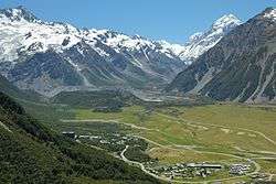 Mount Cook Village down below in Hooker Valley, The Hermitage on the left, lodge & motel complex on the bottom right | |
Aoraki / Mount Cook | |
| Coordinates: 43°44′0″S 170°5′44″E | |
| Country | New Zealand |
| Island | South Island |
| Region | Aoraki / Mount Cook National Park |
| Government | |
| • Territorial Authority | Mackenzie District Council |
| • Regional council | Environment Canterbury |
| Elevation | 750 m (2,460 ft) |
| Population | |
| • Total | 250 |
Being situated inside a National Park, it is not possible to own property in Mount Cook Village, however, because of the year-round operation of the hotel and motels, the village has a small permanent population of around 250.[2] All buildings and facilities operate on concessions and leases from the government. The village has no grocery stores apart from a small in-hotel convenience store. The nearest supermarket is 65 kilometres (40 mi) away in Twizel, the closest town. There is a self-service petrol pump behind the hotel complex, however the fuel price reflects the remote location.
Mount Cook Village operates a small school with a roll as low as a dozen children, the only school in New Zealand inside a national park.[3]
Tourism
Mount Cook Village caters to a steady flow of around 250,000 visitors per year[2] with a wide range of facilities and accommodation.
An international style hotel, The Hermitage[4] the name of which dates back to the original hotel built in 1884, is the only prominent larger building in the village and a popular location, especially for international tourists. The Hermitage is sometimes used as an alternative name for the settlement. The hotel also owns and operates chalets and a lodge & motel with options ranging from backpacker accommodation through to family units.
There are two more motels in the village, and a total of four restaurants or pubs, two of which are inside the main hotel complex. The buildings and motel units are connected via paved footpaths. The small White Horse Hill camping ground is located about 2 kilometres (1.2 mi) outside the village, connected via a walking track.
Commercial operations run guided walks, 4WD safaris, boating on the Tasman glacier lake, horse treks, fishing, and scenic flights including landing on the glaciers. These are based at the hotel, departing and returning to the hotel's main entrance.
A number of nearby walks and climbs ranging from 10 minute bush walks to multi-day tramping tracks and routes can be explored from Mount Cook Village.
There are three short walking tracks through forest areas within the village and on its outskirts, as well as the starting points of longer walking tracks ranging from the popular and easy Hooker Valley Track to more strenuous walks such as the steep track to Sealy Tarns.[5]
The village is home to the park's visitor centre,[6] and the starting point for climbers, hunters[7] and trampers visiting the many huts.[8]
History
The first building at the location of Mount Cook Village was the second Hermitage hotel, built in 1913 and opened in 1914, however that building burned to the ground in 1957 and was replaced in 1958 by what later became the current hotel.
The 1960s and 1970s saw significant extensions to the hotel and Mount Cook Village, including water mains, sewerage treatment, local streets, and the sealing of State Highway 80, which greatly improved access. A local fire brigade was established in 1976.[2]
The official name of the settlement was amended to become a dual name, Aoraki / Mount Cook, by the Ngāi Tahu Claims Settlement Act 1998.[9]
| Wikimedia Commons has media related to Mount Cook Village. |
Climate
| Climate data for Mount Cook Village, 770 m | |||||||||||||
|---|---|---|---|---|---|---|---|---|---|---|---|---|---|
| Month | Jan | Feb | Mar | Apr | May | Jun | Jul | Aug | Sep | Oct | Nov | Dec | Year |
| Average high °C (°F) | 20.3 (68.5) |
20.7 (69.3) |
17.8 (64.0) |
14.3 (57.7) |
10.6 (51.1) |
7.1 (44.8) |
6.3 (43.3) |
8.2 (46.8) |
11.4 (52.5) |
13.9 (57.0) |
16.2 (61.2) |
18.2 (64.8) |
13.8 (56.8) |
| Daily mean °C (°F) | 14.4 (57.9) |
14.5 (58.1) |
12.2 (54.0) |
9.1 (48.4) |
5.9 (42.6) |
2.9 (37.2) |
2.1 (35.8) |
3.6 (38.5) |
6.3 (43.3) |
8.7 (47.7) |
10.7 (51.3) |
12.7 (54.9) |
8.6 (47.5) |
| Average low °C (°F) | 8.6 (47.5) |
8.4 (47.1) |
6.7 (44.1) |
4.0 (39.2) |
1.2 (34.2) |
−1.3 (29.7) |
−2.1 (28.2) |
−0.9 (30.4) |
1.3 (34.3) |
3.5 (38.3) |
5.2 (41.4) |
7.2 (45.0) |
3.5 (38.3) |
| Average rainfall mm (inches) | 354 (13.9) |
216 (8.5) |
383 (15.1) |
294 (11.6) |
320 (12.6) |
246 (9.7) |
238 (9.4) |
261 (10.3) |
304 (12.0) |
357 (14.1) |
328 (12.9) |
355 (14.0) |
3,656 (143.9) |
| Source: Climate-data.org[10] | |||||||||||||
References
- "Aoraki / Mount Cook, Canterbury - NZ Topo Map". NZ Topo Map. Land Information New Zealand. Retrieved 25 August 2016.
- "Aoraki / Mount Cook Village: Long-term Community Plan", Department of Conservation
- Charlie Mitchell (12 August 2016). "Mt Cook: The tiny school in the shadow of the mountain". Stuff. Retrieved 25 August 2016.
- "The Hermitage" official website
- "Aoraki / Mount Cook village walking tracks". Department of Conservation. Retrieved 25 August 2016.
- "Aoraki / Mount Cook National Park visitor centre", Department of Conservation
- "...hunting for tahr and chamois is permitted all year round in Aoraki / Mount Cook National Park..."
- "Huts by region: Aoraki / Mount Cook area", Department of Conservation
- "Ngāi Tahu Claims Settlement Act 1998".
- "Climate-data.org – Climate Data for Cities Worldwide". openstreetmap.org. Retrieved 14 April 2020.