Mount Chalmers, Queensland
Mount Chalmers is a town and locality in the Shire of Livingstone, Queensland, Australia.[2][3]
| Mount Chalmers Queensland | |||||||||||||||
|---|---|---|---|---|---|---|---|---|---|---|---|---|---|---|---|
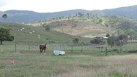 Rural landscape, Mount Chalmers, 2016 | |||||||||||||||
 Mount Chalmers | |||||||||||||||
| Coordinates | 23°17′51″S 150°38′24″E | ||||||||||||||
| Population | 216 (2011 census)[1] | ||||||||||||||
| Postcode(s) | 4702 | ||||||||||||||
| Location |
| ||||||||||||||
| LGA(s) | Shire of Livingstone | ||||||||||||||
| State electorate(s) | Keppel | ||||||||||||||
| Federal Division(s) | Capricornia | ||||||||||||||
| |||||||||||||||
History
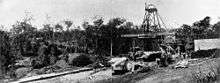
Gold was found in Mount Chalmers in 1860 but gold mining did not commence in the area until 1869. It was named after Mr Chambers who established a battery. In 1899 copper mining commenced.[4]

A provisional school opened on 23 January 1901; it was proclaimed Mount Chalmers State School in 1909.[5]
In 1908 the Yeppoon railway line was established from Sleipners Junction on the North Rockhampton to Emu Park railway line and then through to Yeppoon railway station.[4] Mount Chalmers railway station (23°18′04″S 150°38′28″E) served the town.[6]
In 1911, the census recorded a population of 1181. However, the mining ended in 1914 and people moved away; the 1921 census showed the population had fallen to 95 people.[4]
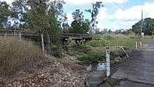
The Yeppoon railway line ceased passenger services in 1978 and closed completely in 2004.[7]
The school was mothballed on 31 December 2005 and its closure finalised on 31 December 2006.[8] In 2014 the Livingstone Shire Council purchased the site for $230,000 for use by the local community.[9] It is located at 18 School Street (23.2989°S 150.6415°E).[10]
In the 2011 census, Mount Chalmers had a population of 216 people.[1]
Amenities
The Mount Chalmers Community History Centre operates from the old school site.[11] The old school also has a library run by volunteers and supported by the Livingstone Shire Council.[12][13]
References
- Australian Bureau of Statistics (31 October 2012). "Mount Chalmers (SSC)". 2011 Census QuickStats. Retrieved 24 July 2016.

- "Mount Chalmers - town (entry 22988)". Queensland Place Names. Queensland Government. Retrieved 24 July 2016.
- "Mount Chalmers - locality (entry 49425)". Queensland Place Names. Queensland Government. Retrieved 24 July 2016.
- "Mount Chalmers". Queensland Places. Centre for the Government of Queensland, University of Queensland. Retrieved 24 July 2016.
- Queensland Family History Society (2010), Queensland schools past and present (Version 1.01 ed.), Queensland Family History Society, ISBN 978-1-921171-26-0
- "Mount Chalmers railway station (entry 22989)". Queensland Place Names. Queensland Government. Retrieved 24 July 2016.
- "Emu Park/Yeppoon Railway" (PDF). Archer Park Rail Museum. Archived from the original (PDF) on 28 February 2016. Retrieved 24 July 2016.
- "Opening and closing dates of Queensland Schools". Queensland Government. Retrieved 24 July 2016.
- "Council purchases Mt Chalmers State School for the community". Livingstone Shire Council. 28 April 2014. Archived from the original on 1 February 2018. Retrieved 1 February 2018.
- Chiclcott, Tanya; Vlasic, Kimberley (7 June 2013). "Full school asssets sale list". The Courier-Mail. Retrieved 30 October 2019.
- "Mt Chalmers Community History Centre". Archived from the original on 1 February 2018. Retrieved 1 February 2018.
- "Mount Chalmers Library". Library Thing. Retrieved 1 February 2018.
- "Libraries". Livingstone Shire Council. Archived from the original on 1 February 2018. Retrieved 1 February 2018.
External links
![]()