Mound Valley, Kansas
Mound Valley is a city in Labette County, Kansas, United States. As of the 2010 census, the city population was 407.[6]
Mound Valley, Kansas | |
|---|---|
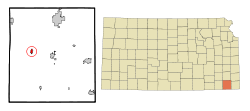 Location within Labette County and Kansas | |
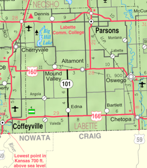 KDOT map of Labette County (legend) | |
| Coordinates: 37°12′22″N 95°24′15″W | |
| Country | United States |
| State | Kansas |
| County | Labette |
| Area | |
| • Total | 0.65 sq mi (1.68 km2) |
| • Land | 0.65 sq mi (1.68 km2) |
| • Water | 0 sq mi (0 km2) |
| Elevation | 833 ft (254 m) |
| Population | |
| • Total | 407 |
| • Estimate (2018)[3] | 375 |
| • Density | 630/sq mi (240/km2) |
| Time zone | UTC-6 (Central (CST)) |
| • Summer (DST) | UTC-5 (CDT) |
| ZIP code | 67354 |
| Area code(s) | 620 |
| FIPS code | 20-48825[4] |
| GNIS feature ID | 0469430[5] |
| Website | www |
History
Mound Valley was founded in 1869. It was named from mound-like hills in the vicinity.[7]
The first post office in Mound Valley was established in May 1870.[8] Mound Valley was incorporated as a city in 1871.[9] The town was a stop on the Missouri-Kansas-Texas railroad line from the 1886 to the 1970s.
Geography
Mound Valley is located at 37°12′22″N 95°24′15″W (37.206173, -95.404231).[10] According to the United States Census Bureau, the city has a total area of 0.65 square miles (1.68 km2), all land.[1]
Climate
The climate in this area is characterized by hot, humid summers and generally mild to cool winters. According to the Köppen Climate Classification system, Mound Valley has a humid subtropical climate, abbreviated "Cfa" on climate maps.[11]
Demographics
| Historical population | |||
|---|---|---|---|
| Census | Pop. | %± | |
| 1880 | 138 | — | |
| 1890 | 545 | 294.9% | |
| 1900 | 533 | −2.2% | |
| 1910 | 956 | 79.4% | |
| 1920 | 803 | −16.0% | |
| 1930 | 666 | −17.1% | |
| 1940 | 648 | −2.7% | |
| 1950 | 566 | −12.7% | |
| 1960 | 481 | −15.0% | |
| 1970 | 467 | −2.9% | |
| 1980 | 381 | −18.4% | |
| 1990 | 405 | 6.3% | |
| 2000 | 418 | 3.2% | |
| 2010 | 407 | −2.6% | |
| Est. 2018 | 375 | [3] | −7.9% |
| U.S. Decennial Census | |||
2010 census
As of the census[2] of 2010, there were 407 people, 170 households, and 105 families residing in the city. The population density was 626.2 inhabitants per square mile (241.8/km2). There were 202 housing units at an average density of 310.8 per square mile (120.0/km2). The racial makeup of the city was 92.9% White, 2.2% Native American, 0.7% from other races, and 4.2% from two or more races. Hispanic or Latino of any race were 2.2% of the population.
There were 170 households of which 28.2% had children under the age of 18 living with them, 43.5% were married couples living together, 13.5% had a female householder with no husband present, 4.7% had a male householder with no wife present, and 38.2% were non-families. 32.4% of all households were made up of individuals and 14.1% had someone living alone who was 65 years of age or older. The average household size was 2.39 and the average family size was 2.99.
The median age in the city was 40.8 years. 25.1% of residents were under the age of 18; 6.4% were between the ages of 18 and 24; 22.9% were from 25 to 44; 28% were from 45 to 64; and 17.7% were 65 years of age or older. The gender makeup of the city was 49.9% male and 50.1% female.
2000 census
As of the census[4] of 2000, there were 418 people, 168 households, and 115 families residing in the city. The population density was 636.5 people per square mile (244.5/km2). There were 190 housing units at an average density of 289.3 per square mile (111.2/km2). The racial makeup of the city was 94.26% White, 2.15% Native American, 1.67% from other races, and 1.91% from two or more races. Hispanic or Latino of any race were 1.91% of the population.
There were 168 households out of which 35.1% had children under the age of 18 living with them, 52.4% were married couples living together, 11.9% had a female householder with no husband present, and 31.5% were non-families. 30.4% of all households were made up of individuals and 16.7% had someone living alone who was 65 years of age or older. The average household size was 2.49 and the average family size was 3.05.
In the city, the population was spread out with 27.5% under the age of 18, 10.5% from 18 to 24, 27.3% from 25 to 44, 21.5% from 45 to 64, and 13.2% who were 65 years of age or older. The median age was 36 years. For every 100 females, there were 85.8 males. For every 100 females age 18 and over, there were 83.6 males.
The median income for a household in the city was $23,542, and the median income for a family was $35,481. Males had a median income of $21,488 versus $13,958 for females. The per capita income for the city was $11,252. About 21.5% of families and 24.1% of the population were below the poverty line, including 29.3% of those under age 18 and 8.2% of those age 65 or over.
Notable people
- George Pepperdine, philanthropist, founder of Pepperdine University and Western Auto
- James Wesley, country music singer
See also
References
- "US Gazetteer files 2010". United States Census Bureau. Archived from the original on 2012-07-02. Retrieved 2012-07-06.
- "U.S. Census website". United States Census Bureau. Retrieved 2012-07-06.
- "Population and Housing Unit Estimates". Retrieved March 27, 2020.
- "U.S. Census website". United States Census Bureau. Retrieved 2008-01-31.
- "US Board on Geographic Names". United States Geological Survey. 2007-10-25. Retrieved 2008-01-31.
- "2010 City Population and Housing Occupancy Status". U.S. Census Bureau. Retrieved March 18, 2012.
- Kansas State Historical Society (1916). Biennial Report of the Board of Directors of the Kansas State Historical Society. Kansas State Printing Plant. pp. 219.
- "Kansas Post Offices, 1828-1961". Kansas Historical Society. Retrieved 12 June 2014.
- Blackmar, Frank Wilson (1912). Kansas: A Cyclopedia of State History, Volume 2. Standard Publishing Company. pp. 330.
- "US Gazetteer files: 2010, 2000, and 1990". United States Census Bureau. 2011-02-12. Retrieved 2011-04-23.
- Climate Summary for Mound Valley, Kansas
Further reading
External links
- City
- Schools
- USD 506, local school district
- Maps
- Mound Valley City Map, KDOT
Municipalities and communities of Labette County, Kansas, United States | ||
|---|---|---|
| Cities | 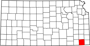 Map of Kansas highlighting Labette County | |
| Unincorporated communities | ||
| Townships |
| |
| Authority control |
|---|