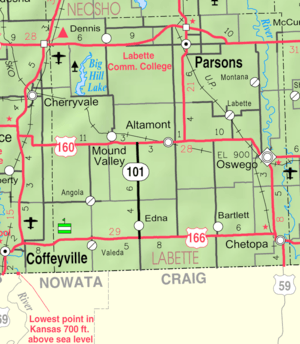
Altamont, Kansas
Altamont is a city in Labette County, Kansas, United States. As of the 2010 census, the city population was 1,080.[6]
Altamont, Kansas | |
|---|---|
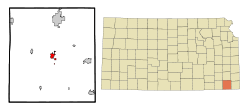 Location within Labette County and Kansas | |
 KDOT map of Labette County (legend) | |
| Coordinates: 37°11′23″N 95°17′37″W | |
| Country | United States |
| State | Kansas |
| County | Labette |
| Founded | 1879 |
| Incorporated | 1884 |
| Named for | Altamont, Illinois |
| Government | |
| • Mayor | Richard Hayward |
| Area | |
| • Total | 1.93 sq mi (4.99 km2) |
| • Land | 1.90 sq mi (4.92 km2) |
| • Water | 0.02 sq mi (0.06 km2) |
| Elevation | 912 ft (278 m) |
| Population | |
| • Total | 1,080 |
| • Estimate (2018)[3] | 1,030 |
| • Density | 560/sq mi (220/km2) |
| Time zone | UTC-6 (CST) |
| • Summer (DST) | UTC-5 (CDT) |
| ZIP code | 67330 |
| Area code | 620 |
| FIPS code | 20-01550[4] |
| GNIS ID | 0469438[5] |
| Website | altamontks.com |
History
Altamont had its start in the year 1879 by the building of the railroad through that territory. The first settlers of Altamont was the Huston family. The present day street is named after them. When they went to the nearby town of Oswego, people would ask them where they lived. They would say about a mile east of the lone tree. Since there weren't many trees in Kansas at the time this would be served as a landmark.[7] It was named after Altamont, Illinois.[8] Altamont was incorporated in 1884.[9]
Geography
Altamont is located at 37°11′23″N 95°17′37″W (37.189803, -95.293529).[10] According to the United States Census Bureau, the city has a total area of 1.66 square miles (4.30 km2), of which 1.64 square miles (4.25 km2) is land and 0.02 square miles (0.05 km2) is water.[11]
Climate
The climate in this area is characterized by hot, humid summers and generally mild to cool winters. According to the Köppen Climate Classification system, Altamont has a humid subtropical climate, abbreviated "Cfa" on climate maps.[12]
Demographics
| Historical population | |||
|---|---|---|---|
| Census | Pop. | %± | |
| 1890 | 454 | — | |
| 1900 | 546 | 20.3% | |
| 1910 | 606 | 11.0% | |
| 1920 | 603 | −0.5% | |
| 1930 | 598 | −0.8% | |
| 1940 | 642 | 7.4% | |
| 1950 | 652 | 1.6% | |
| 1960 | 672 | 3.1% | |
| 1970 | 845 | 25.7% | |
| 1980 | 1,054 | 24.7% | |
| 1990 | 1,048 | −0.6% | |
| 2000 | 1,092 | 4.2% | |
| 2010 | 1,080 | −1.1% | |
| Est. 2018 | 1,030 | [3] | −4.6% |
| U.S. Decennial Census | |||
2010 census
As of the census[2] of 2010, there were 1,080 people, 419 households, and 291 families residing in the city. The population density was 658.5 inhabitants per square mile (254.2/km2). There were 447 housing units at an average density of 272.6 per square mile (105.3/km2). The racial makeup of the city was 92.7% White, 0.6% African American, 1.9% Native American, 0.5% from other races, and 4.3% from two or more races. Hispanic or Latino of any race were 2.5% of the population.
There were 419 households of which 39.1% had children under the age of 18 living with them, 52.5% were married couples living together, 11.9% had a female householder with no husband present, 5.0% had a male householder with no wife present, and 30.5% were non-families. 27.4% of all households were made up of individuals and 14.1% had someone living alone who was 65 years of age or older. The average household size was 2.58 and the average family size was 3.12.
The median age in the city was 36.1 years. 29.3% of residents were under the age of 18; 8.5% were between the ages of 18 and 24; 26.2% were from 25 to 44; 22% were from 45 to 64; and 14.1% were 65 years of age or older. The gender makeup of the city was 46.7% male and 53.3% female.
2000 census
As of the census[4] of 2000, there were 1,092 people, 427 households, and 303 families residing in the city. The population density was 677.1 people per square mile (261.9/km2). There were 458 housing units at an average density of 284.0 per square mile (109.8/km2). The racial makeup of the city was 96.43% White, 1.37% Native American, 0.18% Asian, 0.09% from other races, and 1.92% from two or more races. Hispanic or Latino of any race were 0.55% of the population.
There were 427 households out of which 35.8% had children under the age of 18 living with them, 60.0% were married couples living together, 8.2% had a female householder with no husband present, and 29.0% were non-families. 26.5% of all households were made up of individuals and 14.8% had someone living alone who was 65 years of age or older. The average household size was 2.51 and the average family size was 3.05.
In the city, the population was spread out with 29.0% under the age of 18, 6.3% from 18 to 24, 25.5% from 25 to 44, 20.7% from 45 to 64, and 18.5% who were 65 years of age or older. The median age was 36 years. For every 100 females, there were 87.0 males. For every 100 females age 18 and over, there were 82.8 males.
The median income for a household in the city was $32,431, and the median income for a family was $40,987. Males had a median income of $30,694 versus $22,019 for females. The per capita income for the city was $14,895. About 5.2% of families and 9.5% of the population were below the poverty line, including 8.2% of those under age 18 and 21.2% of those age 65 or over.
Education
Altamont is served by Labette County USD 506 school district.[13] The district school office, Labette County High School, and Altamont Grade School are located in the city of Altamont, and four grade schools are located in other cities in the school district.
The Labette County High School mascot is the Grizzlies, and their colors are red and gold.[14] Previously, Altamont High School was closed when school unification merged into USD 506.
Altamont Grade School, a Pre-K through 8th grade facility, acts as a feeder school to Labette County High School. Altamont Grade School's mascot is the Eagles, and their colors are Navy and Columbia Blue.[15]
References
- "2018 U.S. Gazetteer Files". United States Census Bureau. Retrieved Nov 1, 2019.
- "U.S. Census website". United States Census Bureau. Retrieved 2012-07-06.
- "Population and Housing Unit Estimates". Retrieved June 4, 2019.
- "U.S. Census website". United States Census Bureau. Retrieved 2008-01-31.
- "US Board on Geographic Names". United States Geological Survey. 2007-10-25. Retrieved 2008-01-31.
- "2010 City Population and Housing Occupancy Status". U.S. Census Bureau. Retrieved March 18, 2012.
- Blackmar, Frank Wilson (1912). Kansas: A Cyclopedia of State History, Embracing Events, Institutions, Industries, Counties, Cities, Towns, Prominent Persons, Etc. Standard Publishing Company. pp. 66.
- "Profile for Altamont, Kansas". ePodunk. Retrieved 12 June 2014.
- Case, Nelson (1893). History of Labette County, Kansas: From the First Settlement to the Close of 1892. Crane & Company. pp. 141.
- "US Gazetteer files: 2010, 2000, and 1990". United States Census Bureau. 2011-02-12. Retrieved 2011-04-23.
- "US Gazetteer files 2010". United States Census Bureau. Archived from the original on 2012-01-25. Retrieved 2012-07-06.
- Climate Summary for Altamont, Kansas
- USD 506 District Map; KSDOT.
- "USD 506 Labette County". USD 506. Retrieved 7 January 2017.
- http://www.usd506.org/vnews/display.v/SEC/Altamont%20Grade%20School
Further reading
External links
- City
- Schools
- USD 506, local school district
- Maps
- Altamont City Map, KDOT
Municipalities and communities of Labette County, Kansas, United States | ||
|---|---|---|
| Cities | 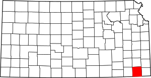 Map of Kansas highlighting Labette County | |
| Unincorporated communities | ||
| Townships |
| |
| Authority control |
|
|---|