Mawlamyine
Mawlamyine (also spelled Mawlamyaing; Mon: မတ်မလီု pronounced [mo̤t məlɜ̤m]; Burmese: မော်လမြိုင်မြို့; MLCTS: mau la. mruing mrui.; pronounced [mɔ̀ləmjàɪ̯ɰ̃ mjo̰]), formerly Moulmein, is the fourth largest city of Myanmar (Burma),[3][4] 300 km south east of Yangon and 70 km south of Thaton, at the mouth of Thanlwin (Salween) River. The city is the capital and largest city of Mon State and the main trading center and seaport in south eastern Myanmar.[5]
Mawlamyine မော်လမြိုင် ဍုၚ်မတ်မလီု | |
|---|---|
City | |
 | |
 Mawlamyine Location of Mawlamyine, Myanmar (Burma) | |
| Coordinates: 16°29′N 97°37′E | |
| Country | |
| State | |
| District | Mawlamyine District |
| Township | Mawlamyine Township |
| Population (2014 Census)[1] | |
| • City | 289,388 |
| • Urban | 253,734 |
| • Rural | 35,654 |
| • Ethnicities | Mons, Burmans, Chinese, Indians, Karens |
| • Religions | Theravada Buddhism, Christianity, Islam, Hinduism |
| Demonym(s) | Mawlamanian |
| Time zone | UTC+6.30 (MST) |
| Area code(s) | 57 |
| [2] | |
Etymology and legend
The Mon name which was previously used for Mawlamyine, Moulmein (မတ်မလီု; [mòt məlɜ̀m]) means "damaged eye" or "one-eyed man."[6][7][8] According to legend, a Mon king had a powerful third eye in the centre of his forehead, able to see what was happening in neighbouring kingdoms. The daughter of one of the neighbouring kings was given in marriage to the three-eyed king and managed to destroy the third eye.[9] The Burmese name "Mawlamyine" is believed to be a corruption of the Mon name.
Moulmein was also spelled as Maulmain or Moulmain or Maulmein in some records of the 19th century. The people of Moulmein were referred as Moulmeinian.[10]
History

Early history
Early Mon reigns
According to Kalyani Inscriptions erected by King Dhammazedi of Hanthawaddy Pegu in 1479, Mawlamyine was mentioned among the ‘32 myo’ or thirty-two Mon cities within the Martaban division.[11] Binnya U, a deputy of Viceroy Saw Binnya was one of the notable governors of Mawlamyine in the early history of the city.
Toungoo dynasty
In May 1541, King Tabinshwehti and his deputy Bayinnaung captured Mawlamyine.[12] During the reign of Bayinnaung, Toungoo Empire became the largest empire in the history of Southeast Asia. After his passing in 1581, his son Nanda Bayin and successors faced with rebellion by Lan Na, Siam, Lan Xang and renewed Portuguese incursions. In 1594, the governor of Mawlamyine who being in league with Siamese King Naresuan revolted against Toungoo court.[13] Since then, the city became under the control of Siam (present-day Thailand) until 1614.
Konbaung dynasty
In 1760, General Minkhaung Nawrahta of the Royal Burmese Army repaired Mawlamyine on his way back from Burmese–Siamese War in Ayutthaya (former capital of Thailand). Kyaikthanlan Pagoda Inscription hinted that in 1764 (1125 ME), General Maha Nawrahta repaired Kyaikthanlan Pagoda on his way to capture Tavoy, and before finishing the repairment, Mawlamyine faced utter destruction.
Colonial Moulmein (1824– 1948)
Mawlamyine was the first capital of British Burma between 1826 and 1852 after the Tanintharyi (Tenassarim) coast, along with Arakan, was ceded to Britain under the Treaty of Yandabo at the end of the First Anglo-Burmese War.[14] After the first Anglo-Burmese war, the British made it their capital between 1826 and 1852, building government offices, churches and a massive prison. They started business enterprises and the country's first newspaper, The Maulmain Chronicle.[15] Between 1826 and 1862, colonial Mawlamyine was the center of British Burma and the first port city that became a strategically important area and a geographical nodal point for the newly occupied British territory in Southeast Asia.[16] Ever since the first British occupation in 1824, the growth and prosperity of Mawlamyine had steadily increased due to timber trade. Nevertheless, the decline in prosperity of Mawlamyine began when the supply of marketable timber from Salween Valley started to decrease in the 1890s.[17]
During British colonial times, Germany, Siam, Persia, Denmark, Norway and Sweden opened and maintained consulate offices in Mawlamyine led by either consuls or vice-consuls while Italy and the United States placed consular agencies in Mawlamyine.[18][19][20] German explorer Johann Wilhelm Helfer's landing at Moulmein shore on 8 February 1837 made him as the first German to arrive Burma in the history.[21][22]
Mawlamyine was the setting of George Orwell's famous 1936 memoir Shooting an Elephant. The essay opens with the striking words:
- "In Moulmein, in Lower Burma, I was hated by large numbers of people—the only time in my life that I have been important enough for this to happen to me."
During colonial times, Moulmein had a substantial Anglo-Burmese population. An area of the city was known as "Little England" due to the large Anglo-Burmese community, many of them running rubber plantations. This has since dwindled to a handful of families as most have left for the UK or Australia.
It was probably best known to English speakers through the opening lines of Rudyard Kipling's poem Mandalay:
- "By the old Moulmein pagoda, lookin' lazy at the sea
- There's a Burma girl a-settin', and I know she thinks o' me".
"The old Moulmein pagoda" - Kyaik Than Lan
The "old Moulmein pagoda" Kipling cites is thought to be the Kyaik Than Lan (also spelled Kyaikthanlan) pagoda in Mawlamyine.[23] It stands on a ridge, giving a panoramic view of the city, and is surrounded by 34 smaller temples.[23] Among its sacred treasures is a hair relic of Buddha,[23][24] received from a hermit in Thaton,[25] as well as a tooth relic conveyed from Sri Lanka by a delegation of monks in ancient times.[25]
Contemporary Mawlamyine
Soon after Burma's independence in 1948, the city fell into the hands of Karen insurgents. The Myanmar military retook the city with the help of UBS Mayu in 1950.[26] Later, many colonial names of streets and parks of the city were changed to more nationalistic Burmese names. Mawlamyine stood as the third-largest city of Myanmar until the recent rise of Naypyidaw.
Geography
Mawlamyine is in the Salween River delta, where the mouth of the Salween is sheltered by Bilugyun Island as it enters the Gulf of Martaban and the Andaman Sea. It is flanked by low hills dotted with ancient pagodas to the east and west.[14]
Climate
| Climate data for Mawlamyine (1981–2010, extremes 1958–1994) | |||||||||||||
|---|---|---|---|---|---|---|---|---|---|---|---|---|---|
| Month | Jan | Feb | Mar | Apr | May | Jun | Jul | Aug | Sep | Oct | Nov | Dec | Year |
| Record high °C (°F) | 37.2 (99.0) |
37.2 (99.0) |
39.4 (102.9) |
38.3 (100.9) |
38.9 (102.0) |
36.1 (97.0) |
33.9 (93.0) |
36.7 (98.1) |
35.0 (95.0) |
37.2 (99.0) |
37.2 (99.0) |
36.1 (97.0) |
39.4 (102.9) |
| Average high °C (°F) | 32.9 (91.2) |
34.4 (93.9) |
35.6 (96.1) |
35.8 (96.4) |
32.5 (90.5) |
29.5 (85.1) |
28.8 (83.8) |
28.6 (83.5) |
30.1 (86.2) |
32.4 (90.3) |
32.8 (91.0) |
32.1 (89.8) |
32.1 (89.8) |
| Average low °C (°F) | 18.4 (65.1) |
19.9 (67.8) |
22.2 (72.0) |
24.7 (76.5) |
24.3 (75.7) |
23.8 (74.8) |
23.6 (74.5) |
23.5 (74.3) |
23.6 (74.5) |
23.6 (74.5) |
22.0 (71.6) |
19.1 (66.4) |
22.4 (72.3) |
| Record low °C (°F) | 12.8 (55.0) |
12.2 (54.0) |
16.7 (62.1) |
19.4 (66.9) |
16.7 (62.1) |
21.1 (70.0) |
18.9 (66.0) |
18.9 (66.0) |
21.1 (70.0) |
19.4 (66.9) |
15.0 (59.0) |
11.1 (52.0) |
11.1 (52.0) |
| Average rainfall mm (inches) | 2.2 (0.09) |
6.0 (0.24) |
7.4 (0.29) |
117.2 (4.61) |
517.7 (20.38) |
988.9 (38.93) |
1,183.5 (46.59) |
1,227 (48.31) |
632.6 (24.91) |
214.9 (8.46) |
46.1 (1.81) |
16.3 (0.64) |
4,959.8 (195.27) |
| Source 1: Norwegian Meteorological Institute[27] | |||||||||||||
| Source 2: Sistema de Clasificación Bioclimática Mundial (records)[28] | |||||||||||||
Transport
Airport
Mawlamyine Airport has regular flights to Yangon (Rangoon).
Bus and taxis
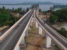
Mawlamyine is the main gateway to south eastern Myanmar. Thanlwin Bridge, the longest road and rail bridge in Myanmar is the most prominent landmark in the area. It stretches 11,000 feet (3,400 metres) over the Thanlwin River connecting the country's south eastern region with Yangon.[29] The city has central highway bus station. The city is connected to Pa-an in Kayin State in the north-east and Dawei and Myeik in Tanintharyi Division in the south by road.[30] Via Kawkareik, the city is also connected with Thai-Myanmar border town Myawaddy. Newly-opened Bogyoke Aung San Bridge (Bilu Kyun) connects Mawlamyine with nearby Bilu island, lies about 500 metres west off the shore of Mawlamyine.[31][32]
In Mawlamyine, motorcycles and tuk-tuk (Thone Bee in Burmese) motorized tricycles cumulatively registered for use as taxis. Mawlamyine is also served by bus networks which radiate mostly from the north to the south.
Railways
It was the rail head to Ye, linked to Yangon by rail only from Mottama (Martaban) across the river by ferry, but today connected by the Thanlwin Bridge (Mawlamyine) opened in April 2006.[14][33][34]
Mawlamyine Railway Station, which was reportedly built to the standards of an "ASEAN railway station", is the terminus of Myanmar Railways' Bago-Mawlamyine-Dawei line from Yangon.
Water transport
In colonial era, Mawlamyine (then Moulmein) port was served by European shipping companies including Scottish-owned British-India Steam Navigation Company and Irrawaddy Flotilla Company.
_01.jpg)
The port was important not only for inland navigation but also for international shipping. Rice and teak from sawmills at Mawlamyine were exported worldwide by those shipping companies.[35] The 1880 handbook of British-India Steam Navigation Company listed:
- Calcutta - Rangoon - Moulmein (started in 1857)[36]
- Moulmein - Penang - Malacca - Singapore (started in 1862)[37]
- Moulmein - Penang - Colombo - Bombay lines in operations.[38]
In 1894, the journey between Barr Street Jetty of Rangoon to the Main Wharf of Moulmein took about nine hours at a fare of 10 Rupees for second class.[39]
Nowadays, although much diminished from its past prominence, water-based transport still plays an important role in connecting between Mawlamyine and the immediate upstream towns. The Port of Mawlamyine is currently under the management of Myanma Port Authority and is located on the Thanlwin River about 28 nautical miles inland from the Kyaikkhame point on the Gulf of Martaban, 2 kilometers from Mawlamyine railway station.[40][41]
Cityscape
Around the city
Heritage buildings
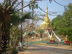
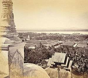
- Kyaikthanlan Pagoda: It was built in 875 AD during the reign of Mon King Mutpi Raja,[24] it was raised from its original height of 56 feet (17 metres) to the present 150 feet (46 metres) by successive kings including Wareru, founder of the Kingdom of Hanthawaddy Pegu.[24][42] In 1831, to prevent Moulmein's identity from fading away, Sitke Maung Htaw Lay, who later served as Magistrate of Moulmein restored the pagoda with the funds raised by public subscriptions.[43] Being situated on the range of hill, the pagoda commands the stunning view of the city, nearby islands, Gulf of Martaban, surrounding rivers and the limestone mountains of Kayin State in the east. Rudyard Kipling is believed to have written his famous "Lookin' lazy at the sea" line at this pagoda in 1890.[44]
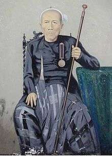 Magistrate of Moulmein Sitke Maung Htaw Lay (1776–1869)
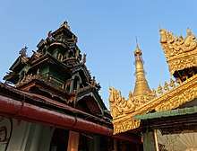 Architecture at Kyaik Than Lan Pagoda in 2014
 - U-zina Pagoda: The pagoda is one of the principal pagodas situated on the range of hill. According to legend, the pagoda contains a hair of Buddha and was built during the reign of King Ashoka, the great protector of Buddhism.[45] The U-zina pagoda was named after the sage, U-zina who restored it in 1838. Prior to this the pagoda had been known as Kyaik Pa-dhan pagoda.
- Princess Ashin Hteik Suhpaya's tomb: Princess Ashin Hteik Suhpaya (also known as Princess Myat Phaya Galay) who was the fourth daughter of King Thibaw, the last king of Konbaung dynasty returned to Burma from exile in 1915 and lived at her mansion on West Cantonment Road, Mawlamyine until her death in 1936.[46] Her tomb is located near Kyaikthanlan Pagoda. The remains of her son, Prince Taw Phaya Nge and her daughter, Princess Hteik Su Phaya Htwe were also buried in the tomb in the later years.
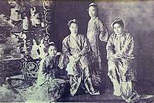 The four daughters of King Thibaw in 1914 (Princess Myat Phaya Galay on the left)
 - First Baptist Church: The church is Myanmar's first Baptist church and it was initially built in 1827 by the legendary Adoniram Judson, a 19th-century American missionary who compiled the first Burmese-English dictionary.[47] The church is regarded as a landmark for its significance to the Baptist movement worldwide.[48]
- St Matthew's Church: It was the first English Church (Anglican Church) built in Myanmar. It was initially erected in 1832 and the current handsome structure was rebuilt in 1887.[49][50] It was designed by the famous British architects St Aubyn & Wadling of London and the foundation stone was laid by Sir Charles Crosthwaite, Chief Commissioner of Burma.[51] It is of red brick, the capitals of interior pillars being stone, and is said to be a model of English Church at Dresden. George Orwell attended the church during his days as Imperial Policeman in Moulmein in 1926 and the church compound has grave stones of his relatives. During the Japanese conquest of Burma in WWII, the Japanese Army stored salt in the church. Though the church is still in use, it is in a state of decay and is in urgent need of conservation.[15]
- St Patrick's Church: The St Patrick's Roman Catholic church was built in 1829; the French constructed the clock tower of the church around 1854. St Patrick's school in the church compound was once a famous boarding school for the children of the elite in colonial times. The tragic love story of Thailand's Prince Sukkasem, the heir to the Lanna throne, and a Mon commoner girl started during his time at this school in the 1890s and was immortalised in Thai folk song and literature.[52][53]
- Police Commissioner Headquarters: Built in 1826 on a hill in Than Lwin Park. The impressive colonial building was the place where George Orwell worked as Assistant District Superintendent in 1926.[54]
- Old Mawlamyine Prison: The Mawlamyine's colonial-era prison was initially built in the 1830s. Sir Richard Hieram Sankey used to work there as Superintendent of the jail in 1860. George Orwell was believed to have witnessed hanging there and it is the setting of his short story "A Hanging (1931)".[55] During WWII, following the Fall of Singapore, Allied soldiers transferred from Changi Prison were held in the Mawlamyine Prison by the Imperial Japanese Army before they were sent to the notorious death railway construction.[56]
- Yadanabonmyint Monastery: It is also known as Queen Seindon Monastery. It is famous for its fine craftsmanship.
Islands
- Bilu Island (Belu-kyun): The local meaning of the island's name is Ogre Island. The island is famous for handicraft and Mon traditional culture.[57]
- Gaungsay Kyun Island (Shampoo Island): A tiny island lies between Mottama and the north bank of Mawlamyine is called Gaungsay Kyun island, literally: "Head Washing Island". In ancient times, the clear pristine water obtained from a small rocky outcrop of the island was carried to the palace and used by Burmese kings at royal hair-washing ceremonies during Thingyan.[58] In colonial days, the island was known in its European name "Crow Island" for being the home of all the crows in the city.
Others
- Mon State Cultural Museum (Mon Ethnic Cultural Museum)
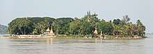
- Mottama (formerly Martaban): A small town located opposite to the north bank of Mawlamyine was the first capital of the Hanthawaddy Kingdom in the 13th and 14th centuries after the collapse of Pagan (Bagan) Empire in 1287. During Burmese–Siamese wars between the 16th and 18th centuries, Martaban was an important rallying spot for Burmese troops moving from Upper Burma to sack Ayutthaya Kingdom. Between 2nd-century BCE and 15th-century CE, Martaban was a main trading port in the historic Maritime Silk Road that connects Korea, China, Southeast Asia, the Indian subcontinent, Ceylon, Arabian peninsula, Horn of Africa and all the way to Egypt and eventually Rome or Europe.[59] The Martaban jars were imported and got its namesake from this Martaban port city as early as the fourteenth century.[60][61]
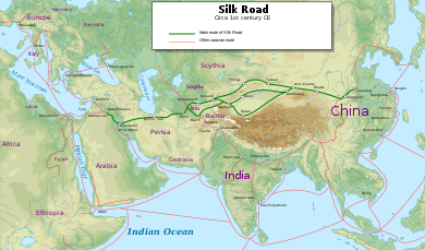 The Maritime Silk Road in the 1st century
 - Pa-Auk Forest Monastery (Pa-Auk Tawya): The original Pa-Auk Forest Monastery is located in a forest near Pa-Auk village along the Taung Nyo Mountain range 15 kilometers southeast of Mawlamyine.[62][63] The monastery is famous for the practice of meditation. 500-1000 meditators from over 20 countries reside in the monastery.[64][65]
- Win Sein reclining Buddha: 29 km south of Mawlamyine is the world's largest reclining Buddha at Mudon. It is approached by a roadway with 500 life size statues of Arahant disciples of Buddha and a hall whose chamber walls display scenes of Buddha's lifetime, and the underworld.[25]
- Thanbyuzayat War Cemetery: 64 kilometers south of Mawlamyine is prisoners-of-war cemetery and the notorious death railway connected with the Bridge over the River Kwai. The cemetery contains the graves of 3,770 British, Australian, Dutch and other soldiers. It was formally opened on 10 December 1946 by General Aung San and then Governor Sir Hubert Rance.[66]
Economy
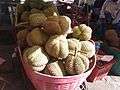
Mawlamyine is famous for its tropical fruits[5] and for its cuisine[14] as indicated in the popular Burmese expression, "Mandalay for the speaking, Yangon for the bragging, and Mawlamyine for the eating." (မန္တလေးစကား ရန်ကုန်အကြွား မော်လမြိုင်အစား) Among its tropical fruits, Mawlamyine pomelo, durian and rambutan are the most famous and traded countrywide.
Mawlamyine had several sawmills and rice mills as teak and rice were transported down the Salween. It was once a busy shipbuilding center and remains an important port. At least one major British shipping line had some of their ships built here. The teak "country-built" ships generally had a longer service life than those constructed from European hardwoods.[67] The city had a solar-powered plant for extracting salt from seawater and a diesel electric plant.[14] On the night of 1 December 2008, a fire that started from a floating restaurant destroyed the larger of city's two markets called the lower bazaar.[68]
Industry
The city has two industrial zones. Of two, the newly-opened Kyauktan industrial zone features a variety of different business enterprises, including zinc, barbed wire, ready-mix cement, food and drink production, textiles, gold purification, ice factories, shoe production facilities, furniture enterprise, plastic enterprises, cool seafood storage and car accessory businesses.[69]
As a cross-border investment, the state-of-the-art combined-cycle gas power plant in Mawlamyine was constructed by Singapore's United Overseas Bank (UOB) backed Singapore company Asiatech Energy.[70] The Mawlamyine power plant brings a sustainable supply of power to residents and businesses in Mon State.
In July 2017, to make the country's oil and gas industry more efficient, the Myanmar Investment Commission (MIC) granted an approval to a subsidiary of Singapore-based firm to construct an offshore supply base in the 46 acres of river front land of Mawlamyine.[71][72] It would provide a wide range of services to the operators of oil and gas fields in the waters off the coast in the Bay of Bengal.[73]
Transport hub
Mawlamyine is the western terminus and an important part of the East-West Economic Corridor. The 1450-kilometre east–west economic corridor links the South China Sea at Da Nang to Mawlamyine through Laos and Thailand.[74] By using the East-West Economic Corridor, the travel time between Bangkok and Yangon is just three days, compared with the two to three weeks needed for conventional marine transportation via the Straits of Malacca.[75] Japan's Nippon Express started land transportation services between Thailand and Myanmar in 2016.
Flora
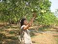
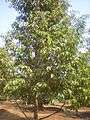 Durian plantation
 Moulmein Rosewood
 Burmese grape
Culture
Mawlamyine provides a multicultural dimension despite a Buddhist Mon majority. Buddhist cultural dominance is as old as Mawlamyine, but the British annexation and American missionaries in the early 19th century introduced Christianity. Many of the relics of the British Raj remain along with Hindu temples, Chinese temples, mosques and even a slice of Americana, reflecting Mawlamyine's great diversity.[76]
_-_panoramio_(50).jpg)
The First Baptist Church in Mawlamyine was constructed in 1827 by the legendary Adoniram Judson, the first Caucasian Protestant missionary sent from North America to Myanmar.[77] The building is a masterful blend of Western and local elements, with the materials and building technology speaking directly to Mon cultural traditions and crafts expertise. In 2015, the U.S. Embassy in Myanmar announced that it gave an award of $125,000 to World Monuments Fund (WMF) to restore the historic First Baptist Church in Mawlamyine through the Ambassadors Fund for Cultural Preservation.[78]
The Mon State Cultural Museum exhibits the ancient cultural relics of Mon people and divans used by a Konbaung princess who resided in Mawlamyine.
Education
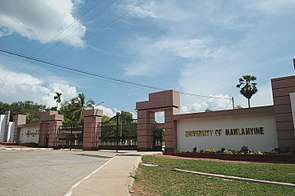
Mawlamyine has 13 public high schools, two institutes, a college and three universities.
The University of Mawlamyine, which was established in 1953 is the major university for the south eastern region and offers both bachelor's and master's degree programs in liberal arts and sciences. The University of Mawlamyine is the third oldest Arts and Science university in the country after Yangon University (est 1878) and Mandalay University (est 1925). Mawlamyine University is one of few universities in Myanmar, offering a degree in Marine Science. Its Marine Science Laboratory in Setse, a coastal town about 83 km south of Mawlamyine was the first of its kind in Myanmar.[79] Technological University (Mawlamyine) offers technological and engineering courses. The Mawlamyine campus of Yezin Agricultural University, which is administered by Ministry of Agriculture, Livestock and Irrigation (MOALI) offers agriculture courses.[80] Government Technical Institute (Mawlamyine), which also offers vocational engineering courses located in outskirts of the city. Mawlamyine Education College and Mawlamyine Institute of Education are also located in the city.[81]
The St. Patrick's School (now B.E.H.S No.5) founded by the De La Salle Brothers in 1860 and Shin Maha Buddhaghosa National School (now B.E.H.S No.9) founded in 1899 are popular public high schools in the city.[82]
The first international student of Bucknell University, Class of 1864, Maung Shaw Loo—born in 1839 in Mawlamyine (then Moulmein)—was the first Myanmar medical doctor and native Myanmar to study Western Medicine and to study in the United States.[83][84]
Sports
The 10,000-seat Yamanya Stadium is one of the main venues for popular local and regional football tournaments. The stadium is also a home for Southern Myanmar F.C, a Myanmar National League (MNL) football club.
Health care
Public Hospitals
- Mawlamyine Women and Children Hospital (former Ellen Mitchell Memorial Hospital)
- Mawlamyine General Hospital
- Mawlamyine Christian Leprosy Hospital
- Mawlamyine University Hospital[85]
- Mawlamyine Traditional Medicine Hospital
International relations
Sister cities
Mawlamyine established a Friendship City agreement with Fort Wayne, Indiana, United States in 2016.[86] As a co-operation between the two cities, student exchange between Mawlamyine University and IPFW of Fort Wayne started in early 2017.
Others
A primary road in Novena, Singapore and a road (Solok Moulmein) in George Town, Malaysia were named after the city's old name, Moulmein.
Gallery
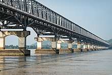 Bridge over Salween River
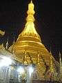 Kyaik Tan Lan pagoda at night
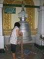 Old bell donated by Mon King in AD 1533
 Sasana 2500 pagoda at night
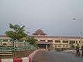 Mawlamyine Railway Station
 Thanlwin public park
.jpg) Holy Family Cathedral
Holy Family Cathedral.jpg) Sunset over Salween (Than Lwin) River
Sunset over Salween (Than Lwin) River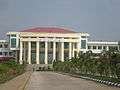 Technological University (Mawlamyine)
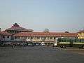 Mawlamyine Coach Station
_-_panoramio_(51).jpg) Queen Sein Don Monastery
Queen Sein Don Monastery A roundabout in Mawlamyine
_-_panoramio_(43).jpg) Aerial view of the city
Aerial view of the city_-_panoramio_(42).jpg) St Patrick's School (now BEHS 5)
St Patrick's School (now BEHS 5)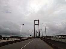
See also
- University of Mawlamyine
- Thanlwin Bridge (Mawlamyine)
- Mon people
- Attaran Bridge (Mawlamyine)
- Sittoung Bridge (Bilin)
- Kyaiktiyo Pagoda
References
- The 2014 Myanmar Population and Housing Census The Union Report Census Report Volume 2 (PDF). Department of Population, Ministry of Immigration and Population. May 2015. p. 59.
- "National Telephone Area Codes". Myanmar Yellow Pages. Archived from the original on 2010-11-20.
- "Myanmar: largest cities and towns and statistics of their population:calculation 2010". Archived from the original on 19 September 2012. World Gazetteer
- "Population of Cities in Myanmar (2017)". worldpopulationreview.com. Retrieved 2017-10-22.
- "Mawlamyine or Moulmein". allmyanmar.com. Retrieved 2009-02-03.
- Banyar, Ko (7 November 2013). "မွန်တို့ဌာနေ ရာမည တိုင်းက မွန် အခေါ်အဝေါ်များ". Phophtaw News Association.
- Tun, Than (1988). "Observations on the Translation and Annotation of the Royal Orders Of Burma". Crossroads: An Interdisciplinary Journal of Southeast Asian Studies. 4 (1): 91–99. JSTOR 40860260.
- Dictionary of Modern Spoken Mon by H.L. Shorto (1962, Oxford University Press).
- Myanmar Travel Information. Accessed 16 August 2015
- Cotton, Sophia Anne; Cotton, George Edward Lynch (1871). Memoir of George Edward Lynch Cotton, D.D., Bishop of Calcutta, and Metropolitan : with selections from his journals and correspondence. University of California Libraries. London : Longmans, Green.
- Shorto, H L (1963). The 32 myos in the medieval Mon kingdom. Bulletin of the School of Oriental and African Studies. p. 575.
- Aung, Htin (1967). A History of Burma. New York and London: Cambridge University Press. p. 106.
- Rajanubhab, Damrong (2001). Our Wars With the Burmese. Bangkok,Thailand: White Lotus. pp. 145–147. ISBN 9747534584.
- "Moulmein". Encyclopædia Britannica online. Retrieved 2009-02-03.
- "Moulmein, Myanmar". 2017-03-09. Retrieved 2017-06-12.
- McPherson, Kenneth (2002). Port Cities as Nodal Points of Change. Columbia University Press. pp. 75–95.
- Bird, George W. (1897). Wanderings in Burma. University of Michigan. Bournemouth [Eng.] F.J. Bright & son; London, Simpkin, Marshall, Hamilton, Kent & co., ltd.
- "Moulmein - Encyclopedia". theodora.com. Retrieved 2017-10-11.
- Archives, The National. "The Discovery Service". discovery.nationalarchives.gov.uk. Retrieved 2017-10-11.
- "1888 Moulmein". ABL Directories. Retrieved 2017-10-11.
- Nostitz, Pauline; Sturge, G. (George); Hochstetter, Ferdinand von (1878). Travels of Doctor and Madame Helfer in Syria, Mesopotamia, Burmah and other lands. Francis A. Countway Library of Medicine. London : Richard Bentley & Son.
- Zollner, Hans-Bernd (2002). "Germans in Burma, 1837-1945". The Journal of Burma Studies. Northern Illinois University. 7: 34.
- Mawlamyine.com Kyaikthanlan pagoda page Accessed 16 August 2015.
- Happy Footprints Archived 2016-09-18 at the Wayback Machine. Accessed 16 August 2015
- W. Vivian De Thabreuw, Buddhist Monuments and Temples of Myanmar and Thailand (Authorhouse, 11 March 2014). E-book. ISBN 9781491896228.
- Tinker, Hugh. Union of Burma. p. 325.
- "Myanmar Climate Report" (PDF). Norwegian Meteorological Institute. pp. 23–36. Archived from the original (PDF) on 8 October 2018. Retrieved 28 October 2018.
- "Moulmein (Myanmar)" (PDF). Centro de Investigaciones Fitosociológicas. Retrieved 13 December 2018.
- "Welcome to Mawlamyine". Retrieved 2008-08-30.
- "Myanmar (Burma) Maps - Major country roads". Asterism. Retrieved 2009-02-03.
- mizzima (2017-06-14). "The Bilu Kyun Bridge controversy". Mizzima. Retrieved 2017-08-05.
- "Bogyoke Aung San Bridge inaugurated | Global New Light Of Myanmar". www.globalnewlightofmyanmar.com. 2017-05-09. Retrieved 2017-08-05.
- "Train travel in Myanmar(Burma)". seat61.com. Retrieved 2009-02-03.
- "Mon State". Asterism. Retrieved 2009-02-03.
- "Irrawaddy Flotilla". Mrs Findlays Broadwood Square Piano. Retrieved 2017-07-30.
- Brittain, Colin. "British India Steam Navigation Company - Part One". www.eskside.co.uk. Retrieved 2017-07-30.
- Jones, Stephanie (1986). Two Centuries Of Overseas Trading. Palgrave Macmillan UK. p. 42.
- Swiggum, Sue. "British India Steam Navigation Company". www.theshipslist.com. Retrieved 2017-07-30.
- Wanderings in Burma. archive.org. Bournemouth [Eng.] F.J. Bright & son; London, Simpkin, Marshall, Hamilton, Kent & co. 1897. Retrieved 2017-07-30.
- "Study underway for new port in Yangon, CM says". Mizzima Myanmar News and Insight. Retrieved 2019-09-17.
- "2.1.2 Myanmar Port of Mawlamyine, Mon state - Logistics Capacity Assessment - Digital Logistics Capacity Assessments". dlca.logcluster.org. Retrieved 2019-09-17.
- Bird, G W (1897). Wanderings in Burma. p. 204.
- Wai Wai, Myaing (2005). A Journey in Time: Family Memoirs (Burma, 1914–1948). iUniverse. p. 210. ISBN 9780595356515.
- "Kyaik Than Lan". Travelfish. Retrieved 2017-06-13.
- "Wanderings in Burma". seasiavisions.library.cornell.edu. Retrieved 2017-07-29.
- "Burma's Last Royals - Los Angeles Review of Books". Los Angeles Review of Books. Retrieved 2017-06-12.
- "First Baptist Church of Mawlamyine". World Monuments Fund. Retrieved 2017-06-13.
- "Baptist church restoration a mixed blessing for Myanmar".
- "Moulmein, Myanmar". 2017-03-09. Retrieved 2017-06-13.
- "Wanderings in Burma - Southeast Asia Visions". seasiavisions.library.cornell.edu. Retrieved 2017-07-27.
- Larkin, Emma (2005). Finding George Orwell in Burma.
- "Westward, ho!". Bangkok Post. Retrieved 6 July 2019.
- Duangnee, Phoowadon (27 Jul 2016). "History Carved In Stone". The Nation.
- Meyers, Jeffrey (2010). Orwell: Life and Art. University of Illinois Press. p. 19.
- "Here be monsters: Travelling to Ogre Island". The Myanmar Times. Retrieved 2019-07-05.
- Crager, Kelly (2008). Hell Under the Rising Sun: Texan Pows and the Building of the Burma-Thailand Death Railway. Texas A&M University Press. pp. 68–77.
- "Bilu Island". Travelfish. Retrieved 2017-06-13.
- Scott, James George (1896). The Burman, his life and notions. University of California Libraries. London, Macmillan and co., limited.
- "Maritime Silk Road Archives". SEAArch - Southeast Asian Archaeology. Retrieved 2019-09-11.
- "GLOSSARY: Martaban wares". gotheborg.com. Retrieved 2019-09-10.
- "Martaban Jar". www.roots.sg. Retrieved 2019-09-10.
- "Pa-Auk Forest Monastery". www.paaukforestmonastery.org. Retrieved 2017-06-13.
- "Pa-Auk Forest Monastery". www.paaukforestmonastery.org. Retrieved 2017-06-13.
- "Pa-Auk Forest Monastery". www.paaukforestmonastery.org. Retrieved 2017-07-27.
- "40-Day Meditation Retreat at Pa-Auk Tawya, Burma". UP Development. 2014-09-17. Retrieved 2017-07-27.
- "Myanmar Guide & Reviews". myanmars.net. Retrieved 2017-07-27.
- Smith, C. Fox (1925). Ship Alley. Methuen. pp. 80-91.
- Lawi Weng. "Fire Destroys Moulmein Market". The Irrawaddy, December 2, 2008. Retrieved 2009-02-03.
- "New Industrial Zone in Mon State to open this month | Global New Light Of Myanmar". www.globalnewlightofmyanmar.com. 2016-03-16. Retrieved 2017-08-20.
- "Powering up Myanmar". BBC Capital. Retrieved 2017-08-20.
- mizzima (2017-05-27). "Myanmar Offshore Supply Base Development: Further Chaos or Progress?". Mizzima. Retrieved 2017-09-08.
- "Myanmar Offshore Supply Base Ltd (MOSB) - Myanmar opens arms for the first foreign company to build an oil and gas supply base". Electric Energy Online. Retrieved 2017-09-08.
- "The race to build a supply base". The Myanmar Times. Retrieved 2017-09-08.
- "East-West Economic corridor still in planning stage: ADB official". The Myanmar Times. Retrieved 2017-09-08.
- "Roads can convert Myanmar from economic void to hub- Nikkei Asian Review". Nikkei Asian Review. Retrieved 2017-09-08.
- Gray, Denis D. (2017-04-22). "Myanmar's ex-colonial capital captivates with faded glory | TheRecord.com". TheRecord.com. Retrieved 2017-08-08.
- "First Baptist Church of Mawlamyine". World Monuments Fund. Retrieved 2017-06-12.
- "U.S. Embassy Announces Project to Restore the Historic First Baptist Church in Mawlamyine [Burmese] [Mon] | U.S. Embassy in Burma". U.S. Embassy in Burma. 2015-09-14. Retrieved 2017-06-12.
- "l". 2009-01-06. Archived from the original on 2009-01-06. Retrieved 2017-06-12.
- "Mawlamyine Campus – Yezin Agricultural University". www.yau.edu.mm. Retrieved 2017-09-04.
- "MODiNS [ Myanmar Online Information ]". www.modins.net. Retrieved 2017-06-12.
- "The New Light of Myanmar (Sunday, November 21, 1999)". www.burmalibrary.org. Retrieved 2017-06-13.
- "Maung Shaw Loo". Bucknell University. Retrieved 2009-02-03.
- "Dr. M Shaw Loo" "The Myanmar Net", Myanmar, Retrieved on 30 March 2014
- "ဘွဲ့လွန်သင်တန်းများဝင်ခွင့်အရည်အချင်းစစ်စာမေးပွဲဖြေဆိုခွင့်ရရှိသူများ၏ခုံအမှတ်စာရင်း". University of Medicine 1, Yangon.
- "Fort Wayne Sister Cities to sign Myanmar friendship agreement". The News-Sentinel. 26 January 2016. Retrieved 30 March 2016.
External links
| Wikimedia Commons has media related to Mawlamyaing. |
| Wikivoyage has a travel guide for Mawlamyine. |
| Wikisource has the text of the 1905 New International Encyclopedia article Maulmain. |
Mawlamyine | ||
| Preceded by None |
Capital of British Tenasserim 24 February 1826 – 31 January 1862 |
Succeeded by Yangon |
Capital: Mawlamyine | |
|
Capital: Mawlamyine | ||
| Mawlamyine District |  | |
| Thaton District | ||
| Cities, towns, and villages |
| |
| 2,000,000 and more | |
|---|---|
| 1,000,000–1,999,999 | |
| 500,000–999,999 |
|
| 200,000–499,999 | |
| 100,000–199,999 | |
| Authority control |
|
|---|