Thanlwin Bridge (Mawlamyine)
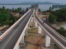
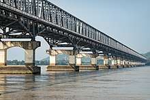
Thanlwin Bridge (Mawlamyaing) was the longest bridge in Myanmar before the construction of Pakouku Bridge[1] and connects the city of Mawlamyaing with Mottama. Constructed at the confluence of the Thanlwin River, the Gyaing River and the Attayan River in Mon State, the bridge has a two-mile (3 km)-long motor road and four-mile (6 km)-long railroad as well as pedestrian lanes.[2]
Thanlwin (Mawlamyaing) Bridge | |
|---|---|
 သံလွင်တံတား (မော်လမြိုင်) | |
| Coordinates | 16°30′40″N 97°37′04″E |
| Carries | 2 lanes (SB and NB), 1 rail track (14 ft), 2 sidewalks(6 ft each) |
| Crosses | Salween River via Shampoo Island |
| Locale | Mawlamyaing and Mottama, Mon State |
| Official name | Thanlwin Bridge, (Mawlamyaing) |
| Maintained by | Ministry of Transportation |
| Characteristics | |
| Design | Steel Frame Truss bridge, & Cantilever Bridges and Access Bridges |
| Total length | Road bridge 1,624 ft (495 m) Mawlamyaing Bank, 2,252 ft (686 m) Mottama Bank, Main Frame 7,699 ft (2,347 m) or 2.2 miles (3.1 km) (total bridge) Rail bridge 6,442 ft (1,964 m) Mawlamyaing Bank, 7,498 ft (2,285 m) Mottama Bank, Main Frame 7,699 ft (2,347 m), 21,618 ft (6,589 m) or 4.1 miles (total bridge) |
| Width | 2 traffic lanes ~28 feet (~ 8.5 m), single rail track~14 ft(~4.3 m), 2 Sidewalks (~12 ft) |
| History | |
| Construction start | 18 March 2000 |
| Construction end | 18 April 2005 |
| Opened | 18 April 2005 |
 The Bridge linking a 708 km highway | |
The approach structure of the rail bridge on Mawlamyaing bank is 1.22 miles (1,960 m) long, and on Mottama bank is 1.42 miles (2,290 m) long. The total length of the rail bridge is 4.1 miles (6,600 m) long.[3] The bridge was designed and built by Ministry of Construction.[2]
See also
- Rail transport in Myanmar
- Myanmar Railways
- Myanmar Longest and Largest Bridge
References
- "Pakouku Bridge".
- "Thanlwin Bridge (Mawlamyine), longest and largest in Myanmar, emerges to serve interests of State and region". 2005-02-05. Archived from the original on 2005-10-25.
- "Thanlwin Bridge (Mawlamyine) rail bridge opens". The New Light of Myanmar. 2006-04-19. Archived from the original on 2007-02-20.
This article is issued from Wikipedia. The text is licensed under Creative Commons - Attribution - Sharealike. Additional terms may apply for the media files.