Morwell, Victoria
Morwell is a town in the Latrobe Valley area of Gippsland, in South-Eastern Victoria, Australia approximately 149 km (93 mi) east of Melbourne.
| Morwell Victoria | |||||||||||||||
|---|---|---|---|---|---|---|---|---|---|---|---|---|---|---|---|
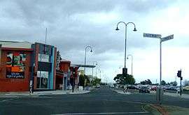 Corner of Hazelwood and Commercial Roads, Morwell | |||||||||||||||
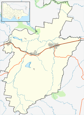 Morwell Location in City of Latrobe | |||||||||||||||
| Coordinates | 38°14′S 146°24′E | ||||||||||||||
| Population | 13,771 (2016 census)[1] | ||||||||||||||
| Established | 1870s | ||||||||||||||
| Postcode(s) | 3840 | ||||||||||||||
| Elevation | 80 m (262 ft) | ||||||||||||||
| Location | 149 km (93 mi) from Melbourne 59km (36mi) from Leongatha | ||||||||||||||
| LGA(s) | City of Latrobe | ||||||||||||||
| State electorate(s) | Morwell | ||||||||||||||
| Federal Division(s) | Gippsland | ||||||||||||||
| |||||||||||||||
Morwell has a population of approximately 13,770 people.
It is both the seat of local government and administrative centre for the City of Latrobe. Morwell is central to the Latrobe Valley urban area which has a population of approximately 73,000 and as such has become home to many of the greater urban area's civic institutions, administrative functions and infrastructure.
The city is known for its role as a major energy production centre for Victoria as the centre of a major coal mining and fossil-fuel power generation industry.
History
The earliest inhabitants of the Morwell district were the Gunai (sometimes spelled Kurnai) Indigenous Australians. Their first contact with Europeans would have been with pastoralists who came south from the Monaro region of New South Wales in the 1840s in search of pasture for their stock.
In 1841, McMillan and Strzelecki made journeys of exploration through the region which would later be named Gippsland and during the 1840s the squatting runs of Maryvale, Merton Rush and Hazelwood were taken up in the area which is now Morwell.
The name of the Morwell River is allegedly the anglicised form of the Aboriginal words more willie meaning woolly possum. In turn, this became the name for the public house by the river and the early settlement nearby.[2]
The 1870s were a time of railway building in Victoria. In 1873 the government approved the construction of a railway line from Melbourne to Sale and it was this decision which gave rise to the development of the township of Morwell. The railway station was approximately 3 miles from the settlement by the river, leading to new development occurring around the railway station.[2]
The first public sale of land in the town took place in January 1879 but there were at least ten traders operating in the town by that time, a Post Office in the township having been open since 1875 (an earlier PO having served the rural area from 1870 to 1873). On 1 January 1880 Morwell PO was renamed Morwell Bridge and Morwell Railway Station PO (open since 1877) became the main Morwell PO.[2][3]
A brickworks and a pottery were established in the 1880s, a butter factory was built in 1890 and a cordial factory.
Even in the 1880s, coal was seen to be of importance to Morwell. In 1888 two coal mining companies were established—The Great Morwell Coal Mining Company and the Maryvale Proprietary Coal Mining Company. Both these companies produced steam coal and were part of the industrial growth of the town which included timber getting, food processing (butter and cordial factories), brick and pottery manufacture and the transport of goods along the main railway line. Fires in the commercial area in 1890 and 1912 caused major damage to shops. This led to the formation of the Morwell Waterworks Trust and in December 1913 a town water supply from Billy's Creek was connected.
The development of the Yallourn open cut coal mine and power station in the 1920s contributed to Morwell's development, providing employment and trade.
Work on the Morwell power station and briquette works commenced in 1949 by the State Electricity Commission of Victoria (SECV), when field works on the Morwell open cut mine commenced, and briquette production equipment was ordered from Germany. It was originally known as the Morwell Power Station and is now known as Energy Brix. Production at the plant started in 1956, with the briquettes produced used for domestic and industrial use. As well as this a town gas production for Melbourne at an adjacent gasworks by the Gas and Fuel Corporation of Victoria was built.
The 1980s were a growth period for the township of Morwell. Schools were built to educate the children of families settling in the area.
A major Research and Development project into the conversion of brown coal into oil, (Brown Coal Liquefaction Victoria or BCLV) was established in Morwell in 1983/84. Funded by the Japanese Government at a cost of over one billion dollars this project established a 50 tonne per day pilot plant which ran until 1991. The project saw several hundred Japanese families move to the area and led to the establishment of a unique educational experiment in the form of a Japanese/Australian combined curriculum at the Commercial Road Primary School.
Thriving on the success of the power industry, Morwell developed into a city offering substantial housing and financial opportunities for its many residents. With the general growth of the Latrobe Valley, Morwell's success appeared destined to continue. However, the approval by the City of Morwell to build the Mid Valley Shopping Centre complex away from the CBD led to the decline of the CBD, with many empty shopfronts the result. Further, restructuring and privatisation of the State Electricity Commission in the 1990s led to massive job losses in the region, which accelerated the decline of Morwell's central business district. Many shops are now empty and in a state of disrepair.
Amalgamation of the local councils following a Statewide review of local government boundaries in 1994 saw Morwell become part of the City of Latrobe and the civic centre established in Traralgon. With the re-establishment of an elected council, the civic centre was moved back to Morwell and the new council building constructed in 2005 in the hope of leading to a revitalisation of the city centre. Unfortunately, that revitalisation failed to eventuate. The new justice precinct was completed in 2006 and has somewhat increased CBD activity as alleged criminals come to the Morwell justice precinct for processing through the Justice System.
Figures released by the Australian Bureau of Statistics in March 2011 show the average wage of Morwell residents to be the lowest of the three major Latrobe Valley towns.[4]
Morwell is the headquarters of the Central Gippsland Institute of Technical and Further Education. It contains a major regional art gallery with an excellent local collection and is noted for its extensive rose gardens. Nearby at Churchill is the Gippsland Campus of Federation University. A commemorative bust of Lt Gen Sir Stanley Savige was erected in 2006. Born in Morwell, Savige founded Legacy Australia following World War 1 to assist widows and families of servicemen.
Morwell is home to the Morwell Centenary Rose Garden, a parkland of over 2 hectares on a former railway reserve that showcases over 3500 roses. In 2009 the garden was presented an 'Award of Garden Excellence' by the World Federation of Rose Societies.
Geography
Climate
Morwell experiences an oceanic climate (Köppen climate classification Cfb). Nights in Morwell are about 2 °C colder than in Melbourne[5]
| Climate data for Morwell | |||||||||||||
|---|---|---|---|---|---|---|---|---|---|---|---|---|---|
| Month | Jan | Feb | Mar | Apr | May | Jun | Jul | Aug | Sep | Oct | Nov | Dec | Year |
| Record high °C (°F) | 45.1 (113.2) |
46.3 (115.3) |
40.4 (104.7) |
35.0 (95.0) |
26.7 (80.1) |
23.5 (74.3) |
21.8 (71.2) |
26.8 (80.2) |
31.0 (87.8) |
35.1 (95.2) |
38.6 (101.5) |
42.2 (108.0) |
46.3 (115.3) |
| Average high °C (°F) | 26.2 (79.2) |
26.5 (79.7) |
24.4 (75.9) |
20.5 (68.9) |
16.9 (62.4) |
14.2 (57.6) |
13.6 (56.5) |
14.9 (58.8) |
16.9 (62.4) |
19.3 (66.7) |
21.6 (70.9) |
24.0 (75.2) |
19.9 (67.8) |
| Average low °C (°F) | 12.5 (54.5) |
12.7 (54.9) |
11.1 (52.0) |
8.5 (47.3) |
6.6 (43.9) |
4.4 (39.9) |
3.7 (38.7) |
4.3 (39.7) |
5.8 (42.4) |
7.4 (45.3) |
9.4 (48.9) |
11.1 (52.0) |
8.1 (46.6) |
| Record low °C (°F) | 1.8 (35.2) |
1.9 (35.4) |
1.9 (35.4) |
−0.5 (31.1) |
−2.6 (27.3) |
−3.6 (25.5) |
−4.8 (23.4) |
−3.4 (25.9) |
−2.1 (28.2) |
−2.3 (27.9) |
0.6 (33.1) |
1.7 (35.1) |
−4.8 (23.4) |
| Average precipitation mm (inches) | 50.1 (1.97) |
39.2 (1.54) |
43.9 (1.73) |
57.1 (2.25) |
51.6 (2.03) |
58.4 (2.30) |
66.4 (2.61) |
62.9 (2.48) |
78.4 (3.09) |
72.8 (2.87) |
75.0 (2.95) |
68.6 (2.70) |
724.4 (28.52) |
| Source: [6] | |||||||||||||
Governance
At local level, Morwell is governed by the City of Latrobe and is both the seat of local government and administrative centre. It is represented at local level by three wards – Rintoull in the city's centre; Tanjil, the north and west; and Firmin, the south.
In the Government of Victoria it is represented in the Victorian Legislative Assembly by the Electoral district of Morwell. The state is responsible for law and order in Morwell. The Latrobe Valley Law Courts located opposite council headquarters in Commercial Road which has branches for the Supreme Court of Victoria, Magistrates' Court of Victoria and County Court of Victoria.[7] It is served by a single Victoria Police police station on Hazelwood Road.[8]
In the Government of Australia, it is represented in Parliament of Australia by the Division of Gippsland.
Education
Morwell has education facilities from preschool education through to vocational education and training. University-level qualifications are available nearby at Federation University Australia, Gippsland campus which is located in the adjacent town of Churchill. Other education and training provider are located in the wider Latrobe Valley urban area. The city has 4 primary schools - Morwell Central Primary School, St Vincent De Paul Primary, Sacred Heart Primary and Morwell Park Primary and a single junior secondary school – Kurnai College Morwell Campus (est 1963). TAFE study in Morwell is available via TAFE Gippsland (initially GippsTAFE, then Federation Training later), as well as apprenticeships and traineeships through Apprenticeships Group Australia.
Transport
Road transport and the motor vehicle is the main form of transport. The Princes Freeway (A1) bypasses the town to the south while the old Princes Highway which once passed through east–west through its centre is now Princes Drive and Commercial Road. The highway connects Morwell with other Latrobe Valley cities including Moe to the west and Traralgon to the east. Other main roads include the Strzelecki Highway (B460) running south toward Leongatha.
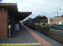
Rail transport includes both passenger rail and freight rail. The town's only station is Morwell railway station which is on the Bairnsdale line.[9] Both the Traralgon V/Line rail service and the Bairnsdale V/Line rail service stop there with a two way hourly service. Travel time to Melbourne ranges from approximately 109 minutes during peak travel times.[10]
General aviation operates from Latrobe Regional Airport which services the whole Latrobe Valley urban area.
Sport
Australian rules football is popular in Morwell. There are two senior clubs in the city: the Morwell Football Club (est 1905) based at the Morwell Recreation Reserve, compete in the Gippsland Football League, while the Morwell East Football Club (est 1973), based at the Morwell East Football Ground compete in the Mid Gippsland Football League. The Morwell Football Ground is home to the Gippsland Power (est 1993) which compete in the TAC Cup and has hosted Australian Football League pre-season matches in 2005 and 2010.
Cricket is also popular with two senior cricket clubs, Morwell and Latrobe, the latter of which Peter Siddle played for in his younger days.
Soccer has a long history in Morwell. The Morwell Falcons were formed in 1961 and eventually reached the National Soccer League which was the top league in Australia. Although they disbanded in 2001 an offshoot club, Falcons 2000, was formed as a direct descendant of the original club and continue to this day. The club plays in the Latrobe Valley Soccer League which is the eighth level of soccer in Victoria, and the ninth nationally. The club's home ground is Latrobe City Stadium.
Fortuna 60 and Morwell Pegasus both compete in the same league as the Falcons 2000. Their home grounds are Crinigan Road South Reserve and Ronald Reserve respectively.
The Morwell Cougars Baseball Club usually forms teams in three senior grades and all junior grades of the Latrobe Valley League. Their diamonds in Toners Lane are the only dedicated diamonds in the League.
American Football, also known as "Gridiron", is played at Maryvale Recreation Reserve. This is also the home of the local club Gippsland Gladiators which has been based there since 2010, competing in Division 2, of the Gridiron Victoria league.
There is also a 25-metre indoor swimming pool, used by the local swimming club for competitive swimming.
Golfers play at the course of the Morwell Golf Club on Fairway Drive.[11]
Media
Commercial radio stations 531 3GG, 94.3/97.9 Hit FM, TRFM & Gold 1242 service Morwell and the greater Gippsland region. Federal government owned ABC Gippsland broadcasts on 100.7FM and community station Gippsland FM (Formerly 3GCR) on 104.7FM. Gippsland FM is the only station in the region with a studio complex in Morwell.
Notable people
- Ben Ainsworth, AFL Footballer
- John Hutchinson, Coach and former Soccer player
- Chips Mackinolty, Radical poster artist and journalist
- Paul Morris, Motor racer
- Bryan Quirk, Australian footballer
- Peter Siddle, Cricketer
- Archie Thompson, Soccer player
- Vin Waite, Australian footballer
- Rocky Mattioli, Italian-Australian World Champion Boxer
- John Trevorrow, Australian champion Road cyclist.
See also
References
- Australian Bureau of Statistics (27 June 2017). "Morwell (State Suburn)". 2016 Census QuickStats. Retrieved 4 November 2017.

- THE NAME OF MORWELL. (9 December 1940). Gippsland Times (Vic. : 1861 – 1954), p. 8. Retrieved 14 October 2013, from http://nla.gov.au/nla.news-article63276947
- Premier Postal History, Post Office List, retrieved 11 April 2008
- "Latrobe Valley Voice".
- "Melbourne Airport". Climate statistics for Australian locations. Bureau of Meteorology. February 2014.
- "Climate statistics for Morwell (Latrobe Valley Airport)". Australian Bureau of Meteorology.
- http://www.magistratescourt.vic.gov.au/find/court+locations/magistrates+-+latrobe+valley+-+map
- Police, Victoria. "Victoria Police - Morwell". www.police.vic.gov.au.
- "PTV Regional Rail Lines and Maps". PTV. Retrieved 26 November 2014.
- Traralgon - Melbourne Public Transport Victoria
- Golf Select, Morwell, retrieved 11 May 2009
External links
| Wikimedia Commons has media related to Morwell, Victoria. |