Montville, Maine
Montville is a town in Waldo County, Maine, United States. The population was 1,032 at the 2010 census.
Montville, Maine | |
|---|---|
| Motto(s): "The Way Life Is"[1] | |
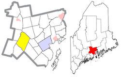 Location of Montville (in yellow) in Waldo County and the state of Maine | |
| Coordinates: 44°25′48″N 69°17′6″W | |
| Country | United States |
| State | Maine |
| County | Waldo |
| Area | |
| • Total | 43.14 sq mi (111.73 km2) |
| • Land | 42.66 sq mi (110.49 km2) |
| • Water | 0.48 sq mi (1.24 km2) |
| Elevation | 469 ft (143 m) |
| Population | |
| • Total | 1,032 |
| • Estimate (2012[4]) | 1,034 |
| • Density | 24.2/sq mi (9.3/km2) |
| Time zone | UTC-5 (Eastern (EST)) |
| • Summer (DST) | UTC-4 (EDT) |
| ZIP code | 04941 |
| Area code(s) | 207 |
| FIPS code | 23-46790 |
| GNIS feature ID | 0582605 |
| Website | Town of Montville, Maine |
History
Montville was incorporated on February 18, 1807,[5] and was named for the French word for "mountain town".[6]
Geography
According to the United States Census Bureau, the town has a total area of 43.14 square miles (111.73 km2), of which, 42.66 square miles (110.49 km2) of it is land and 0.48 square miles (1.24 km2) is water.[2] Principle bodies of water are Trues Pond (173 acres), Kingdom Bog (90 acres), Ledge Pond (24 acres) and Mud Pond (15 acres). The town is crossed by state routes SR 220 and SR 3. It borders the towns of Knox to the northeast, Morrill to the east, Searsmont to the southeast, Liberty to the southwest, Palermo to the west and Freedom to the northwest. The Town Office is located on 414 Center Rd.
Montville is home to part of Frye Mountain Wildlife Management Area. It is also home to part of James Dorso (Ruffingham Meadow) WMA.
Demographics
| Historical population | |||
|---|---|---|---|
| Census | Pop. | %± | |
| 1810 | 864 | — | |
| 1820 | 1,266 | 46.5% | |
| 1830 | 1,743 | 37.7% | |
| 1840 | 2,153 | 23.5% | |
| 1850 | 1,881 | −12.6% | |
| 1860 | 1,682 | −10.6% | |
| 1870 | 1,467 | −12.8% | |
| 1880 | 1,255 | −14.5% | |
| 1890 | 1,049 | −16.4% | |
| 1900 | 982 | −6.4% | |
| 1910 | 850 | −13.4% | |
| 1920 | 743 | −12.6% | |
| 1930 | 664 | −10.6% | |
| 1940 | 605 | −8.9% | |
| 1950 | 466 | −23.0% | |
| 1960 | 366 | −21.5% | |
| 1970 | 430 | 17.5% | |
| 1980 | 631 | 46.7% | |
| 1990 | 877 | 39.0% | |
| 2000 | 1,002 | 14.3% | |
| 2010 | 1,032 | 3.0% | |
| Est. 2014 | 1,042 | [7] | 1.0% |
| U.S. Decennial Census[8] | |||
2010 census
As of the census[3] of 2010, there were 1,032 people, 433 households, and 294 families living in the town. The population density was 24.2 inhabitants per square mile (9.3/km2). There were 553 housing units at an average density of 13.0 per square mile (5.0/km2). The racial makeup of the town was 96.1% White, 0.4% African American, 0.1% Native American, 0.4% Asian, 0.7% from other races, and 2.3% from two or more races. Hispanic or Latino of any race were 2.2% of the population.
There were 433 households of which 32.1% had children under the age of 18 living with them, 55.0% were married couples living together, 6.9% had a female householder with no husband present, 6.0% had a male householder with no wife present, and 32.1% were non-families. 25.6% of all households were made up of individuals and 8.3% had someone living alone who was 65 years of age or older. The average household size was 2.38 and the average family size was 2.83.
The median age in the town was 43.6 years. 22.4% of residents were under the age of 18; 4.9% were between the ages of 18 and 24; 25.1% were from 25 to 44; 32.8% were from 45 to 64; and 14.8% were 65 years of age or older. The gender makeup of the town was 49.7% male and 50.3% female.
2000 census
As of the census[9] of 2000, there were 1,002 people, 391 households, and 279 families living in the town. The population density was 23.5 people per square mile (9.1/km²). There were 483 housing units at an average density of 11.3 per square mile (4.4/km²). The racial makeup of the town was 98.00% White, 0.10% African American, 0.10% Native American, 0.10% Asian, 0.90% from other races, and 0.80% from two or more races. Hispanic or Latino of any race were 1.00% of the population.
There were 391 households out of which 35.8% had children under the age of 18 living with them, 59.1% were married couples living together, 5.9% had a female householder with no husband present, and 28.4% were non-families. 21.0% of all households were made up of individuals and 6.9% had someone living alone who was 65 years of age or older. The average household size was 2.56 and the average family size was 3.00.
In the town, the population was spread out with 26.4% under the age of 18, 6.7% from 18 to 24, 29.7% from 25 to 44, 27.3% from 45 to 64, and 9.8% who were 65 years of age or older. The median age was 37 years. For every 100 females, there were 102.4 males. For every 100 females age 18 and over, there were 100.3 males.
The median income for a household in the town was $32,434, and the median income for a family was $37,917. Males had a median income of $25,391 versus $23,583 for females. The per capita income for the town was $14,112. About 9.9% of families and 14.5% of the population were below the poverty line, including 18.0% of those under age 18 and 12.2% of those age 65 or over.
Historic Sites in Montville
Notable people
- Ebenezer Knowlton, U.S. Representative from Maine, Free Will Baptist minister, and co-founder of Bates College in Lewiston, Maine[10]
- Carol Weston, state legislator
References
- "Town of Montville, Maine". Town of Montville, Maine. Retrieved August 26, 2012.
- "US Gazetteer files 2010". United States Census Bureau. Retrieved 2012-12-16.
- "U.S. Census website". United States Census Bureau. Retrieved 2012-12-16.
- "Population Estimates". United States Census Bureau. Archived from the original on 2013-06-11. Retrieved 2013-07-06.
- "Montville, Maine". City-Data.com. Retrieved August 26, 2012.
- "Profile for Montville, Maine, ME". ePodunk. Retrieved August 26, 2012.
- "Annual Estimates of the Resident Population for Incorporated Places: April 1, 2010 to July 1, 2014". Archived from the original on May 23, 2015. Retrieved June 4, 2015.
- "Census of Population and Housing". Census.gov. Retrieved June 4, 2015.
- "U.S. Census website". United States Census Bureau. Retrieved 2008-01-31.
- "Knowlton, Ebenezer, (1815 - 1874)". Biographical Directory of the United StatesCongress. Retrieved August 26, 2012.
External links
Municipalities and communities of Waldo County, Maine, United States | ||
|---|---|---|
| City |  Waldo County map | |
| Towns | ||
| CDPs | ||
| Other villages | ||