Lincolnville, Maine
Lincolnville is a town in Waldo County, Maine, United States. The population was 2,164 at the 2010 census. Lincolnville is the mainland terminal for state ferry service to Islesboro.
Lincolnville, Maine | |
|---|---|
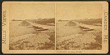
.jpg) Centennial celebration in 1902 | |
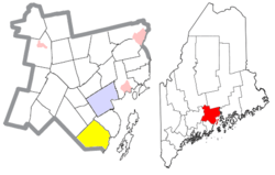 Location of Lincolnville (in yellow) in Waldo County and the state of Maine | |
| Coordinates: 44°17′41″N 69°4′47″W | |
| Country | United States |
| State | Maine |
| County | Waldo |
| Incorporated | 1802 |
| Government | |
| • Board of selectmen | Ladleah Dunn, Chair Keryn Laite, Jr. David Barrows Joshua Gerritsen Jon Fishman[1] |
| • Town Administrator | David B. Kinney[2] |
| Area | |
| • Total | 43.65 sq mi (113.05 km2) |
| • Land | 37.34 sq mi (96.71 km2) |
| • Water | 6.31 sq mi (16.34 km2) |
| Elevation | 230 ft (70 m) |
| Population | |
| • Total | 2,164 |
| • Estimate (2012[5]) | 2,170 |
| • Density | 58.0/sq mi (22.4/km2) |
| Time zone | UTC-5 (Eastern (EST)) |
| • Summer (DST) | UTC-4 (EDT) |
| ZIP code | 04849 |
| Area code(s) | 207 |
| FIPS code | 23-39755 |
| GNIS feature ID | 0582561 |
| Website | town.lincolnville.me.us |
History
Approximately 10,000 years ago, a glacier covered the area to a depth of several thousand feet, carving irregular landforms that survive today. The earliest artifact of European origin was fragments of a 1650-1660 clay pipe, probably a trade good with the native population. First settled in 1774, the town was incorporated in 1802 from Canaan and Ducktrap plantations. It was named for General Benjamin Lincoln, a Revolutionary War General and friend of Henry Knox.[6]
The first school in Lincolnville was a three-sided log cabin with a perpendicular ledge for a fourth wall behind Nathan Knight's home; the ledge served to support a blackboard.
Over the years, the population continued to grow until it was incorporated in 1802. A bicentennial celebration was celebrated by the town in 2002.[7]
Geography
According to the United States Census Bureau, the town has a total area of 43.65 square miles (113.05 km2), of which, 37.34 square miles (96.71 km2) is land and 6.31 square miles (16.34 km2) is water.[3] Located along the western side of Penobscot Bay, Lincolnville is drained by the Ducktrap River. Principle bodies of water include: Megunticook Lake, Norton Pond (123 acres), Coleman Pond (225 acres), Moody Pond (61 acres) and Levenseller Pond (34 acres).
The town is served by U.S. Route 1, Maine State Routes 173, 52 and 235. It is bordered by Belmont on the north, Northport on the northeast, Penobscot Bay on the east, Camden on the south, Hope on the west and Searsmont on the northwest.
Demographics
| Historical population | |||
|---|---|---|---|
| Census | Pop. | %± | |
| 1810 | 1,013 | — | |
| 1820 | 1,294 | 27.7% | |
| 1830 | 1,702 | 31.5% | |
| 1840 | 2,048 | 20.3% | |
| 1850 | 2,174 | 6.2% | |
| 1860 | 2,075 | −4.6% | |
| 1870 | 1,900 | −8.4% | |
| 1880 | 1,705 | −10.3% | |
| 1890 | 1,361 | −20.2% | |
| 1900 | 1,223 | −10.1% | |
| 1910 | 1,020 | −16.6% | |
| 1920 | 811 | −20.5% | |
| 1930 | 818 | 0.9% | |
| 1940 | 892 | 9.0% | |
| 1950 | 881 | −1.2% | |
| 1960 | 867 | −1.6% | |
| 1970 | 955 | 10.1% | |
| 1980 | 1,414 | 48.1% | |
| 1990 | 1,809 | 27.9% | |
| 2000 | 2,042 | 12.9% | |
| 2010 | 2,164 | 6.0% | |
| Est. 2014 | 2,203 | [8] | 1.8% |
| U.S. Decennial Census[9] | |||
2010 census
As of the census[4] of 2010, there were 2,164 people, 959 households, and 635 families living in the town. The population density was 58.0 inhabitants per square mile (22.4/km2). There were 1,465 housing units at an average density of 39.2 per square mile (15.1/km2). The racial makeup of the town was 97.9% White, 0.3% African American, 0.3% Native American, 0.4% Asian, 0.1% Pacific Islander, and 0.9% from two or more races. Hispanic or Latino of any race were 0.8% of the population.
There were 959 households of which 25.4% had children under the age of 18 living with them, 55.1% were married couples living together, 6.9% had a female householder with no husband present, 4.3% had a male householder with no wife present, and 33.8% were non-families. 26.1% of all households were made up of individuals and 10.1% had someone living alone who was 65 years of age or older. The average household size was 2.26 and the average family size was 2.70.
The median age in the town was 47.5 years. 19.7% of residents were under the age of 18; 5.2% were between the ages of 18 and 24; 21.5% were from 25 to 44; 35.8% were from 45 to 64; and 17.7% were 65 years of age or older. The gender makeup of the town was 50.8% male and 49.2% female.
2000 census
As of the census[10] of 2000, there were 2,042 people, 846 households, and 605 families living in the town. The population density was 54.6 people per square mile (21.1/km²). There were 1,272 housing units at an average density of 34.0 per square mile (13.1/km²). The racial makeup of the town was 98.78% White, 0.05% African American, 0.15% Native American, 0.20% Asian, 0.05% Pacific Islander, 0.39% from other races, and 0.39% from two or more races. Hispanic or Latino of any race were 0.83% of the population.
There were 846 households out of which 31.7% had children under the age of 18 living with them, 61.7% were married couples living together, 6.5% had a female householder with no husband present, and 28.4% were non-families. 22.9% of all households were made up of individuals and 9.5% had someone living alone who was 65 years of age or older. The average household size was 2.41 and the average family size was 2.82.
In the town, the population was spread out with 23.1% under the age of 18, 4.9% from 18 to 24, 28.2% from 25 to 44, 29.8% from 45 to 64, and 14.0% who were 65 years of age or older. The median age was 42 years. For every 100 females, there were 99.8 males. For every 100 females age 18 and over, there were 98.0 males.
The median income for a household in the town was $42,273, and the median income for a family was $48,500. Males had a median income of $32,006 versus $28,077 for females. The per capita income for the town was $21,621. About 7.0% of families and 9.1% of the population were below the poverty line, including 9.8% of those under age 18 and 9.5% of those age 65 or over.
Education
Lincolnville is part of School Union 69 (with the Towns of Hope and Appleton), which operates the Lincolnville Central School (LCS), for grades K-8 and is part of the Five Town Consolidated School District (with the Towns of Hope, Appleton, Rockport and Camden), which operates Camden Hills Regional High School. Dianne Helprin is the Superintendent of School Union 69[11] and Maria Libby is the Superintendent of the Five Town CSD.[12]
Notable people

- John Burstein, actor, creator and performer of Slim Goodbody
- Tim Boetsch, mixed martial artist
- Jon Fishman, drummer, Phish[13]
- Elizabeth Hand, author
- Alex Katz, artist
- Eli Pariser, political activist
- Levi Rackliffe, California state treasurer
- Susan Rice, former National Security Advisor and United States Ambassador to the United Nations[14]
- Bidu Sayão, opera soprano
- Neil Welliver, artist
References
- "Board of Selectmen". Town of Lincolnville, Maine. Retrieved March 22, 2018.
- "Town Administrator". Town of Lincolnville, Maine. Retrieved March 22, 2018.
- "US Gazetteer files 2010". United States Census Bureau. Retrieved 2012-12-16.
- "U.S. Census website". United States Census Bureau. Retrieved 2012-12-16.
- "Population Estimates". United States Census Bureau. Archived from the original on 2013-06-11. Retrieved 2013-07-06.
- Coolidge, Austin J.; John B. Mansfield (1859). A History and Description of New England. Boston, Massachusetts: A.J. Coolidge. p. 195.
coolidge mansfield history description new england 1859.
- Comprehensive Plan Review Committee (March 2006). "TOWN OF LINCOLNVILLE, MAINE Comprehensive Plan" (PDF). Main Farmland Trust. Retrieved January 23, 2018.
- "Annual Estimates of the Resident Population for Incorporated Places: April 1, 2010 to July 1, 2014". Archived from the original on May 23, 2015. Retrieved June 4, 2015.
- "Census of Population and Housing". Census.gov. Retrieved June 4, 2015.
- "U.S. Census website". United States Census Bureau. Retrieved 2008-01-31.
- "Dianne Helprin". Union #69. Retrieved 4 October 2017.
- "Maria Libby". Five Town CSD. Retrieved 4 October 2017.
- "Phish's New Harmony: How America's Greatest Jam Band Learned to Get Along". rollingstone.com. Retrieved 2016-10-21.
- "Obama's pick for UN ambassador has ties to Maine". The Portsmouth Herald. Associated Press. December 2, 2008. Retrieved October 8, 2018.
External links
- Town of Lincolnville, Maine
- Lincolnville Historical Society
- Lincolnville Business Group
- NOCASOBE North of Camden, South of Belfast
- Maine Genealogy: Lincolnville, Waldo County, Maine
- Maine.gov -- Lincolnville, Maine
Municipalities and communities of Waldo County, Maine, United States | ||
|---|---|---|
| City |  Waldo County map | |
| Towns | ||
| CDPs | ||
| Other villages | ||