Munger
Munger is a twin city and a Municipal Corporation situated in the Indian state of Bihar.[4] It is the administrative headquarters of Munger district and Munger Division. It is the 11th largest city of Bihar by population.[5]
Munger | |
|---|---|
Urban Agglomeration | |
 | |
 Munger Location in Bihar, India  Munger Munger (India)  Munger Munger (Asia) | |
| Coordinates: 25.381°N 86.465°E | |
| Country | |
| State | Bihar |
| District | Munger |
| Founded by | Chandragupta Maurya |
| Government | |
| • Type | Municipal Corporation |
| • Body | Munger Municipal Corporation |
| • Mayor | Ruma Raj |
| • Municipal Commissioner | Srikant Shastri[1] |
| Area | |
| • Total | 18 km2 (7 sq mi) |
| Elevation | 43 m (141 ft) |
| Population (2011)[2] | |
| • Total | 213,101 |
| • Rank | 11th in Bihar |
| • Density | 12,000/km2 (31,000/sq mi) |
| Demonym(s) | Mungeri |
| Language | |
| • Official | Hindi[3] |
| • Additional official | Urdu[3] |
| • Others | English, Angika, Maithili |
| Time zone | UTC+5:30 (IST) |
| PIN | 811201 to 811214 , 813201 |
| Telephone code | +91-6344 |
| Vehicle registration | BR-08 |
| Website | munger |
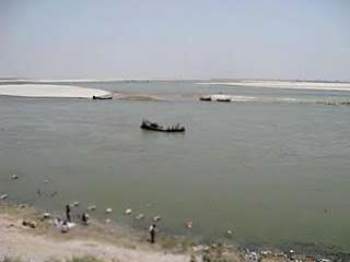
Historically, Munger is known for being an ancient seat of rule. The twin city comprises Munger and Jamalpur situated on the southern bank of the river Ganges.[6] It is situated 60 km west of Bhagalpur, and 180 km east of capital city Patna.
Climate
The climate of Munger is subtropical (warm in summer and cold during winter). The Köppen climate classification sub-type for this climate is humid subtropical.[7]
| Climate data for Munger, India | |||||||||||||
|---|---|---|---|---|---|---|---|---|---|---|---|---|---|
| Month | Jan | Feb | Mar | Apr | May | Jun | Jul | Aug | Sep | Oct | Nov | Dec | Year |
| Average high °C (°F) | 23.5 (74.3) |
26.4 (79.6) |
32.5 (90.5) |
37.0 (98.6) |
37.9 (100.3) |
35.5 (95.9) |
31.9 (89.4) |
31.2 (88.1) |
31.5 (88.7) |
30.8 (87.5) |
27.7 (81.9) |
24.2 (75.6) |
30.8 (87.5) |
| Average low °C (°F) | 9.4 (48.9) |
11.9 (53.4) |
16.9 (62.4) |
21.8 (71.3) |
24.6 (76.3) |
25.4 (77.7) |
24.9 (76.8) |
24.8 (76.6) |
24.2 (75.5) |
20.9 (69.7) |
14.4 (57.9) |
10 (50) |
19.1 (66.4) |
| Average precipitation mm (inches) | 15 (0.6) |
18 (0.7) |
13 (0.5) |
13 (0.5) |
41 (1.6) |
170 (6.8) |
300 (11.7) |
280 (11) |
230 (8.9) |
81 (3.2) |
5.1 (0.2) |
2.5 (0.1) |
1,160 (45.7) |
| Source: weatherbase[7] | |||||||||||||
Demographics
As per 2011 census, Munger Municipal Corporation and Jamalpur Municipal Council has a total population of 213,101 out of which 113,173 were males and 99,928 were females. It had a sex ratio of 883. The population between 0 to 6 years was 29,260. The literacy rate of the 7+ population was 81.83 per cent.[8]
Places of interest
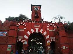
- Munger Fort, covers an area of around 222 acres
- Chandika Asthan, a sacred Shakti-Peeth
- Kastaharni Ghat on the Ganges
- Bhimbandh Wildlife Sanctuary
- Bihar School of Yoga
Transport
Rail
Munger has two railway stations such as: Jamalpur Junction and Munger Railway Station. The former is the main railhead for the city while the later, which was earlier called Purabsarai Railway Station, acts as suburban facility. Stations are connected with Sahibganj Loop.
The rail system provides connection to cities such as New Delhi, Howrah, Lokmanya Tilak Terminus, Surat, Yesvantpur Junction, Jamshedpur, Jammu Tawi, Dibrugarh, Guwahati, Lucknow, Patna, Ranchi, Agartala, Hyderabad, Deoghar Junction, Muzaffarpur Junction and Dhanbad. The Munger Ganga Bridge, which takes both rail and road-traffic, connects Munger to the nearby cities of Begusarai, Saharsa Junction, Katihar and Khagaria Junction as well as various districts of North Bihar.[10] The bridge is the third-largest rail-cum-road bridge in India.[11]
Road
Munger is connected to major parts of India by various National and State Highways. The major cities of Bihar and Jharkhand - such as Patna, Ranchi, Bhagalpur, Purnia, Bihar sharif, Muzaffarpur, Jamshedpur, Dhanbad, Gaya, Bokaro and Darbhanga - can be reached by ![]()
![]()
![]()
The Munger Ganga Bridge is under construction (Road part) and will link Munger to various districts of North Bihar and north-eastern India by 2021.
Air
Munger has a small commercial airport in Safiasarai,Munger which is used by Government for Domestic purpose. Munger has no international airport with commercial service . Domestic airport with commercial service is Jay Prakash Narayan Airport in Patna around 180 km away. Patna is served by all major airlines. Nearest international airport is Netaji Subhash Chandra Bose International Airport in Kolkata Which is around 480 km away from Munger.
Economy
Munger has the second highest per capita income in Bihar after Patna.The per capita income of Munger is more than 3times that of Sheohar , the poorest district of Bihar
Industry
Indian Railways operates of Asia's largest and oldest railway workshops at Jamalpur. This was set up by the British Raj in 1862.[12]
Munger has also ITC Factory established by British, ITC's packaging & printing business at Munger was set up in 1925 as a strategic backward integration for ITC's cigarettes business.It is today India's most sophisticated packaging house. Ordinance Gun Factory Munger , ITC Milk Dairy and many others. Munger has the second highest per capita income in Bihar after Patna.
Institutes
- Bihar School of Yoga is one of the notable organizations in the field of Yoga established in 1964 by Satyananda Saraswati.
- Munger University
Notable people
- Niranjanananda Saraswati, yoga Guru
- Satyananda Saraswati, founder of Bihar School of Yoga
- Nandalal Bose, sculptor and painter
- George Browne, 6th Marquess of Sligo (1856–1935), Anglo-Irish aristocrat, born in Munger
- Krishna Singh, first Chief Minister of Bihar and a freedom fighter
- Kumar Suresh Singh, Director-General of Anthropological Survey of India[13]
- Ramdhari Singh Dinkar, poet
- Raja Udit Narayan Singh of Shakarpura Raj Zamindari- local benefactor
- Mona Das - Washington State Senate
- Wali Rahmani - General Secretary of All India Muslim Personal Law Board of India
- Brahmanand Mandal - Former MP from [[Munger (Lok Sabha constituency)|Munger Lok Sabha constituency]
- Balmiki Prasad Singh(born as Balmiki Prasad Baranwal) - Rai Bahaduree
Educational institutions
- Munger University
- Indian Railway Institute of Mechanical and Electrical Engineering
- Biswanath Singh Institute of Legal Studies
References
- "बिहार में चार IAS अफसरों का तबादला, श्रीकांत शास्त्री बने मुंगेर नगर निगम आयुक्त". Dainik Jagran (in Hindi). 9 March 2019. Retrieved 16 August 2019.
- "Census of India Search details". censusindia.gov.in. Archived from the original on 18 May 2015. Retrieved 10 May 2015.
- "52nd REPORT OF THE COMMISSIONER FOR LINGUISTIC MINORITIES IN INDIA" (PDF). nclm.nic.in. Ministry of Minority Affairs. Archived from the original (PDF) on 25 May 2017. Retrieved 3 January 2019.
- "CDP Munger" (PDF). Urban department, Government of Bihar. Archived (PDF) from the original on 3 March 2016. Retrieved 31 December 2017.
- "Urban Agglomerations/Cities having population 1 lakh and above" (PDF). Provisional Population Totals, Census of India 2011. Retrieved 29 July 2019.
- "CDP Jamalpur" (PDF). Urban Department, Government of Bihar. Archived (PDF) from the original on 9 May 2016. Retrieved 31 December 2017.
- "weatherbase.com". weatherbase. 2014. Archived from the original on 12 July 2017. Retrieved 31 December 2017. Retrieved on 8 April 2014.
- "Cities having population 1 lakh and above" (PDF). Provisional Population Totals, Census of India 2011. Archived (PDF) from the original on 7 May 2012. Retrieved 31 December 2017.
- "Census of india:Socio-cultural aspects". Government of India, Ministry of Home Affairs. Retrieved 9 March 2014.
- Kumod Verma (15 April 2013). "Munger bridge likely to be operational by 2014 year end". The Times of India. TNN. Archived from the original on 8 December 2014. Retrieved 31 December 2017.
- "Top ten rail road bridges in india". Walk Through India. Archived from the original on 13 April 2014. Retrieved 31 December 2017.
- Kumod Verma (28 November 2013). "Minister releases stamp on Jamalpur railway workshop". Times of India. TNN. Archived from the original on 3 July 2017. Retrieved 31 December 2017.
- Rajalakshmi, T. K. (30 June 2006). "Scholar of society". Frontline. 23 (12). Archived from the original on 11 June 2011.