Mong Khet Township
Mong Khet Township[3] (also Mongkhat Township) is a township of Kengtong District in the Shan State of Burma. The principal town and administrative center is Mong Khet.
Mong Khet Township မိုင်းခတ်မြို့နယ် | |
|---|---|
Township | |
 | |
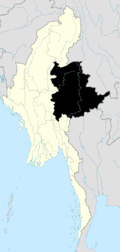
 Mong Khet Township Location in Burma | |
| Coordinates: 21°42′00″N 99°23′00″E | |
| Country | |
| State | Shan State |
| District | Kengtong District |
| Area | |
| • Total | 2,513 km2 (970 sq mi) |
| Elevation | 1,022 m (3,353 ft) |
| Population (2014)[2] | |
| • Total | 44,528 |
| • Density | 17.718/km2 (45.89/sq mi) |
| Time zone | UTC+6.30 (MST) |
Communities
Among the many small towns and villages, in addition to the town of Mong Khet, the following communities are local centers: Wan Namtawnkang, Wan La, Wan Singpyin, Wan Hsi-hsaw, Wan Pang-yao, Wan Ho-hkü, Wan Kawnhawng, Wan Ho-nawng, and Ta-pom.
References
- GoogleEarth
- Myanmar City Population
- Township 220 on "Myanmar States/Divisions & Townships Overview Map" Myanmar Information Management Unit (MIMU), December 2007
External links
- "Mongkhak Google Satellite Map" Maplandia World Gazetteer
Capital: Mong Khet | |
|

This article is issued from Wikipedia. The text is licensed under Creative Commons - Attribution - Sharealike. Additional terms may apply for the media files.