Millville, Ohio
Millville is a village in Butler County, Ohio, United States. The population was 708 at the 2010 census.
Millville, Ohio | |
|---|---|
 Liberty Street | |
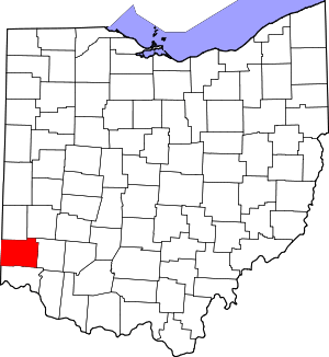
 Location of Millville, Ohio | |
 Location of Millville in Butler County | |
| Coordinates: 39°23′22″N 84°39′16″W | |
| Country | United States |
| State | Ohio |
| County | Butler |
| Government | |
| • Mayor | Robert P. Settles[1] |
| Area | |
| • Total | 0.58 sq mi (1.50 km2) |
| • Land | 0.58 sq mi (1.50 km2) |
| • Water | 0 sq mi (0 km2) |
| Elevation | 620 ft (189 m) |
| Population | |
| • Total | 708 |
| • Estimate (2019[5]) | 733 |
| • Density | 1,220.7/sq mi (471.3/km2) |
| Time zone | UTC-5 (Eastern (EST)) |
| • Summer (DST) | UTC-4 (EDT) |
| ZIP code | 45013 |
| Area code(s) | 513 |
| FIPS code | 39-50540[6] |
| GNIS feature ID | 1061526[3] |
History
The village was established in 1815 by Joseph Van Horn, who opened a grist mill there about 1805.[7] Baseball's first commissioner Kenesaw Mountain Landis was born in Millville.
Geography
Millville is located at 39°23′22″N 84°39′16″W (39.389327, -84.654500).[8]
According to the United States Census Bureau, the village has a total area of 0.58 square miles (1.50 km2), all land.[2]
Demographics
| Historical population | |||
|---|---|---|---|
| Census | Pop. | %± | |
| 1880 | 250 | — | |
| 1930 | 301 | — | |
| 1940 | 335 | 11.3% | |
| 1950 | 458 | 36.7% | |
| 1960 | 676 | 47.6% | |
| 1970 | 697 | 3.1% | |
| 1980 | 809 | 16.1% | |
| 1990 | 755 | −6.7% | |
| 2000 | 817 | 8.2% | |
| 2010 | 708 | −13.3% | |
| Est. 2019 | 733 | [5] | 3.5% |
| U.S. Decennial Census[9] | |||
2010 census
As of the census[4] of 2010, there were 708 people, 269 households, and 197 families living in the village. The population density was 1,220.7 inhabitants per square mile (471.3/km2). There were 298 housing units at an average density of 513.8 per square mile (198.4/km2). The racial makeup of the village was 97.5% White, 0.1% African American, 0.1% Native American, 0.8% Asian, 0.4% from other races, and 1.0% from two or more races. Hispanic or Latino of any race were 0.3% of the population.
There were 269 households of which 36.4% had children under the age of 18 living with them, 53.2% were married couples living together, 13.4% had a female householder with no husband present, 6.7% had a male householder with no wife present, and 26.8% were non-families. 23.0% of all households were made up of individuals and 10.7% had someone living alone who was 65 years of age or older. The average household size was 2.63 and the average family size was 3.03.
The median age in the village was 38.9 years. 23% of residents were under the age of 18; 11.4% were between the ages of 18 and 24; 24.3% were from 25 to 44; 27.4% were from 45 to 64; and 14% were 65 years of age or older. The gender makeup of the village was 48.2% male and 51.8% female.
2000 census
As of the census[6] of 2000, there were 817 people, 312 households, and 247 families living in the village. The population density was 1,382.8 people per square mile (534.7/km²). There were 330 housing units at an average density of 558.6 per square mile (216.0/km²). The racial makeup of the village was 98.29% White, 0.61% African American, 0.12% Native American, 0.12% Asian, 0.37% from other races, and 0.49% from two or more races.
There were 312 households out of which 35.6% had children under the age of 18 living with them, 59.6% were married couples living together, 15.1% had a female householder with no husband present, and 20.8% were non-families. 17.6% of all households were made up of individuals and 6.7% had someone living alone who was 65 years of age or older. The average household size was 2.62 and the average family size was 2.93.
In the village, the population was spread out with 25.6% under the age of 18, 6.7% from 18 to 24, 30.5% from 25 to 44, 25.8% from 45 to 64, and 11.4% who were 65 years of age or older. The median age was 37 years. For every 100 females there were 87.8 males. For every 100 females age 18 and over, there were 89.4 males.
The median income for a household in the village was $45,341, and the median income for a family was $45,972. Males had a median income of $39,306 versus $25,208 for females. The per capita income for the village was $18,835. About 6.5% of families and 7.0% of the population were below the poverty line, including 9.9% of those under age 18 and 11.0% of those age 65 or over.
History
Approximately 5.5 miles to the north is the historic Presbyterian cemetery that includes graves of early pioneers including some who served in the revolutionary war. There are many graves of families Ross, the name of nearby town Ross, Ohio.
References
- "City & Village Information". Butler County Engineer's Office. Retrieved 3 June 2018.
- "US Gazetteer files 2010". United States Census Bureau. Archived from the original on 2012-01-25. Retrieved 2013-01-06.
- "US Board on Geographic Names". United States Geological Survey. 2007-10-25. Retrieved 2008-01-31.
- "U.S. Census website". United States Census Bureau. Retrieved 2013-01-06.
- "Population and Housing Unit Estimates". Retrieved May 21, 2020.
- "U.S. Census website". United States Census Bureau. Retrieved 2008-01-31.
- Bartlow, Bert Surene (1905). Centennial History of Butler County, Ohio. B. F. Bowen. p. 346.
- "US Gazetteer files: 2010, 2000, and 1990". United States Census Bureau. 2011-02-12. Retrieved 2011-04-23.
- "Census of Population and Housing". Census.gov. Retrieved June 4, 2015.
Further reading
- Bert S. Barlow, W.H. Todhunter, Stephen D. Cone, Joseph J. Pater, and Frederick Schneider, eds. Centennial History of Butler County, Ohio. Hamilton, Ohio: B.F. Bowen, 1905.
- Jim Blount. The 1900s: 100 Years In the History of Butler County, Ohio. Hamilton, Ohio: Past Present Press, 2000.
- Butler County Engineer's Office. Butler County Official Transportation Map, 2003. Fairfield Township, Butler County, Ohio: The Office, 2003.
- A History and Biographical Cyclopaedia of Butler County, Ohio with Illustrations and Sketches of Its Representative Men and Pioneers. Cincinnati, Ohio: Western Biographical Publishing Company, 1882.
- Ohio. Secretary of State. The Ohio municipal and township roster, 2002-2003. Columbus, Ohio: The Secretary, 2003.
Municipalities and communities of Butler County, Ohio, United States | ||
|---|---|---|
| Cities |
|  Map of Ohio highlighting Butler County |
| Villages | ||
| Townships | ||
| CDPs | ||
| Unincorporated communities | ||
| Footnotes | ‡This populated place also has portions in an adjacent county or counties | |