Mezynskyi National Nature Park
Mezynskyi National Nature Park (Ukrainian: Мезинський національний природний парк) is a national park of Ukraine that covers forest and floodplain terraces of the Desna River in the northern part of the country. The park was created to balance the protection of sensitive ecological and archaeological sites, recreation, and rural agriculture. Administratively, the park is in the Korop District of Chernihiv Oblast, about 50 km south of the regional city of Kharkiv.[1]
| Mezynskyi National Nature Park | |
|---|---|
| Ukrainian: Мезинський національний природний парк | |
IUCN category II (national park) | |
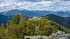
 Mezynskyi National Nature Park | |
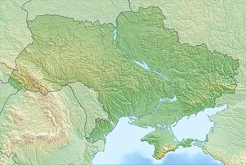 Location of Park | |
| Location | Chernihiv Oblast |
| Coordinates | 51°43′09″N 32°17′12″E |
| Area | 31,035 hectares (76,689 acres; 310 km2; 120 sq mi) |
| Established | 2004 |
| Governing body | Ministry of Ecology and Natural Resources (Ukraine) |
| Website | http://mezinpark.com.ua/ |
Topography
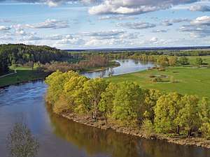
Most of the park is on the right bank of the Desna River, which runs north to south down the eastern and southern borders of the park.[1] The terrain is glacial morraines, sloping terraces, floodplain terraces, and elevated plains with many tributary streams running down to the river. The hills range from 125 to 208 meters above sea level. The general area is part of the Dnieper River Lowlands. The park is about 20 km west-to-east, and 30 km north-to-south. It is situated about 110 km east of the regional city of Chernihiv, and 60 km downstream from the border with Russia to the north.[1]
Climate and ecoregion
The climate of Mezynskyi NP is Humid continental climate, warm summer (Köppen climate classification (Dfb)). This climate is characterized by large seasonal temperature differentials and a warm summer (at least four months averaging over 10 °C (50 °F), but no month averaging over 22 °C (72 °F).[2][3] Precipitation in the Mezynskyi general region averages 590–640 mm/yr. The average temperature in January is −7.9 °C (17.8 °F), and in August is 19.4 °C (66.9 °F). There is snow cover for 110–115 days on average, with depth averaging 21–22 cm.[1]
Mezynskyi is located in the East European forest steppe ecoregion, a transition zone between the broadleaf forests of the north and the grasslands to the south.. This ecoregion is characterized by a mosaic of forests, steppe, and riverine wetlands.[4]
Flora and fauna
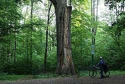
Forest covers 38% of the park, steppe and grasslands cover 16%, rural agriculture covers 35% (with several small villages in the park), 3% is lakes, 1% is bog-land, and 7% is of other cover.[1] The forest types are Lime-oak and maple-lime-oak. There are 625 species of higher plants that have been recorded in the park. 224 species of birds, and 48 species of mammals have been recorded.
Public use
The park features three museums, which can be visited for a small fee:
- Mezinsky Archeological Research Museum
- Visitor Center and Museum of Mezynskyi National Park
- The Center for Preserving Antiquities, a room of ethnography and history of Mezynskyi
There are a number of hiking trails and campsites. Visitors can stay in fixed lodging on site, parking is available. Campers can rent tents, sleeping bags, coats, and backpacks.[5]
See also
References
- "Mezynskyi National Nature Park" (in Ukrainian). Official Park Site. Retrieved June 12, 2019.
- Kottek, M., J. Grieser, C. Beck, B. Rudolf, and F. Rubel, 2006. "World Map of Koppen-Geiger Climate Classification Updated" (PDF). Gebrüder Borntraeger 2006. Retrieved September 14, 2019.CS1 maint: multiple names: authors list (link)
- "Dataset - Koppen climate classifications". World Bank. Retrieved September 14, 2019.
- "Map of Ecoregions 2017". Resolve, using WWF data. Retrieved September 14, 2019.
- "Schedule of fees, Official Park Website". Mezynskyi National Park. Retrieved June 13, 2019.
External links
| Wikimedia Commons has media related to Mezynskyi National Nature Park. |