Cheremske Nature Reserve
Cheremske Nature Reserve (Ukrainian: Черемський заповідник) is a protected nature reserve of Ukraine that covers forest and wetlands of the Western Polesia region, in the northwest of the country. The area is one of high biodiversity because of the varied habitat in transitional ecological zones. The reserve is in the administrative district of Manevychi in Volyn Oblast[1][2]
| Cheremske Nature Reserve | |
|---|---|
| Ukrainian: Черемський заповідник | |
IUCN category Ia (strict nature reserve) | |
 Cheremske Nature Reserve | |
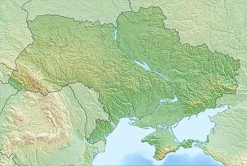 Location of Reserve | |
| Location | Volyn Oblast, Manevychi Raion |
| Nearest city | Lutsk |
| Coordinates | 51°22′25″N 25°28′40″E |
| Area | 2,976 hectares (7,354 acres; 30 km2; 11 sq mi) |
| Established | 2001 |
| Governing body | State Forestry Committee of Ukraine |
Topography
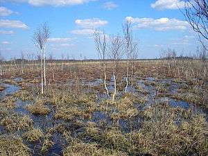
The terrain is flat and boggy, with fluvial deposits of the Ice Age. In places the peat is 10 meters thick.[2]

Climate and ecoregion
The climate of Cheremske is Humid continental climate, warm summer (Köppen climate classification (Dfb)). This climate is characterized by large seasonal temperature differentials and a warm summer (at least four months averaging over 10 °C (50 °F), but no month averaging over 22 °C (72 °F).[3][4]
The reserve is located in the Central European mixed forests ecoregion, a temperate hardwood forest covering much of northeastern Europe, from Germany to Russia.[5]
Flora and fauna
The reserve is approximately 65% forested and 35% wetlands.[1] The Cherem transitional sedge-sphagnum bogs is one of the largest and best preserved in Ukraine.[2]
Public use
As a strict nature reserve, Chermeske's primary purpose is protection of nature and scientific study. Public access is limited: mass recreation and construction of facilities is prohibited as are hunting and fishing. There are several "ecological" educational trails for supervised public use.[1]
See also
- Lists of Nature Preserves of Ukraine (class Ia protected areas)
- National Parks of Ukraine (class II protected areas)
References
- "Cheremske Nature Reserve" (in Ukrainian). Volyn Oblast. Retrieved August 17, 2019.
- "Cheremske Nature Reserve" (in Ukrainian). Ukraine Incognita. Retrieved August 17, 2019.
- Kottek, M., J. Grieser, C. Beck, B. Rudolf, and F. Rubel, 2006. "World Map of Koppen-Geiger Climate Classification Updated" (PDF). Gebrüder Borntraeger 2006. Retrieved September 14, 2019.CS1 maint: multiple names: authors list (link)
- "Dataset - Koppen climate classifications". World Bank. Retrieved September 14, 2019.
- "Map of Ecoregions 2017". Resolve, using WWF data. Retrieved September 14, 2019.
External links
| Wikimedia Commons has media related to Cheremskyi Nature Reserve. |