Meteorological history of Hurricane Katrina
Hurricane Katrina was an extremely destructive Category 5 hurricane that affected the majority of the Gulf Coast. Its damaging trek began on August 23, 2005, when it originated as Tropical Depression Twelve near the Bahamas. The next day, the tropical depression strengthened to a tropical storm, and was named Katrina; it proceeded to make landfall on the southern tip of the U.S. state of Florida as a minimal hurricane.
| Category 5 major hurricane (SSHWS/NWS) | |
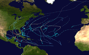
 Track of Hurricane Katrina | |
| Formed | August 23, 2005 |
|---|---|
| Dissipated | August 31, 2005[1] |
| (Extratropical after August 30) | |
| Highest winds | 1-minute sustained: 175 mph (280 km/h) |
| Lowest pressure | 902 mbar (hPa); 26.64 inHg |
| Areas affected | Bahamas, South Florida, Cuba, Louisiana (especially Greater New Orleans), Mississippi, Alabama, Florida Panhandle, most of eastern North America |
| Part of the 2005 Atlantic hurricane season | |
In passing across Florida, Katrina did not attain any more strength but did manage to maintain hurricane status. After passing over Florida, the warm waters of the Gulf of Mexico allowed it to rapidly intensify to the sixth-strongest Atlantic hurricane in recorded history. Afterward, Katrina made landfall as a Category 3 storm near Buras-Triumph, Louisiana, and once more near the Mississippi/Louisiana border. Katrina progressed northward through the central United States and finally dissipated near the Great Lakes on August 31, when it was absorbed by a cold front.
Formation
On August 19, a tropical wave merged with the remnants of Tropical Depression Ten, the surface low of which had dissipated earlier due to the effects of a nearby upper tropospheric trough. On August 23, 2005, at 5:00 p.m. EDT (2100 UTC), this system developed into Tropical Depression Twelve over the southeastern Bahamas.[1] While the normal standards for numbering tropical depressions in the Atlantic indicate that the old name/number is retained when a depression dissipates and regenerates, satellite data indicated that a second tropical wave combined with Tropical Depression Ten north of Puerto Rico to form a new, much more advanced system, which was then designated as Tropical Depression Twelve.[2] Simultaneously, the trough in the upper storm weakened, causing the wind shear in the area to relax, thereby allowing the new tropical depression to develop. In a later re-analysis, it was determined that the low-level circulation of Ten had completely detached and dissipated, with only the remnant mid-level circulation moving on and merging with the aforementioned second tropical wave. As a result, the criteria for keeping the same name and identity were not met.[1]
First landfall

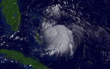
As the atmospheric conditions surrounding Tropical Depression Twelve were favorable for tropical development, the system began to intensify and was upgraded to Tropical Storm Katrina on the morning of August 24. A burst of convection allowed Katrina to become the fifth hurricane of the 2005 season on August 25, only two hours before it made landfall around 6:30 p.m. EST (2230 UTC) between Hallandale Beach and Aventura, Florida. Katrina struck the peninsula with 80-mile-per-hour (130-kilometre-per-hour) winds, and had a well-defined eye on NEXRAD weather radar, which remained intact throughout its passage over Florida. Parts of the Florida Keys experienced tropical storm winds throughout August 26, with the Dry Tortugas briefly experiencing hurricane-force winds.[1]
Gulf of Mexico
The initial National Hurricane Center forecasts predicted that Katrina would begin turning northward after landfall, eventually to hit the Florida Panhandle approximately three to four days later.[3] Katrina, however, continued a westerly and west-southwesterly track, which eventually shifted the forecast track westward to New Orleans.[4]

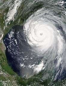
Immediately after the storm entered the Gulf of Mexico, the low wind shear, good upper-level outflow, and the warm sea surface temperatures of the Gulf Loop Current caused Katrina to intensify rapidly. On August 27, the storm was upgraded to Category 3 intensity,[5] becoming the third major hurricane of the season. An eyewall replacement cycle disrupted the intensification of maximum winds for about 18 hours, but almost doubled the radius of the storm.[1] A second period of rapid intensification started by 7:00 p.m. CDT on August 27, and by 12:40 a.m. CDT on August 28, Katrina was upgraded to a Category 4 hurricane with maximum sustained winds of 145 mph (233 km/h).[6] It became a Category 5 (the first in the Gulf of Mexico since Hurricane Allen 25 years prior) storm by 7:00 a.m. CDT,[7] twelve hours after the beginning of the second round of rapid intensification, and reached its peak intensity at 1:00 p.m. CDT with maximum sustained winds of 175 mph (282 km/h), gusts of 215 mph (346 km/h) and a central pressure of 902 millibars.[8] The minimum pressure made Katrina, at the time, the fourth-most intense Atlantic hurricane on record (Hurricanes Rita and Wilma would later surpass Katrina that same year).[1] As the hurricane approached New Orleans, the Weather Forecast Office in Slidell, Louisiana issued two strongly worded warnings of the storm's danger.
By the afternoon of August 28, the storm was large enough that some areas of the Gulf Coast were already experiencing tropical storm-force winds. The center of Katrina was about 180 statute miles (290 km) from the mouth of the Mississippi River, but tropical storm-force winds extended 230 miles (370 km) from the center of the storm, and hurricane-force winds extended about 105 miles (170 km) away.[9] Overnight on August 29, and into the morning of the next day, Katrina quickly weakened (in terms of maximum sustained winds) as it began to enter another eyewall replacement cycle. The inner eyewall deteriorated before an outer eyewall had fully formed, playing an important role in the weakening. In 18 hours, the hurricane's maximum sustained winds decreased from 170 mph (270 km/h) to 125 mph (201 km/h).[1] However, storm surge remained high at landfall because large waves greater than 30 feet (9.1 metres) in height were generated beforehand (with a buoy recording a 55-foot (17-metre) wave at sea), when Katrina was at Categories 4 and 5 on the Saffir–Simpson hurricane scale. The waves then combined with the storm surge of the large Category 3 hurricane.[1]
Second and third landfalls
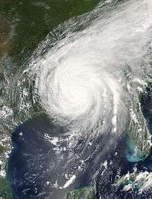
Katrina made its second landfall at 6:10 a.m. CDT on August 29 as a Category 3 hurricane with sustained winds of 125 miles per hour (201 km/h) near Buras-Triumph, Louisiana. Because Katrina had just weakened from Category 4 and due to the shape of the coastline, sustained Category 4 winds likely existed on land while the eye was over water. At landfall, hurricane-force winds extended 120 miles (190 kilometres) from the center, the storm's pressure was 920 millibars (27 inches of mercury), and its forward speed was 15 mph (24 km/h). As it made its way up the eastern Louisiana coastline, most communities in Plaquemines, St. Bernard Parish, and Slidell in St. Tammany Parish were severely damaged by storm surge and the strong winds of the eyewall, which also grazed eastern New Orleans, causing in excess of $1 billion worth of damage to the city (see Effect of Hurricane Katrina on New Orleans).
Original estimates indicated that Katrina had made this landfall as a Category 4 hurricane, with 135-mile-per-hour (217-kilometre-per-hour) winds;[10] however, as indicated above, the storm weakened just before landfall to Category 3 intensity. The reasons for this weakening are not completely known yet; while the eye-wall replacement cycle played a part, slightly increasing shear, dropping sea-surface temperatures, dry air on the western semicircle of the storm, and interaction with the continental landmass also may have played a role in weakening the cyclone.[1] This follows the trend of previous strong cyclones in the Gulf of Mexico: most cyclones with minimum central pressures of 973 millibars (28.7 inHg) or less have weakened over the 12 hours before making landfall in the Gulf Coast of the United States.[1]

A few hours later, after weakening slightly, Katrina made its third landfall near the Louisiana–Mississippi border with 125-mile-per-hour (201-kilometre-per-hour) sustained winds and 928-millibar (27.4 inHg) pressure, still at Category 3 intensity. Its minimum pressure at its second landfall was 920 mbar (27 inHg), making Katrina the fourth-strongest hurricane on record to make landfall on the United States, behind Hurricane Michael's 919-millibar (27.138 inHg) reading, Hurricane Camille's 900-millibar (27 inHg) reading in 1969, and the 1935 Labor Day Hurricane's 892-millibar (26.3 inHg) record.[1]
Because the storm was so large, highly destructive eye-wall winds and the strong northeastern quadrant of the storm pushed record storm surges onshore, smashing the entire Mississippi Gulf Coast, including towns in Mississippi such as Waveland, Bay St. Louis, Pass Christian, Long Beach, Gulfport, Biloxi, Ocean Springs, Gautier and Pascagoula, and, in Alabama, Bayou La Batre. The surges peaked at 28 feet (8.5 m) in Bay St. Louis, Mississippi, and at 13 ft (4.0 m) as far away as Mobile, Alabama, which saw its highest storm surge since 1917.[1] Storm surge was particularly high due to the hydrology of the region, the hurricane's extreme size, and the fact that it weakened only shortly before landfall. As Katrina moved inland diagonally over Mississippi, high winds cut a swath of damage that affected almost the entire state.[1]
Demise
Katrina maintained hurricane strength well into Mississippi, but weakened thereafter, losing hurricane strength more than 150 miles (240 km) inland, near Meridian, Mississippi. It was downgraded to a tropical depression near Clarksville, Tennessee and broke in half.[11] One half continued to race northward, affecting the Central United States along its path, and was last distinguishable in the eastern Great Lakes region on August 31. On August 31, Katrina merged with a frontal boundary and became a powerful extratropical low, causing 1.97–6.69 inches (50–170 mm) of rain in 12 hours, as well as gale-force wind gusts from 31 to 61 mph (50 to 98 km/h) in southeastern Quebec and northern New Brunswick. In the region of Saguenay and Côte-Nord, rain caused breakdowns and failure in roads. The Côte-Nord region was isolated from the rest of Quebec for at least 1 week. The other half of Katrina broke off in the eastern part of the Appalachians, primarily leading to a significant tornado outbreak in the area from central Georgia to central Pennsylvania, killing two people and causing millions of dollars in additional damage. [1]
At 11:00 p.m. EDT on August 31, the center of the remnant low of what was Katrina had been completely absorbed by a frontal boundary in southeastern Canada, with no discernible circulation.[12][13]
See also
- Hurricane Katrina tornado outbreak
- Risk prevention
- Timeline of Hurricane Katrina
References
- Knabb, Richard D.; Rhome, Jamie R. "Tropical Cyclone Report: Hurricane Katrina." National Hurricane Center. December 20, 2005.
- Stewart, Stacy (August 23, 2005). "Tropical Depression Twelve, Discussion No. 1, 5:00 p.m. EDT". National Hurricane Center. Retrieved 2006-09-16.
- Stewart, Stacy (August 24, 2005). "Tropical Storm Katrina Discussion No. 5, 5:00 p.m. EDT". National Hurricane Center. Retrieved 2006-09-16.
- Stewart, Stacy (August 26, 2005). "Hurricane Katrina Discussion No. 14, 5:00 p.m. EDT". National Hurricane Center. Retrieved 2006-09-16.
- Knabb, Richard (August 27, 2005). "Hurricane Katrina Advisory No. 16, 5:00 a.m. EDT". National Hurricane Center. Retrieved 2006-09-16.
- Knabb, Richard (August 28, 2005). "Hurricane Katrina Advisory No. 20, 1:00 a.m. CDT". National Hurricane Center. Retrieved 2006-09-16.
- Knabb, Richard; Richard Pasch (August 28, 2005). "Hurricane Katrina Special Advisory No. 20, 7:00 a.m. CDT". National Hurricane Center. Retrieved 2006-09-16.
- Pasch, Richard (August 28, 2005). "Hurricane Katrina Intermediate Advisory No. 23a, 1:00 p.m. CDT". National Hurricane Center. Retrieved 2006-09-16.
- Pasch, Richard (August 28, 2005). "Hurricane Katrina Advisory No. 24, 4:00 p.m. CDT". National Hurricane Center. Retrieved 2006-09-16.
- Pasch, Richard (August 29, 2005). "Hurricane Katrina Intermediate Advisory No. 26b, 8:00 a.m. CDT". National Hurricane Center. Retrieved 2006-09-16.
- Avila, Lixion (August 30, 2005). "Tropical Depression Katrina Advisory No. 31, 10 a.m. CDT". National Hurricane Center. Retrieved 2006-09-16.
- "Public Advisory 37 for the Remnants of Katrina, 11 p.m. EDT". Hydrometeorological Prediction Center. August 31, 2005. Archived from the original on September 22, 2013. Retrieved September 16, 2006.
- "Post-Tropical Storm Katrina Information Statement, 08:00 a.m. EDT". Canadian Hurricane Centre. August 31, 2005. Archived from the original on 2006-07-16. Retrieved 2006-09-19.