Melinda Airport
Melinda Airport (IATA: MDB, ICAO: MZML) is an airstrip just east of Hope Creek, a village in the Stann Creek District of Belize. The gravel runway is on the south edge of the Melinda Forest Reserve,[3] and just off the Hummingbird Highway.
Melinda Airport | |||||||||||
|---|---|---|---|---|---|---|---|---|---|---|---|
| Summary | |||||||||||
| Airport type | Public | ||||||||||
| Serves | Hope Creek, Belize | ||||||||||
| Elevation AMSL | 101 ft / 31 m | ||||||||||
| Coordinates | 17°00′09″N 88°18′05″W | ||||||||||
| Map | |||||||||||
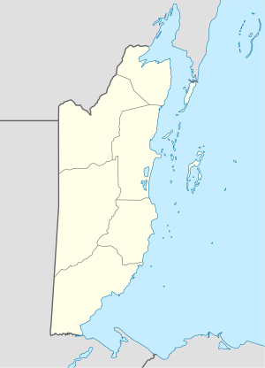 MDB Location of Melinda Airport in Belize | |||||||||||
| Runways | |||||||||||
| |||||||||||
The Belize VOR-DME (Ident: BZE) is located 32.2 nautical miles (60 km) north of the runway.[4]
See also

- Transport in Belize
- List of airports in Belize
References
- "Melinda Airport". HERE Maps. Retrieved 21 January 2019.
- Airport information for Melinda Airport at Great Circle Mapper.
- "Melinda Forest Reserve". HERE Maps. Retrieved 21 January 2019.
- "Belize VOR". Our Airports. Retrieved 17 January 2019.
External links
- OpenStreetMap - Melinda Airport
- OurAirports - Melinda Airport
- Accident history for MDB at Aviation Safety Network
This article is issued from Wikipedia. The text is licensed under Creative Commons - Attribution - Sharealike. Additional terms may apply for the media files.