McNett Township, Lycoming County, Pennsylvania
McNett Township is a township in Lycoming County, Pennsylvania, United States. The population was 211 at the 2000 census. It is part of the Williamsport, Pennsylvania Metropolitan Statistical Area.
McNett Township, Lycoming County, Pennsylvania | |
|---|---|
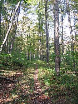 The Old Loggers Path | |
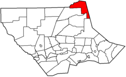 Map of Lycoming County, Pennsylvania highlighting McNett Township | |
 Map of Lycoming County, Pennsylvania | |
| Coordinates: 41°32′22″N 76°49′46″W | |
| Country | United States |
| State | Pennsylvania |
| County | Lycoming |
| Settled | 1805 |
| Incorporated | 1878 |
| Area | |
| • Total | 33.92 sq mi (87.84 km2) |
| • Land | 33.54 sq mi (86.88 km2) |
| • Water | 0.37 sq mi (0.97 km2) |
| Elevation | 1,798 ft (548 m) |
| Population (2010) | |
| • Total | 174 |
| • Estimate (2016)[3] | 168 |
| • Density | 5.01/sq mi (1.93/km2) |
| Time zone | UTC-5 (Eastern (EST)) |
| • Summer (DST) | UTC-4 (EDT) |
| FIPS code | 42-081-46352 |
| GNIS feature ID | 1216759[2] |
History
McNett Township, in the northeastern corner of Lycoming County, was formed by the Pennsylvania General Assembly on January 26, 1878 from McIntyre Township. The formation was a result of a successful petition and election by the citizens of the northeastern corner of Lycoming County who were under the leadership of H. I. McNett, for whom the township was named.[4]
McNett Township has always been a remote portion of Pennsylvania. Farming and industry is at a minimum. Most of the land is mountainous and is covered with a thriving second growth forest. The population which was 619 persons in the 1890 census has fallen to just 211 at the 2000 census.
Geography
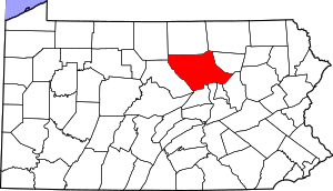
McNett Township is bordered by Tioga County to the north, Bradford and Sullivan Counties to the east, and Cascade and McIntyre Townships to the south and east.[5] As the crow flies, Lycoming County is about 130 miles (209 km) northwest of Philadelphia and 165 miles (266 km) east-northeast of Pittsburgh.
According to the United States Census Bureau, the township has a total area of 33.8 square miles (87.5 km2), all of it land.
Demographics
| Historical population | |||
|---|---|---|---|
| Census | Pop. | %± | |
| 2010 | 174 | — | |
| Est. 2016 | 168 | [3] | −3.4% |
| U.S. Decennial Census[6] | |||
As of the census[7] of 2000, there were 211 people, 81 households, and 57 families residing in the township. The population density was 6.2 people per square mile (2.4/km2). There were 191 housing units at an average density of 5.7/sq mi (2.2/km2). The racial makeup of the township was 94.31% White, 3.79% African American, 0.95% Native American, and 0.95% from two or more races. Hispanic or Latino of any race were 0.47% of the population.
There were 81 households, out of which 21.0% had children under the age of 18 living with them, 53.1% were married couples living together, 11.1% had a female householder with no husband present, and 29.6% were non-families. 27.2% of all households were made up of individuals, and 8.6% had someone living alone who was 65 years of age or older. The average household size was 2.37 and the average family size was 2.75.
In the township the population was spread out, with 16.1% under the age of 18, 5.7% from 18 to 24, 33.2% from 25 to 44, 22.7% from 45 to 64, and 22.3% who were 65 years of age or older. The median age was 43 years. For every 100 females there were 106.9 males. For every 100 females age 18 and over, there were 105.8 males.
The median income for a household in the township was $22,917, and the median income for a family was $23,068. Males had a median income of $24,750 versus $13,750 for females. The per capita income for the township was $10,556. About 24.5% of families and 29.9% of the population were below the poverty line, including 37.0% of those under the age of eighteen and 17.0% of those sixty five or over.
References
- "2016 U.S. Gazetteer Files". United States Census Bureau. Retrieved Aug 14, 2017.
- "US Board on Geographic Names". United States Geological Survey. 2007-10-25. Retrieved 2008-01-31.
- "Population and Housing Unit Estimates". Retrieved June 9, 2017.
- Meginness, John Franklin (1892). "McIntyre and McNett". History of Lycoming County, Pennsylvania: including its aboriginal history; the colonial and revolutionary periods; early settlement and subsequent growth; organization and civil administration; the legal and medical professions; internal improvement; past and present history of Williamsport; manufacturing and lumber interests; religious, educational, and social development; geology and agriculture; military record; sketches of boroughs, townships, and villages; portraits and biographies of pioneers and representative citizens, etc. etc (1st ed.). Chicago: Brown, Runk & Co. ISBN 0-7884-0428-8. Retrieved 2007-02-20.
(Note: ISBN refers to Heritage Books July 1996 reprint. URL is to a scan of the 1892 version with some OCR typos).
- "2007 General Highway Map Lycoming County Pennsylvania" (PDF) (Map). 1:65,000. Pennsylvania Department of Transportation, Bureau of Planning and Research, Geographic Information Division. Retrieved 2009-12-26.
- "Census of Population and Housing". Census.gov. Retrieved June 4, 2016.
- "U.S. Census website". United States Census Bureau. Retrieved 2008-01-31.
Municipalities and communities of Lycoming County, Pennsylvania, United States | ||
|---|---|---|
| City | | |
| Boroughs | ||
| Townships |
| |
| CDPs | ||
| Unincorporated communities | ||
| Ghost town | ||
| Footnotes | ‡This populated place also has portions in an adjacent county | |