Masungi Georeserve
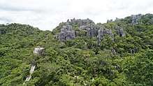
The Masungi Georeserve is a conservation area in the Philippines situated in the Southern Sierra Madre range in Baras, Rizal, 47 kilometres (28 mi) east of Manila. It centers on the geological formations of Masungi Rock, at an elevation of 640 metres (2,100 ft).[1] In 1993, the Masungit Rock and its vicinity was proposed to be declared as a Strict Nature Reserve and Wildlife Sanctuary by the Department of Environment and Natural Resources.[2] It has been a popular destination for hikes and day trips from Manila since it opened in 2015 and started development towards Geopark status.[3]
| Masungi Georeserve | |
|---|---|
 The Sapot web-style view platform at the Masungi Georeserve | |
| Location | Baras, Rizal, Philippines |
| Coordinates | 14°36′18″N 121°20′19″E |
| Established | 1996 |
| Governing body | Masungi Georeserve Foundation |
| www.masungigeoreserve.com | |
Description
The Masungi Georeserve is located at kilometer 47 Kilometer 47, Marcos Highway, Baras, Rizal, Philippines, 1970. The Masungi Georeserve is characterized by rugged limestone karst peaks, steep slopes, and surrounding lush montane rainforests. It contains several caves, including the Yungib ni Ruben (Ruben's Cave), which features stalactite and stalagmite formations, as well as a man-made fountain.[4]
A popular attraction in the park is the Sapot ("Cobweb"), a metallic platform with wooden steps which allows visitors to walk on suspended netting above the karst and get a 360-degree view of the Sierra Madre and the Laguna de Bay.[4] The park's tallest peak, Tatay, also has a viewing deck at its summit. The limestone formations are connected by hanging bridges, rope courses and eco-trails developed by the Masungi Georeserve Foundation and Blue Star Development.[3] On one of the hanging bridges, a wooden cable car-like shelter called Patak ("water droplet") can be found which serves as a rest stop for visitors. The Duyan, a giant rope hammock spanning a few hundred feet, is one of Masungi's most photographed rope courses.[4]
The park was formerly a component of the Mariquina Watershed Reservation from its creation on July 26, 1904 to Oct. 29, 1973.[5] It is home to a variety of fauna including different kinds of birds and insects, cloud rats, monitor lizards, snakes, monkeys and civets.[3]
Trail specifications
The Masungi Georeserve only allows guests to go through the conservation area on a limited number and via trail visit request. An experienced park ranger will be guiding guests all throughout the trek providing an in-depth information about the sustainable tourism in the Philippines.
_at_Masungi_Georeserve.jpg)
References
- "Masungit Rock, Province of Rizal, Calabarzon". Geonamebase.com. Retrieved 10 January 2017.
- "Administrative Order No. 33" (PDF). Department of Environment and Natural Resources. Retrieved 10 January 2017.
- Evangelista, C. (27 November 2016). "Exploring Rizal's Masungi Georeserve". Philippine Daily Inquirer. Retrieved 10 January 2017.
- Reyes, N. (27 March 2016). "A first-timer's guide to Masungi Georeserve, where adventure awaits". Rappler. Retrieved 10 January 2017.
- "Presidential Decree No. 324, s. 1973". Official Gazette (Philippines). Retrieved 10 January 2017.
Tourism in Calabarzon | ||
|---|---|---|
| Beaches and islands |  | |
| Cultural | ||
| Historical | ||
| Parks and recreation |
| |
| Religious | ||
| Venues | ||