Martapura River
Martapura River (Indonesian: Sungai Martapura) is a river of southeast Borneo, Indonesia.[1][2] It is a tributary of the Barito River. Other names for the river are Banjar Kecil River[3][4][5][6] or Kayutangi River and due to many activities of Chinese merchants in the past in the downstream area also called China River.[7][8][9] It merges with Barito River in Banjarmasin, flowing from the source in Martapura, Banjar Regency, South Kalimantan.[10]
| Martapura River Sungai Banjar Kecil, Sungai Kayutangi Sungai Cina, Sungai Tatas, Soengai Martapoera | |
|---|---|
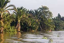 Martapura River outside Banjarmasin | |
| Native name | Sungai Martapura |
| Location | |
| Country | Indonesia |
| Province | South Kalimantan |
| Physical characteristics | |
| Source | |
| ⁃ location | Martapura, Banjar Regency |
| Mouth | Barito River |
Etymology
The river name is taken from the city of Martapura, which was a capital of Banjar Kingdom in around 1630, specifically in the area of Kayu Tangi (hence also the name "Kayutangi River").[11] Another name is "Tatas River" (Indonesian: Sungai Tatas), pointing to the delta Tatas, which in 1787 was acquired by the Dutch East India Company (now the downtown of modern city Banjarmasin).[12]
Hidrology
The watershed area (Indonesian: Daerah Aliran Sungai) Martapura has an area of 453.88 km2, with the main river length of 36,566 m, and with all tributaries has a total length of 375.91 km, giving a river density level of 0.828 km/km2.[13] The elevation difference between the upstream and downstream is 8.00 m, yielding a river gradient of 0.022%.[13] The upstream area is Riam Kanan Dam.[13]
Geography
The river flows in the southeast area of Borneo with predominantly tropical rainforest climate (designated as Af in the Köppen-Geiger climate classification).[14] The annual average temperature in the area is 25 °C. The warmest month is October, when the average temperature is around 28 °C, and the coldest is July, at 24 °C.[15] The average annual rainfall is 2767 mm. The wettest month is February, with an average of 366 mm rainfall, and the driest is September, with 75 mm rainfall.[16]
Gallery
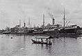 KPM ship at the dock of Martapura River in Banjarmasin
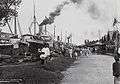 KPM ship at the dock of Martapura River in Banjarmasin
 A bridge over Martapura River in Banjarmasin
 Martapura River in Banjarmasin
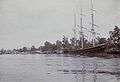 Martapura River
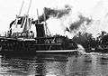 Martapura River
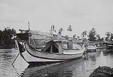 Madurese ship (golekan) docking in the bank of Martapura River
References
- Rand McNally, The New International Atlas, 1993.
- Sungai Martapura - Geonames.org.
- Müller, Salomon (1857). Reizen en onderzoekingen in den Indischen archipel, gedaan op last der nederlandsche indische regering, tusschen de jaren 1828 en 1836: Nieuwe uitgave, met verbeteringen (in Dutch).
- van Hoëvell, Wolter Robert (1838). Tijdschrift voor Nederlandsch Indië (in Dutch). 1. Ter Lands-drukkerij. p. 6.
- Nederlandsch-Indië (1838). "Tijdschrift voor Nederlandsch-Indië" (in Dutch). 1–2. Lands-drukk.: 6. Cite journal requires
|journal=(help) - Buddingh, Steven Adriaan (1861). Neêrlands-Oost-Indië: Reizen over Java, Madura, Makasser, Saleijer, Bima, Menado, Sangier-eilanden, Talau-eilanden, Ternate, Batjan, Gilolo en omliggende eilanden, Banda-eilanden, Amboina, Haroekoe, Saparoea, Noussalaut, Zuidkust van Ceram, Boeroe, Boano, Banka, Palembang, Riouw, Benkoelen, Sumatra's West-Kust, Floris, Timor, Rotty, Borneo's West-Kust, en Borneo's Zuid- en Oost-Kust; gedaan gedurende het tijdvak van 1852-1857 (in Dutch). M. Wijt. pp. 442.
de kleine Banjersche rivier.
- James Cook, A collection of voyages round the world: performed by royal authority. Containing a complete historical account of Captain Cook's first, second, third and last voyages, undertaken for making new discoveries, &c. ... To which are added genuine narratives of other voyages of discovery round the ... , Printed for A. Millar, W. Law, and R. Cater, 1790
- Salmon, Thomas (March 9, 1744). "Modern history or, the present state of all nations. Describing their respective situations, persons, habits, and buildings, manners, laws and customs ... plants, animals, and minerals". London : Printed for T. Longman [et al.] – via Internet Archive.
- https://atlantisjavasea.files.wordpress.com/2015/09/1726-herman-moll.jpg
- Eriza Islakul Ulmi, Nilna Amal. Kajian Ekohidraulik Sungai Martapura. Program Studi Teknik Sipil, Fakultas Teknik, Universitas Lambung Mangkurat, Banjarbaru.
- (in Indonesian) Mohamad Idwar Saleh, Banjarmasih: sejarah singkat mengenai bangkit dan berkembangnya kota Banjarmasin serta wilayah sekitarnya sampai dengan tahun 1950, Museum Negeri Lambung Mangkurat Propinsi Kalimantan Selatan, Direktorat Permuseuman, Direktorat Jenderal Kebudayaan, Departemen Pendidikan dan Kebudayaan, 1982
- James Cook, A collection of voyages round the world: performed by royal authrity. Containing a complete historical account of Captain Cook's first, second, third and last voyages, undertaken for making new discoveries, &c. ... To which are added genuine narratives of other voyages of discovery round the ... , Printed for A. Millar, W. Law, and R. Cater, 1790
- Sobatnu, Ferry; Irawan, Faris Ade; Salim, Agus. Identifikasi dan Pemetaan Morfometri Daerah Aliran Sungai Martapura menggunakan teknologi GIS. Jurnal Gradasi Teknik Sipil. 2017. Vol 1, No. 2. Halaman 45-52.
- Peel, M C; Finlayson, B L; McMahon, T A (2007). "Updated world map of the Köppen-Geiger climate classification". Hydrology and Earth System Sciences. 11. doi:10.5194/hess-11-1633-2007.
- "NASA Earth Observations Data Set Index". NASA. 30 January 2016.
- "NASA Earth Observations: Rainfall (1 month - TRMM)". NASA/Tropical Rainfall Monitoring Mission. 30 January 2016.
External links
![]()