Marshalltown, New Jersey
Marshalltown is an unincorporated community located within Mannington Township, in Salem County, New Jersey, United States.[1][2][3] It has also been known as Frogtown.[4]
Marshalltown, New Jersey | |
|---|---|
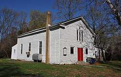 Church near Marshalltown Rd. and Roosevelt Ave. | |
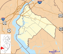 Marshalltown, New Jersey Marshalltown's location in Salem County (Inset: Salem County in New Jersey)  Marshalltown, New Jersey Marshalltown, New Jersey (New Jersey)  Marshalltown, New Jersey Marshalltown, New Jersey (the United States) | |
| Coordinates: 39°38′15″N 75°27′12″W | |
| Country | |
| State | |
| County | Salem |
| Township | Mannington |
| Elevation | 0.9 m (3 ft) |
| Time zone | UTC-5 (Eastern (EST)) |
| • Summer (DST) | UTC-4 (EDT) |
| GNIS feature ID | 878149[1] |
The community is centered at Marshalltown Road and Roosevelt Avenue, located 2.7 miles (4.3 km) southeast of Glenside and 3.6 miles (5.8 km) east-southeast of Pennsville.[5]
History
Located near the Salem River, Marshalltown was one of five pre-Civil War communities developed along tributaries of the Delaware River by freedmen.[6][7]
Before the abolition of slavery, these black-populated communities offered protection and aid to fugitive slaves, and "the likelihood that there was antebellum Underground Railroad activity is high".[6][7]
The settlement once contained many houses and gardens, a school, stores, and two churches. Mount Zion A.U.M.P. Church in Marshalltown is one of the earliest African Methodist churches.[8]
By 2010, only a school house, a church, and two cemeteries survived, and "isolation, theft, vandalism, and lack of historic preservation planning threaten the surviving cultural landscape of Marshalltown".[7]
References
- Feature Detail Report for: Marshalltown, Geographic Names Information System. Accessed January 1, 2015.
- Locality Search, State of New Jersey. Accessed January 1, 2015.
- Areas covering the point (-75.453333,39.6375), MapIt. Accessed January 1, 2015.
- "West Jersey History Project - Booka - Place Names of Salem County N.J. by Josephine Jaquett and Elmer VanName". www.westjerseyhistory.org.
Upper Penn's Neck Township. On Salem Creek, near Hawks' Bridge, on the farm of the late George H. Biddle. Quantities of tomatoes and other produce were carried from here thru the Canal to Wilmington and other points. This farm was later developed into the residential settlement known as Cedar Crest Manor.
- N 39.6375 W 75.453333, ACME Mapper. Accessed January 1, 2015.
- Calarco, Tom (2011). Places of the Underground Railroad: A Geographical Guide. ABC-CLIO. pp. 294, 295.
- Sheridan, Janet L. (October 30, 2010). "Survey and Documentation of Marshalltown, Mannington Township, Salem County, New Jersey" (PDF). Janet L. Sheridan. Archived from the original (PDF) on November 2, 2013.
- U.S. Geological Survey Geographic Names Information System: Mount Zion
Municipalities and communities of Salem County, New Jersey, United States | ||
|---|---|---|
| City | 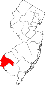 Map of New Jersey highlighting Salem County | |
| Boroughs | ||
| Townships | ||
| CDPs | ||
| Other unincorporated communities |
| |