Daretown, New Jersey
Daretown is an unincorporated community within Upper Pittsgrove Township in Salem County, New Jersey, United States.[1][2][3]
Daretown, New Jersey | |
|---|---|
 Daretown, New Jersey  Daretown, New Jersey  Daretown, New Jersey | |
| Coordinates: 39°36′15″N 75°15′27″W | |
| Country | |
| State | |
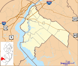
| County | Salem |
| Township | Upper Pittsgrove |
| Named for | Samuel Dare |
| Elevation | 41 m (135 ft) |
| Time zone | UTC-5 (Eastern (EST)) |
| • Summer (DST) | UTC-4 (EDT) |
| GNIS feature ID | 875799[1] |
Alloway Creek flows south of Daretown, while the Salem River flows to the north.
History
An early settler, Samuel Dare, opened a store in his house there, and also served as a church trustee. The settlement was named in his honor following his death in 1838.[4]
The historic Pittsgrove Baptist Church is located in Daretown, while the historic Pittsgrove Presbyterian Church is located southwest of Daretown.[4][5]
A depot of the Salem Railroad was erected in Daretown in 1863. The depot also served as the first post office. Daretown was a center for potato shipping from 1906 to 1923.[4]
A school was erected in 1876.[4]
By 1882, the population had grown to 250.[6]
References
- U.S. Geological Survey Geographic Names Information System: Daretown
- Google (January 25, 2015). "Daretown, Upper Pittsgrove Township, New Jersey" (Map). Google Maps. Google. Retrieved January 25, 2015.
- Locality Search, State of New Jersey
- Elwell, Bonny Beth (2013). Upper Pittsgrove, Elmer, and Pittsgrove. Arcadia. pp. 9, 14, 16, 19. ISBN 9781467120289.
- "History". Pittsgrove Presbyterian. Archived from the original on 2015-01-22. Retrieved January 2015. Check date values in:
|accessdate=(help) - Industries of New Jersey. Historical Publishing Company. 1882. p. 80. OL 24332547M.
Municipalities and communities of Salem County, New Jersey, United States | ||
|---|---|---|
| City | 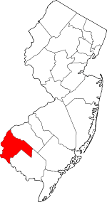 Map of New Jersey highlighting Salem County | |
| Boroughs | ||
| Townships | ||
| CDPs | ||
| Other unincorporated communities |
| |