Marceline, Missouri
Marceline is a city in Chariton and Linn counties in the U.S. state of Missouri. The population was 2,221 at the 2010 census.
Marceline, Missouri | |
|---|---|
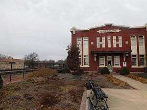 The former Atchison, Topeka and Santa Fe Railway depot in Marceline in February 2017, now as the Walt Disney Hometown Museum. | |
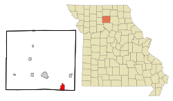 Location within Linn County and Missouri | |
| Coordinates: 39°42′52″N 92°56′51″W | |
| Country | United States |
| State | Missouri |
| Counties | Linn, Chariton |
| Government | |
| • Mayor | Jeri Holt |
| • City Manager | Richard Hoon |
| Area | |
| • Total | 3.32 sq mi (8.60 km2) |
| • Land | 3.28 sq mi (8.50 km2) |
| • Water | 0.04 sq mi (0.10 km2) |
| Elevation | 863 ft (263 m) |
| Population | |
| • Total | 2,233 |
| • Estimate (2018)[3] | 2,107 |
| • Density | 670/sq mi (260/km2) |
| Time zone | UTC-6 (Central (CST)) |
| • Summer (DST) | UTC-5 (CDT) |
| ZIP code | 64658 |
| Area code(s) | 660 Exchange: 376 |
| FIPS code | 29-45866 [4] |
| GNIS feature ID | 0721859 [5] |
| Website | marceline.org |
History
Marceline was laid out in 1887, and named after the wife of a railroad man.[6] A post office called Marceline has been in operation since 1887.[7]
Geography
Marceline is located at 39°42′52″N 92°56′51″W (39.714314, -92.947376).[8]
According to the United States Census Bureau, the city has a total area of 3.32 square miles (8.60 km2), of which 3.28 square miles (8.50 km2) is land and 0.04 square miles (0.10 km2) is water.[1]
Climate
| Climate data for Marceline, MO | |||||||||||||
|---|---|---|---|---|---|---|---|---|---|---|---|---|---|
| Month | Jan | Feb | Mar | Apr | May | Jun | Jul | Aug | Sep | Oct | Nov | Dec | Year |
| Record high °F (°C) | 74 (23) |
79 (26) |
86 (30) |
92 (33) |
98 (37) |
106 (41) |
116 (47) |
108 (42) |
103 (39) |
95 (35) |
82 (28) |
72 (22) |
116 (47) |
| Average high °F (°C) | 33 (1) |
40 (4) |
52 (11) |
63 (17) |
73 (23) |
82 (28) |
87 (31) |
85 (29) |
77 (25) |
67 (19) |
50 (10) |
37 (3) |
62 (17) |
| Average low °F (°C) | 14 (−10) |
19 (−7) |
30 (−1) |
40 (4) |
51 (11) |
61 (16) |
66 (19) |
64 (18) |
54 (12) |
43 (6) |
30 (−1) |
19 (−7) |
41 (5) |
| Record low °F (°C) | −21 (−29) |
−18 (−28) |
−15 (−26) |
13 (−11) |
29 (−2) |
41 (5) |
46 (8) |
43 (6) |
30 (−1) |
16 (−9) |
−7 (−22) |
−24 (−31) |
−24 (−31) |
| Average precipitation inches (mm) | 1.50 (38) |
1.48 (38) |
2.74 (70) |
3.61 (92) |
4.78 (121) |
4.11 (104) |
4.74 (120) |
4.08 (104) |
4.38 (111) |
3.34 (85) |
2.96 (75) |
2.01 (51) |
39.73 (1,009) |
| Average snowfall inches (cm) | 5.5 (14) |
4.2 (11) |
2.9 (7.4) |
0.4 (1.0) |
0 (0) |
0 (0) |
0 (0) |
0 (0) |
0 (0) |
0 (0) |
1 (2.5) |
4.4 (11) |
18.4 (46.9) |
| Source: [9] | |||||||||||||
Demographics
| Historical population | |||
|---|---|---|---|
| Census | Pop. | %± | |
| 1880 | 872 | — | |
| 1890 | 1,977 | 126.7% | |
| 1900 | 2,638 | 33.4% | |
| 1910 | 3,920 | 48.6% | |
| 1920 | 3,760 | −4.1% | |
| 1930 | 3,555 | −5.5% | |
| 1940 | 3,206 | −9.8% | |
| 1950 | 3,172 | −1.1% | |
| 1960 | 2,872 | −9.5% | |
| 1970 | 2,622 | −8.7% | |
| 1980 | 2,938 | 12.1% | |
| 1990 | 2,645 | −10.0% | |
| 2000 | 2,558 | −3.3% | |
| 2010 | 2,233 | −12.7% | |
| Est. 2018 | 2,107 | [3] | −5.6% |
| U.S. Decennial Census[10] | |||
2010 census
At the 2010 census there were 2,233 people, 970 households, and 606 families living in the city. The population density was 680.8 inhabitants per square mile (262.9/km2). There were 1,151 housing units at an average density of 350.9 per square mile (135.5/km2). The racial makeup of the city was 98.0% White, 0.3% African American, 0.1% Native American, 0.1% Asian, 0.2% from other races, and 1.3% from two or more races. Hispanic or Latino of any race were 1.4%.[2]
Of the 970 households 30.5% had children under the age of 18 living with them, 48.4% were married couples living together, 9.4% had a female householder with no husband present, 4.7% had a male householder with no wife present, and 37.5% were non-families. 34.0% of households were one person and 16.8% were one person aged 65 or older. The average household size was 2.30 and the average family size was 2.94.
The median age was 39.8 years. 25.1% of residents were under the age of 18; 7.7% were between the ages of 18 and 24; 22.8% were from 25 to 44; 26% were from 45 to 64; and 18.3% were 65 or older. The gender makeup of the city was 46.6% male and 53.4% female.
2000 census
At the 2000 census there were 2,558 people, 1,079 households, and 690 families living in the city. The population density was 787.1 people per square mile (303.9/km²). There were 1,237 housing units at an average density of 380.6/sq mi (147.0/km²). The racial makeup of the city was 98.20% White, 0.12% African American, 0.78% Native American, 0.20% Asian, 0.20% from other races, and 0.51% from two or more races. Hispanic or Latino of any race were 0.82%.[4]
Of the 1,079 households 31.0% had children under the age of 18 living with them, 48.8% were married couples living together, 11.4% had a female householder with no husband present, and 36.0% were non-families. 32.4% of households were one person and 17.6% were one person aged 65 or older. The average household size was 2.32 and the average family size was 2.95.
The age distribution was 26.7% under the age of 18, 7.6% from 18 to 24, 24.4% from 25 to 44, 21.7% from 45 to 64, and 19.6% 65 or older. The median age was 39 years. For every 100 females, there were 84.7 males. For every 100 females age 18 and over, there were 78.2 males.
The median household income was $25,164 and the median family income was $35,948. Males had a median income of $26,786 versus $17,382 for females. The per capita income for the city was $15,086. About 9.0% of families and 13.1% of the population were below the poverty line, including 15.3% of those under age 18 and 19.5% of those age 65 or over.
Education
Public education in Marceline is administered by the Marceline R-V School District.[11]
Marceline has a public library, the Marceline Carnegie Library.[12]
Notable person
- Walt Disney, animator and founder of The Walt Disney Company, spent four years of his childhood on a farm near Marceline. Main Street, U.S.A., a land found in Disneyland as well as in other Disney theme parks worldwide, was inspired by Disney's childhood growing up in Marceline.[13] The Walt Disney Hometown Museum is located in the former Santa Fe rail depot in Marceline.[14]
References
- "US Gazetteer files 2010". United States Census Bureau. Archived from the original on 2012-01-24. Retrieved 2012-07-08.
- "U.S. Census website". United States Census Bureau. Retrieved 2012-07-08.
- "Population and Housing Unit Estimates". Retrieved December 19, 2019.
- "U.S. Census website". United States Census Bureau. Retrieved 2008-01-31.
- "US Board on Geographic Names". United States Geological Survey. 2007-10-25. Retrieved 2008-01-31.
- "Linn County Place Names, 1928–1945". The State Historical Society of Missouri. Archived from the original on June 24, 2016. Retrieved October 29, 2016.
- "Post Offices". Jim Forte Postal History. Retrieved 29 October 2016.
- "US Gazetteer files: 2010, 2000, and 1990". United States Census Bureau. 2011-02-12. Retrieved 2011-04-23.
- http://www.intellicast.com/Local/History.aspx?location=USMO0555
- "Census of Population and Housing". Census.gov. Retrieved June 4, 2015.
- "Homepage". Marceline R-V School District. Retrieved 4 June 2019.
- "Missouri Public Libraries". PublicLibraries.com. Archived from the original on 10 June 2017. Retrieved 2 June 2019.
- "Local History Archive Larimer Legends – Old Town & Disneyland – City of Fort Collins, Colorado". Library.ci.fort-collins.co.us. Archived from the original on 2009-01-25. Retrieved 2013-12-19.
- Walt Disney, American Experience, ISBN 978-1627894166
Further reading
- Barrier, J. Michael. (2007), "The Pet in the Family: On the Farm and in the City, 1901-1923", The Animated Man: A Life of Walt Disney, University of California Press, ISBN 978-0520241176
External links
| Wikivoyage has a travel guide for Marceline. |
- Official website
- Historic maps of Marceline in the Sanborn Maps of Missouri Collection at the University of Missouri
Municipalities and communities of Chariton County, Missouri, United States | ||
|---|---|---|
| Cities | 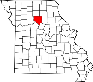 Map of Missouri highlighting Chariton County | |
| Villages | ||
| Townships | ||
| Unincorporated communities | ||
| Footnotes | ‡This populated place also has portions in an adjacent county or counties | |
Municipalities and communities of Linn County, Missouri, United States | ||
|---|---|---|
| Cities | 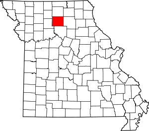 Map of Missouri highlighting Linn County | |
| Townships |
| |
| Unincorporated communities | ||
| Footnotes | ‡This populated place also has portions in an adjacent county or counties | |