Maple Park, Illinois
Maple Park is a village in DeKalb and Kane counties in the U.S. state of Illinois. The population was 1,310 at the 2010 census,[3] up from 765 in 2000. Maple Park was formerly known as Lodi.
Maple Park, Illinois | |
|---|---|
Village | |
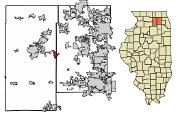 Location of Maple Park in DeKalb County, Illinois | |
.svg.png) Location of Illinois in the United States | |
| Coordinates: 41°54′31″N 88°35′53″W | |
| Country | United States |
| State | Illinois |
| Counties | DeKalb, Kane |
| Townships | Cortland, Pierce, Virgil |
| Government | |
| • Village President | Kathy Curtis |
| Area | |
| • Total | 2.28 sq mi (5.90 km2) |
| • Land | 2.28 sq mi (5.90 km2) |
| • Water | 0.00 sq mi (0.01 km2) |
| Population (2010) | |
| • Total | 1,310 |
| • Estimate (2018)[2] | 1,337 |
| • Density | 572.93/sq mi (221.18/km2) |
| Time zone | UTC-6 (CST) |
| • Summer (DST) | UTC-5 (CDT) |
| ZIP Code(s) | 60151 |
| Area code(s) | 815 |
| FIPS code | 17-46604 |
| Wikimedia Commons | Maple Park, Illinois |
| Website | www |
History
Maple Park was originally called "Lodi", after Lodi, Lombardy.[4] The present name comes from a nearby grove of sugar maple trees.[4] A post office called "Lodi" was established first in 1837, and the post office was renamed "Maple Park" in 1880.[5]
Geography
Maple Park is located at 41°54′31″N 88°35′53″W (41.908514, -88.597989),[6] with the majority of the population in Kane County but with more area in DeKalb County. Illinois Route 38 runs through the southern side of the village, leading east 15 miles (24 km) to Geneva and west 8 miles (13 km) to DeKalb. It is 52 miles (84 km) west of downtown Chicago.
According to the 2010 census, Maple Park has a total area of 2.353 square miles (6.09 km2), of which 2.35 square miles (6.09 km2) (or 99.87%) is land and 0.003 square miles (0.01 km2) (or 0.13%) is water.[7]
Demographics
| Historical population | |||
|---|---|---|---|
| Census | Pop. | %± | |
| 1880 | 385 | — | |
| 1890 | 382 | −0.8% | |
| 1900 | 391 | 2.4% | |
| 1910 | 389 | −0.5% | |
| 1920 | 384 | −1.3% | |
| 1930 | 389 | 1.3% | |
| 1940 | 398 | 2.3% | |
| 1950 | 433 | 8.8% | |
| 1960 | 592 | 36.7% | |
| 1970 | 660 | 11.5% | |
| 1980 | 637 | −3.5% | |
| 1990 | 641 | 0.6% | |
| 2000 | 765 | 19.3% | |
| 2010 | 1,310 | 71.2% | |
| Est. 2018 | 1,337 | [2] | 2.1% |
| U.S. Decennial Census[8] | |||
At the 2000 census there were 765 people, 280 households, and 208 families in the village. The population density was 1,288.1 people per square mile (500.6/km²). There were 289 housing units at an average density of 486.6 per square mile (189.1/km²). The racial makeup of the village was 97.52% White, 0.39% Native American, 0.13% Asian, 0.92% from other races, and 1.05% from two or more races. Hispanic or Latino of any race were 2.48%.[9]
Of the 280 households 39.6% had children under the age of 18 living with them, 58.9% were married couples living together, 11.1% had a female householder with no husband present, and 25.7% were non-families. 21.8% of households were one person and 8.2% were one person aged 65 or older. The average household size was 2.73 and the average family size was 3.23.
The age distribution was 28.9% under the age of 18, 9.3% from 18 to 24, 31.4% from 25 to 44, 22.0% from 45 to 64, and 8.5% 65 or older. The median age was 34 years. For every 100 females, there were 105.6 males. For every 100 females age 18 and over, there were 106.1 males.
The median household income was $49,583 and the median family income was $54,821. Males had a median income of $41,563 versus $26,645 for females. The per capita income for the village was $21,932. About 4.5% of families and 5.8% of the population were below the poverty line, including 7.0% of those under age 18 and 3.2% of those age 65 or over.
Education
Kaneland Community Unit School District 302 operates Kaneland High School.
See also
- Kuipers Family Farm, located in Maple Park
References
- "2016 U.S. Gazetteer Files". United States Census Bureau. Retrieved Jun 29, 2017.
- "Population and Housing Unit Estimates". Retrieved February 2, 2020.
- "Geographic Identifiers: 2010 Demographic Profile Data (G001): Maple Park village, Illinois". American Factfinder. U.S. Census Bureau. Retrieved February 12, 2019.
- Chicago and North Western Railway Company (1908). A History of the Origin of the Place Names Connected with the Chicago & North Western and Chicago, St. Paul, Minneapolis & Omaha Railways. p. 98.
- "County". Jim Forte Postal History. Retrieved 22 March 2015.
- "US Gazetteer files: 2010, 2000, and 1990". United States Census Bureau. 2011-02-12. Retrieved 2011-04-23.
- "G001 - Geographic Identifiers - 2010 Census Summary File 1". United States Census Bureau. Archived from the original on 2020-02-13. Retrieved 2015-10-26.
- "Census of Population and Housing". Census.gov. Retrieved June 4, 2015.
- "U.S. Census website". United States Census Bureau. Retrieved 2008-01-31.
External links
Municipalities and communities of DeKalb County, Illinois, United States | ||
|---|---|---|
| Cities | Map of Illinois highlighting DeKalb County | |
| Town | ||
| Villages | ||
| Townships | ||
| Unincorporated communities | ||
| Ghost towns | ||
| Footnotes | ‡This populated place also has portions in an adjacent county or counties | |
Municipalities and communities of Kane County, Illinois, United States | ||
|---|---|---|
| Cities | Map of Illinois highlighting Kane County | |
| Villages | ||
| Townships | ||
| CDP | ||
| Other unincorporated communities | ||
| Footnotes | ‡This populated place also has portions in an adjacent county or counties | |