Manuherikia River
The Manuherikia River is located in Otago in the South Island of New Zealand. It rises in the far north of the Maniototo, with the West Branch draining the eastern side of the St Bathans Range, and the East Branch draining the western flanks of the Hawkdun Range. The river continues southwest through the wide Manuherikia Valley to its confluence with the Clutha River at Alexandra. During the 1860s the Manuherikia was one of the centres of the Central Otago Gold Rush.
| Manuherikia River | |
|---|---|
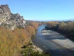 Manuherikia River flowing south near Poolburn Gorge | |
| Location | |
| Country | New Zealand |
| Physical characteristics | |
| Source | |
| ⁃ location | Maniototo |
| Mouth | |
⁃ location | Clutha River |
⁃ elevation | 132 m (433 ft) |
| Length | 85 km (53 mi) |
The river is crossed by two historically significant bridges, the curved Manuherikia Bridge No.1 (number 70 on the Otago Central Railway line), a concrete pier bridge completed in 1903, and a stone pier bridge at Ophir built in 1880.[1]
References
- Bridge at Ophir (from Te Ara: The Encyclopedia of New Zealand website. Accessed 2014-02-18.)
This article is issued from Wikipedia. The text is licensed under Creative Commons - Attribution - Sharealike. Additional terms may apply for the media files.