Malinau Regency
Malinau Regency is a regency of North Kalimantan Province in Indonesia. The administrative centre is the town of Malinau. Malinau is also often called Earth Intimung. The district is home to the Kayan Mentarang National Park. It covers an area of 40,088.41 km2, and had a population of 62,423 at the 2010 Census; the latest official estimate (as at 2019) is 90,382.[2] In terms of demographics and religion, Malinau is the only regency in North Kalimantan that is predominantly Protestant.
Malinau Regency | |
|---|---|
Regency | |
 Seal | |
| Motto(s): Intimung (meaning: Beautiful, Orderly, Prosperous and Excellence) | |
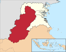 Location of Malinau Regency in North Kalimantan | |
 Malinau Regency Location in Borneo  Malinau Regency Malinau Regency (Indonesia) | |
| Coordinates: 3°29′0″N 115°42′0″E | |
| Country | Indonesia |
| Province | North Kalimantan |
| Government | |
| • Regent | Yansen Tipa Padan |
| Area | |
| • Total | 40,088.41 km2 (15,478.22 sq mi) |
| Population (2019) | |
| • Total | 90,382 |
| • Density | 2.3/km2 (5.8/sq mi) |
| [1] | |
| Time zone | UTC+8 (Central Indonesian Time) |
| Area code(s) | +62 553 |
| Website | malinau.go.id |
Administration
As at 2010, the regency was divided into twelve districts (kecamatan), but in 2012 three additional districts were created by the division of the existing Malinau Selatan and Mentarang districts. The fifteen districts are tabulated below with their present areas and their 2010 Census populations, together with the latest (as at 2019) official estimates.[3]
| Name | (English name) | Area km2 | Population Census 2010 | Population Estimate 2019 |
|---|---|---|---|---|
| Sungai Boh | 3,112.18 | 2,148 | 3,102 | |
| Kayan Selatan | (South Kayan) | 3,138.59 | 1,711 | 2,472 |
| Kayan Hulu | (Upper Kayan) | 735.40 | 2,535 | 3,661 |
| Kayan Hilir | (Lower Kayan) | 11,863.19 | 1,352 | 1,952 |
| Pujungan | 6,539.39 | 1,800 | 2,599 | |
| Bahau Hulu | (Upstream Bahau) | 3,098.98 | 1,460 | 2,109 |
| Sungai Tubu | 2,243.78 | (a) | 1,175 | |
| Malinau Selatan | (South Malinau) | 1,153.35 | 7,999 | 5,656 |
| Malinau Selatan Hulu | (Upper South Malinau) | 2,171.14 | (b) | 2,797 |
| Malinau Selatan Hilir | (Lower South Malinau) | 572.20 | (b) | 3,098 |
| Mentarang | 535.15 | 5,291 | 6,468 | |
| Mentarang Hulu | (Upstream Mentarang) | 2,924.65 | 696 | 1,092 |
| Malinau Utara | (North Malinau) | 1,091.19 | 10,124 | 14,622 |
| Malinau Barat | (West Malinau) | 767.12 | 8,157 | 11,782 |
| Malinau | Malinau town | 142.07 | 19,247 | 27,797 |
Notes: (a) included in 2010 population of Mentarang district, from which it was split in 2012.
(b) included in 2010 population of Malinau Selatan district, from which it was split in 2012.
History
Malinau was originally a residential area inhabited by the Tidung ethnic group. Based on information from Tidung community leaders, the name Malinau originated when the Dutch settled an area formerly known as Desa (village) Selamban. At the time Desa Selamban was inhabited by the Tidung Tribe, while across the Kabiran river the village Pelita Canaan was inhabited by the Dayak Abai tribe. When the Dutch arrived in the Desa Selamban they met a group of Abai who were harvesting sago from the sago palm, and asked the name of the river that ran between the two villages. The Abai did not understand the questions, and assumed the Dutch wanted to know what they were working on. One of the Abai said "Mal Inau" which means harvesting sago in the local Abai language; "mal" meaning making, while "inau" means tree. Thus the name Malinau was born. A map of the area made during the colonial period called the local river "the Malinau", and the area has been known as Malinau since.
As people migrated into the area Desa Selamban eventually grew much larger and became a town, renamed Malinau. When Bulungan Regency was divided in 1999, Malinau became the administrative centre of the newly formed Malinau Regency. In December 2012, Malinau Regency became part of the new province of North Kalimantan.
Ethnic Groups
There are a number of indigenous groups in Malinau, namely:
- Tidung
- Kenyah
- Burusu
- Tagal
- Iban
- Merap
- Punan
- Lun Bawang / Lun Dayeh
- Abbay
- Murut
References
- Badan Pusat Statistik, Jakarta, 2019.
- Badan Pusat Statistik, Jakarta, 2019.
- https://malinaukab.bps.go.id/statictable
External links
- (in Indonesian) Kabupaten Malinau. Harian Kompas, 17 Juni 2003
- (in Indonesian) Daerah Konservasi Mestinya Dapat Kompensasi. Harian Kompas, 15 December 2004
- (in Indonesian) Daun Penyedap Masakan dari Malinau, Kalimantan Timur. Riskan Efendi
- (in Indonesian) Malinau Narsis
- (in Indonesian) Blog tentang Malinau
Regencies and cities of North Kalimantan | ||
|---|---|---|
Capital: Tanjung Selor | ||
| Regencies | ||
| Cities | ||