Maine State Route 176
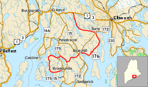
State Route 176 (SR 176) is part of Maine's system of numbered state highways, located in Hancock County. The 38-mile-long (61 km) route runs in a vertical zig-zag direction, but it is mostly signed as an east–west route. The western terminus of the route is at SR 175 in Brooksville and its eastern terminus is at U.S. Route 1 (US 1) and SR 3 in Orland.
| ||||
|---|---|---|---|---|
 | ||||
| Route information | ||||
| Maintained by MaineDOT | ||||
| Length | 38.04 mi[1] (61.22 km) | |||
| Existed | 1925–present | |||
| Major junctions | ||||
| West end | ||||
| East end | ||||
| Location | ||||
| Counties | Hancock | |||
| Highway system | ||||
| ||||

Junction list
The entire route is in Hancock County.
| Location | mi | km | Destinations | Notes | |
|---|---|---|---|---|---|
| Brooksville | 0.00 | 0.00 | Western terminus of SR 176 | ||
| 10.0 | 16.1 | Western end of SR 175 concurrency | |||
| Sedgwick | 11.1 | 17.9 | Eastern end of SR 175 concurrency | ||
| 13.5 | 21.7 | Western end of SR 15concurrency | |||
| Blue Hill | 17.6 | 28.3 | Western end of SR 172 concurrency; northern terminus of SR 175 | ||
| 18.2 | 29.3 | Eastern terminus of SR 177 | |||
| 18.3 | 29.5 | Eastern end of SR 15 concurrency | |||
| 18.5 | 29.8 | Eastern end of SR 172 concurrency | |||
| Surry | 28.7 | 46.2 | Western end of SR 172 concurrency | ||
| 28.8 | 46.3 | Eastern end of SR 172 concurrency | |||
| Orland | 38.27 | 61.59 | Eastern terminus of SR 176 | ||
1.000 mi = 1.609 km; 1.000 km = 0.621 mi
| |||||
References
- Maine DOT Map Viewer (Map). Maine Office of GIS. Retrieved October 20, 2017.
External links
This article is issued from Wikipedia. The text is licensed under Creative Commons - Attribution - Sharealike. Additional terms may apply for the media files.