Magway Region
Magway Region (Burmese: မကွေးတိုင်းဒေသကြီး, pronounced [məɡwé táiɰ̃ dèθa̰ dʑí], formerly Magway Division) is an administrative division in central Myanmar. It is the second largest of Myanmar's seven divisions, with an area of 44,820 km2 (17,306 square miles). Pa Del Dam (ပဒဲဆည်) is one of the dams in Aunglan Township, Magway Division. The capital and second largest city of the Magway Division is Magway. The largest city is Pakokku. The major cities of Magway Division are Magway, Pakokku, Chauk, Aunglan, Yenangyaung, Taungdwingyi, Minbu, Thayet and Gangaw.
Magway Region မကွေးတိုင်းဒေသကြီး | |
|---|---|
Division | |
| Myanma transcription(s) | |
| • Burmese | ma. kwe: tuing: desa. kri: |
 Flag  Seal | |
 Location of Magway Region in Myanmar | |
| Coordinates: 20°15′N 94°45′E | |
| Country | |
| Region | Central |
| Capital | Magway |
| Government | |
| • Chief Minister | Aung Moe Nyo (NLD) |
| • Cabinet | Magway Region Government |
| • Legislature | Magway Region Hluttaw |
| • Judiciary | Magway Region High Court |
| Area | |
| • Total | 44,820.6 km2 (17,305.3 sq mi) |
| Area rank | 4th |
| Population (2014)[1] | |
| • Total | 3,917,055 |
| • Rank | 7th |
| • Density | 87/km2 (230/sq mi) |
| Demonym(s) | Magwegian |
| Demographics | |
| • Ethnicities | Bamar, Chin, Rakhine, Shan, Karen |
| • Religions | Buddhism 98.8% Christianity 0.7% Islam 0.3% Hinduism 0.1% animism 0.1% |
| Time zone | UTC+06:30 (MST) |
| HDI (2017) | 0.560[2] medium · 6th |
Geography
Mayway Region sits approximately between north latitude 18° 50' to 22° 47' and east longitude 93° 47' to 95° 55'. It is bordered by Sagaing Region to the north, Mandalay Region to the east, Bago Region to the south, and Rakhine State and Chin State to the west.
History
Fossils of the early primates over 40 million years old were excavated in the Pondaung and Ponnya areas from Pakokku District in Magway Region, leading the government to proclaim that Myanmar as "the birthplace of humanity in the world," a claim which is unsupported by anthropologists. An ancient city of the Pyu, Peikthano-myo, about 2,000 years old, is located in Taungdwingyi Township, Magway Region.
The history of Magway Region mirrors that of the other divisions of central Burma. The ancient name of Magway Region is Minbu Region (or) Minbu Province. Minbu Region was established with 3 districts. They are Minbu District, Thayet District, and Yenangyaung District. Its capital city was Yenangyaung.
On 2 March 1962, the military led by General Ne Win took control of Burma through a coup d'état, and the government has been under direct or indirect control by the military. A new constitution of the Socialist Republic of the Union of Burma was adopted in 1974.
The name of Minbu Region was changed to Magway Region and Yenangyaung District was abolished. Magway District was established with 6 townships.Pakokku Hill Tracts (or) Pakokku Province was abolished, and Pakokku District was added to the Magway Division and Mindat District was added to the Chin state. Magway Region was then divided into 4 districts: Magway District, Minbu District, Thayet District and Pakokku District. Its capital city was changed from Yenangyaung to Magway.
In 4th April 1996, Pakokku District was divided into two districts: Pakokku District and Gangaw District. Currently, Magway Region has a total of 5 districts and 25 townships.
Administrative divisions
Magway Region's districts are Magwe, Minbu, Thayet, Pakokku and Gangaw, comprising 25 townships and 1,696 ward village tracts. Its capital city is Magwe (2019 urban population estimated as 84,754) and its largest city is Pakokku (2019 urban population estimated as 107,557).
Other major cities are Chauk (2019 urban population estimated as 54,138), Aunglan (2019 urban population estimated as 52,865), Yenangyaung (2019 urban population estimated as 49,588), Taungdwingyi (2019 urban population estimated as 47,537) and Minbu (2019 urban population estimated as 39,884).
List of cities and towns by urban population
| Rank | City | District | 2014 Census (2019 Estimate) | 1993 Estimate | Change |
|---|---|---|---|---|---|
| 1 | Pakokku | Pakokku District | 107,557 | 90,783 | +18.48% |
| 2 | Magway | Magway District | 84,754 | 72,388 | +17.08% |
| 3 | Chauk | Magway District | 54,138 | 67,845 | −20.20% |
| 4 | Aunglan | Thayet District | 52,865 | 43,223 | +22.31% |
| 5 | Yenangyaung | Magway District | 49,588 | 90,845 | −45.41% |
| 6 | Taungdwingyi | Magway District | 47,537 | 52,335 | −9.17% |
| 7 | Minbu | Minbu District | 39,884 | 42,809 | −6.83% |
| 8 | Yesagyo | Pakokku District | 23,603 | 23,329 | +1.17% |
| 9 | Salin | Minbu District | 20,401 | 12,158 | +67.80% |
| 10 | Thayet | Thayet District | 20,278 | 46,361 | −56.26% |
| 11 | Natmauk | Magway District | 14,412 | 14,737 | −2.21% |
| 12 | Minhla | Thayet District | 12,449 | 12,510 | −0.49% |
| 13 | Gangaw | Gangaw District | 11,955 | 13,955 | −14.33% |
| 14 | Saw | Gangaw District | 9,706 | 7,078 | +37.13% |
| 15 | Seikphyu | Pakokku District | 9,174 | 9,081 | +1.02% |
| 16 | Myothit | Magway District | 9,089 | 8,080 | +12.49% |
| 17 | Myaing | Pakokku District | 8,294 | 7,706 | +7.63% |
| 18 | Pauk | Pakokku District | 7,820 | 7,286 | +7.33% |
| 19 | Pwintbyu | Minbu District | 6,476 | 5,350 | +21.05% |
| 20 | Mindon | Thayet District | 5,405 | 5,098 | +6.02% |
| 21 | Kamma | Thayet District | 5,129 | 5,202 | −1.40% |
| 22 | Sinbaungwe | Thayet District | 5,025 | 5,089 | −1.26% |
| 21 | Sidoktaya | Minbu District | 4,971 | 6,514 | −23.69% |
| 24 | Htilin | Gangaw District | 4,679 | 4,348 | +7.61% |
| 25 | Ngape | Minbu District | 4,138 | 6,514 | −36.48% |
Government
Executive
Legislature
Judiciary
Magway Region High Court
| Historical population | ||
|---|---|---|
| Year | Pop. | ±% |
| 1973 | 2,634,757 | — |
| 1983 | 3,243,166 | +23.1% |
| 2014 | 3,917,055 | +20.8% |
| Source: 2014 Myanmar Census[1] | ||
Demographics
Religion in Magway Region (2014)[3]
The population of Magway Region is 3,912,711 in 2014. Over 95% the people are Bamar, with very small numbers of minorities including Chin, Rakhine, Karen, Shan, and a tiny Anglo-Burmese population. During colonial times, this part of Burma had a large Anglo-Burmese population, descended from Western oil workers and their Burmese partners.
Religion
Approximately 99% of the population are Buddhists.
Transport
The Irrawaddy River is the major transportation system in Magway Region, both in terms of volume of goods and population served. Most major towns in the region are river ports on the Irrawaddy; among them are Magway, Pakokku, Minbu, Yenangyaung, Chauk, Allanmyo, and Thayetmyo. Pakokku's river port is a major port of Magway Region and the third most important river port in Myanmar after Yangon port and Mandalay port.
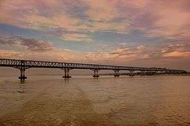
The major form of transport for non-Irrawaddy areas is by road. The road system is less developed on the western side of the river. The towns are connected with two-lane roads. Most towns have regular bus transportation to Rangoon (Yangon) and Mandalay.Pakokku Bridge is part of the India–Myanmar–Thailand Trilateral Highway and is the longest bridge in Myanmar.
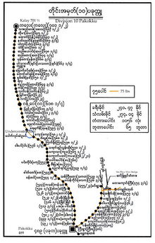
Division 10 Pakokku
The Pyay to Nyaung-U, Pakokku and Myingyan railway runs through eastern Magway with connections to the capital Naypyidaw, Rangoon and Mandalay. The major stops in Magway on that line are Taungdwingyi and Natmauk. In addition, there are two rail lines running north from the Irrawaddy port of Kyangin, one to Chaung-U in Sagaing Region and the other to the Myittha River valley past Myaing and Kyaw.[5]
The capital Magway has a small non-commercial airport with air traffic for the city of Magway mostly coming in through Bagan Airport at Nyaung U some 113 km to the north along the Irrawaddy. There are commercial airports at Gangaw, Kyauktu,[6] Pakokku, and Pauk.[5] As of 2018, however, none of them have regularly scheduled flights. Pakokku airport, however, plans to upgrade to an international airport soon.
Economy

The principal product of Magway Region is petroleum. It produces most of the oil and natural gas in Burma. Magway Region's oil fields are located in Mann, Yenangyaung, Chauk, Kyauk-khwet, Letpando and Ayadaw.[7]
In May 2002, Russia agreed to help Myanmar build a 10-megawatt nuclear reactor and two laboratories in the region.[8] Other industries include cement, cotton weaving, and tobacco, iron and bronze. Magway Region produces a large quantity of edible oil as well as petroleum, hence gaining its reputation as the "oil pot of Myanmar".
Pakokku is the largest rice market city of Upper Myanmar(Burma). Agriculture is another important practice, the major crops being sesamum and groundnut. Other crops grown are rice, millet, maize, sunflower, beans and pulses, tobacco, toddy, chili, onions, and potatoes. Famous products of Magway Region include Thanaka (Limonia acidissima) and Phangar (Chebulic myrobalan) fruit.
Only Pakokku and Yenangyaung have industrial zones.
The Largest Rice Market of Upper Myanmar
Pakokku is the biggest rice market in Upper Myanmar due to the rice requirement of the region itself and being a door to Chin State which also needs rice. Of the incoming rice to Pakokku, 70% is from the Ayeyawady Region (Myaungmya, Hinthada and Myanaung) and 30% is from Shwebo and Ye-U of the Sagaing Region. Some 20% of rice coming into the market of Pakokku is consumed by Pakokku itself, and the remaining 80% is sent to other township markets. Most buyers are from Myaing, Yesagyo, Pauk, Myingyan, Kalaymyo and Chin State. In the Pakokku market, consumption is 15% for top class, 50% for middle class and 35% for lower class rice. There are about 5 large rice wholesalers and 10 small rice wholesalers. A large rice wholesaler sells 500 to 1,500 bags per day, so it can sell 180,000 to 200,000 bags (9,000-10,000 tons) a year. Due to the smooth transportation and the booming market, the rice price becomes very high. Thus, the rice market in Pakokku has increased to double that of the Mandalay market.
Education
As of 2002, Magway Region have 3859 schools, of which only 70 are high schools.[9] Only about 10% of the division's primary school students reach high school.
| AY 2002-2003 | Primary | Middle | High |
|---|---|---|---|
| Schools | 3605 | 184 | 70 |
| Teachers | 14,800 | 3730 | 1377 |
| Students | 428,000 | 128,000 | 44,000 |
Most of 12 colleges and universities in the division are located in Magway, Pakokku and Yenangyaung.
Health care
The general state of health care in Myanmar is poor. The military government spends anywhere from 0.5% to 3% of the country's GDP on health care, consistently ranking among the lowest in the world.[10][11] Although health care is nominally free, in reality, patients have to pay for medicine and treatment, even in public clinics and hospitals. Public hospitals lack many of the basic facilities and equipment. Moreover, the health care infrastructure outside of Yangon and Mandalay is extremely poor. As of 2003, Magway Region had less than a quarter of hospital beds than Yangon Region with a slightly greater population.[12]
| 2002–2003 | # Hospitals | # Beds |
|---|---|---|
| Specialist hospitals | 0 | 0 |
| General hospitals with specialist services | 3 | 550 |
| General hospitals | 25 | 750 |
| Health clinics | 36 | 576 |
| Total | 64 | 1916 |
Notable sites
References
- Census Report. The 2014 Myanmar Population and Housing Census. 2. Naypyitaw: Ministry of Immigration and Population. May 2015. p. 17.
- "Sub-national HDI - Area Database - Global Data Lab". hdi.globaldatalab.org. Retrieved 2018-09-13.
- Department of Population Ministry of Labour, Immigration and Population MYANMAR (July 2016). The 2014 Myanmar Population and Housing Census Census Report Volume 2-C. Department of Population Ministry of Labour, Immigration and Population MYANMAR. pp. 12–15.
- Division 10 Pakokku
- "Map of Magway Division" Myanmar's Net
- "Burma Airports: Kyauktu Airport Map" Maplandia
- Myanmar Ministry of Information (2002) Myanmar, facts and figures 2002 Union of Myanmar Ministry of Information, Yangon, page 42 OCLC 50131671
- "Burma's Nuclear Ambition". Irrawaddy May 30, 2007. Retrieved 2007-06-03.
- "Education statistics by level and by State and Division". Myanmar Central Statistical Organization. Archived from the original on 2008-05-24. Retrieved 2009-04-09.
- "PPI: Almost Half of All World Health Spending is in the United States". 2007-01-17. Archived from the original on 2008-02-05.
- Yasmin Anwar (2007-06-28). 06.28.2007 "Burma junta faulted for rampant diseases" Check
|url=value (help). UC Berkeley News. - "Hospitals and Dispensaries by State and Division". Myanmar Central Statistical Organization. Archived from the original on 2011-04-30. Retrieved 2009-04-11.
Places adjacent to Magway Region | ||||||||||
|---|---|---|---|---|---|---|---|---|---|---|
| ||||||||||
Capital: Magway | ||
| Gangaw District |
|  |
| Magway District | ||
| Minbu District | ||
| Pakokku District | ||
| Thayet District |
| |
| Main cities and towns | ||