Madison Charter Township, Michigan
Madison Charter Township is a charter township of Lenawee County in the U.S. state of Michigan. The population was 8,621 at the 2010 census.
Madison Township, Michigan | |
|---|---|
| Charter Township of Madison | |
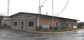 Madison Township Hall | |
 Location within Lenawee County | |
 Madison Township Location within the state of Michigan | |
| Coordinates: 41°52′02″N 84°03′14″W | |
| Country | United States |
| State | Michigan |
| County | Lenawee |
| Established | 1834 |
| Government | |
| • Supervisor | Gary Griewahn |
| • Clerk | Terry Etter |
| Area | |
| • Total | 30.9 sq mi (80.1 km2) |
| • Land | 30.7 sq mi (79.4 km2) |
| • Water | 0.2 sq mi (0.6 km2) |
| Elevation | 781 ft (238 m) |
| Population (2010) | |
| • Total | 8,621 |
| • Density | 283.7/sq mi (109.5/km2) |
| Time zone | UTC-5 (Eastern (EST)) |
| • Summer (DST) | UTC-4 (EDT) |
| ZIP code(s) | 49221 (Adrian) 49279 (Sand Creek) |
| Area code(s) | 517 |
| FIPS code | 26-50540[1] |
| GNIS feature ID | 1626662[2] |
| Website | www |
Communities
- Gorman was an unincorporated community in this township. It had a post office from 1893 until 1902.[3]
- Sand Creek is a small unincorporated community in the southwest corner of the township, located where the Stony Creek flows into the south branch of the River Raisin at 41°49′33″N 84°06′06″W.[4] The ZIP code is 49279. The area is served by Sand Creek Community Schools. The Sand Creek Aggies are members of the Tri-County Conference.
Geography
According to the United States Census Bureau, the township has a total area of 30.9 square miles (80 km2), of which 30.7 square miles (80 km2) is land and 0.2 square miles (0.52 km2) (0.78%) is water.
Demographics
As of the census[1] of 2000, there were 8,200 people, 2,191 households, and 1,676 families residing in the township. The population density was 267.4 per square mile (103.2/km2). There were 2,399 housing units at an average density of 78.2 per square mile (30.2/km2). The racial makeup of the township was 81.63% White, 13.05% African American, 0.27% Native American, 0.35% Asian, 3.33% from other races, and 1.37% from two or more races. Hispanic or Latino of any race were 7.35% of the population.
There were 2,191 households, out of which 34.7% had children under the age of 18 living with them, 61.5% were married couples living together, 11.1% had a female householder with no husband present, and 23.5% were non-families. 19.5% of all households were made up of individuals, and 7.7% had someone living alone who was 65 years of age or older. The average household size was 2.70 and the average family size was 3.07.
In the township the population was spread out, with 20.3% under the age of 18, 8.6% from 18 to 24, 38.4% from 25 to 44, 22.6% from 45 to 64, and 10.2% who were 65 years of age or older. The median age was 36 years. For every 100 females, there were 165.8 males. For every 100 females age 18 and over, there were 185.8 males.
The median income for a household in the township was $47,114, and the median income for a family was $52,642. Males had a median income of $33,941 versus $23,103 for females. The per capita income for the township was $17,749. About 1.0% of families and 2.1% of the population were below the poverty line, including 2.1% of those under age 18 and 3.1% of those age 65 or over.
References
- "U.S. Census website". United States Census Bureau. Retrieved 2008-01-31.
- U.S. Geological Survey Geographic Names Information System: Madison Charter Township, Michigan
- Walter Romig, Michigan Place Names, p. 230
- U.S. Geological Survey Geographic Names Information System: Sand Creek, Michigan
External links
- Lenawee County government site
- Complete text of History of Lenawee County published in 1909 by the Western Historical Society
Municipalities and communities of Lenawee County, Michigan, United States | ||
|---|---|---|
| Cities | 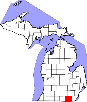 Map of Michigan highlighting Lenawee County.svg | |
| Villages | ||
| Charter townships | ||
| Civil townships | ||
| CDPs | ||
| Other unincorporated communities | ||
| Footnotes | ‡This populated place also has portions in an adjacent county or counties | |