Madang Province
Madang is a province of Papua New Guinea. The province is on the northern coast of mainland Papua New Guinea and has many of the country's highest peaks, active volcanoes and its biggest mix of languages. The capital is the town of Madang.
Madang Province | |
|---|---|
 Flag | |
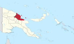 Madang Province in Papua New Guinea | |
| Coordinates: 5°10′S 145°20′E | |
| Country | Papua New Guinea |
| Capital | Madang |
| Districts | |
| Government | |
| • Governor | Jim Kas 2012- |
| Area | |
| • Total | 28,886 km2 (11,153 sq mi) |
| Population (2011 census) | |
| • Total | 493,906 |
| • Density | 17/km2 (44/sq mi) |
| Time zone | UTC+10 (AEST) |
| HDI (2018) | 0.545[1] low · 13th of 22 |
History
Human contact with the New Guinea mainland has extended through the past 50,000 years, and scientists have found evidence of human settlement 12,000 to 15,000 years ago near Simbai. In the past 6,000 years sailors ultimately originating from around Taiwan or the Malay Archipelago have traversed this area, leaving their mark in the Austronesian languages which are unevenly distributed along the coastline amongst the Papuan language villages.
The Yabob and Bilibil people used big sailing canoes to trade their pots from Karkar Island to western Morobe. They were part of the Vitiaz Strait trade network. Bundi was the centre of trade between Astrolabe Bay and the Highlands. Trade involved shells, salt, clay pots and wooden bowls from the lowlands and stone axes, feathers and women from the Asaro, Simbu and Jimi valleys.
Geography

Madang Province is a large region approximately 300 kilometres long and 160 kilometres wide with four large and many small offshore islands. The province totals 29,000 square kilometres and has a population of 365,106 (2000 census). The province shares land borders with East Sepik to the west, Enga, Western Highlands, and Jiwaka to the southwest, Chimbu and Eastern Highlands to the south, and Morobe to the southeast.
To the south lies the Bismarck Range with heights ranging over 4,000 metres. Mount Wilhelm, PNG's tallest mountain at 4509m, being found in those ranges. Also in the south, the Ramu Valley separates the Bismarck Range from the Finisterre Range to the south east of the province. The mountains are timber rich with large stands of trees and rainforest, whilst the coastal plain of the vallery is open and studded with palm trees.
The Bismarck Sea laps the northern coast of the region is fed by the larger Ramu, Sogeram, Gogol and Malas Rivers.
Offshore islands in the sea are, in some cases, volcanic, with Karkar, Bagabag and Manam being notable. In 2004/2005 the population of Manam Island was evacuated due to an eruption of the volcano. Bagabag and Karkar have had no major volcanic activities in recent years. This active volcanic region is part of the Pacific Ring of Fire and has created crater lakes, smoking volcanic cones and black sand beaches.
The Madang province receives ample rainfall (3.2 metres in Madang itself) with the months of November to June being the wettest.
People and culture
Due to changes caused by outside contact over the years, the cultural loss has been great, but isolation of many groups has caused that rate of change to be diversely uneven. Because of the environmental diversity, this province also has a very diverse culture as well. Tall, lithe coastal people from Karkar Island, short nuggety highlands men from Simbai and river people from the Ramu.
Many Madang area costumes include bamboo frames decorated with the very common cockatoo and parrot feathers as birds of paradise are relatively uncommon. The Ramu people are prolific carvers, and the lower Ramu has cultural links with the villages of the artistically diverse Sepik River region. The resurgence of cultural festivals (i.e. Maborasa Festival) has seen many people donning the dress, feathers and paints of their ancestors.
Foods eaten include those grown in fertile coastal gardens, shellfish and fish, fruit, green vegetables, bananas, taro, sweet potato and yams which relish dry soils. Sago is a staple of the Ramu river people especially in its lower reaches. The mountain people have very good gardens with excellent produce.
Languages
There are 173 regional languages spoken in Madang Province, some of them being extremely different from the others. There is a large number of very small language groups, many with fewer than 1,000 people. More than 100 Papuan languages are spoken in the province, mostly belonging to the Madang branch.
Austronesian sailors settled on this coast some 5 to 6,000 years ago and the languages of these intrepid but largely unknown sailors are found along the coast of the province, such as Lukep, Gedaged, Manam, and Bilbil. Inland, non-Austronesian Papuan languages like Katiati, Hinihon, and Saki predominate. The Ramu river languages include Gamei, Giri, Tangu, Romkun, and Igana, and the Rai Coast languages include Somau Garia and Usino. Karkar Island is unusual in that it has speakers of the Papuan language Waskia and the Austronesian language Takia.
Economy
Madang Province is PNG's third leading producer of cocoa and copra and second producer of cattle. Ramu Sugar, Coconut Oil Production Manang Ltd and Jant/Gogol woodchip mill are amongst PNG's biggest employers. Most areas are still far from transport and undeveloped. In Madang Province, 173 regional languages are spoken, some of them being extremely different from the others.
There are widespread coconut palm plantations on the coast and cardamum is grown in Madang.
The Kulili plantation is the second largest of Karkar Island's twelve plantations and has more than a thousand coconut palms and cocoa trees. These trees can grow in the same soil due to vast height differences. 70% of the cocoa and 50% of the copra produced in Madang Province comes from Karkar.
Districts and LLGs
Each province in Papua New Guinea has one or more districts, and each district has one or more Local Level Government (LLG) areas. For census purposes, the LLG areas are subdivided into wards and those into census units.[2][3][4]
Education
Madang Technical College
Madang Marine Time College
Madang Teachers College
Divine Word University (DWU) is a National University and a leading tertiary institution in Papua New Guinea. Formerly Divine Word Institute, it was established by an Act of Parliament in 1980 and was established as a University in 1996. DWU It is ecumenical, coeducational and privately governed with government support.
Provincial leaders
The province was governed by a decentralised provincial administration, headed by a Premier, from 1978 to 1995. Following reforms taking effect that year, the national government reassumed some powers, and the role of Premier was replaced by a position of Governor, to be held by the winner of the province-wide seat in the National Parliament of Papua New Guinea.[5][6]
Premiers (1978–1995)
| Premier | Term |
|---|---|
| Bato Bultin | 1978–1984 |
| Max Moeder | 1985–1986 |
| Andrew Ariako | 1986–1993 |
| provincial government suspended | 1993–1995 |
Governors (1995–present)
| Premier | Term |
|---|---|
| Peter Barter | 1995–1997 |
| Jim Kas | 1997–2000 |
| Pengau Nengo (acting) | 2000–2002 |
| Stahl Musa | 2002 |
| James Yali | 2002–2007 |
| Arnold Amet | 2007–2008 |
| Buka Malai (acting) | 2008–2009 |
| Arnold Amet | 2009–2011 |
| James Gau | 2011–2012 |
| Jim Kas | 2012–2017 |
| Peter Yama | 2017–present |
Members of the National Parliament
The province and each district is represented by a Member of the National Parliament. There is one provincial electorate and each district is an open electorate.
| Premier | Term |
|---|---|
| Madang Provincial | Peter Yama |
| Bogia Open | Robert Naguri |
| Madang Open | Bryan Jared Kramer |
| Middle Ramu Open | Jonny Alonk |
| Rai Coast Open | Peter Sapia |
| Sumkar Open | Chris Nangoi |
| Usino-Bundi Open | Jimmy Uguro |
References
| Wikivoyage has a travel guide for Madang-Morobe. |
- "Sub-national HDI - Area Database - Global Data Lab". hdi.globaldatalab.org. Retrieved 2020-04-18.
- National Statistical Office of Papua New Guinea
- "Final Figures". www.nso.gov.pg. 2011 National Population and Housing Census: Ward Population Profile. Port Moresby: National Statistical Office, Papua New Guinea. 2014.
- "Census Figures by Wards - Momase Region". www.nso.gov.pg. 2011 National Population and Housing Census: Ward Population Profile. Port Moresby: National Statistical Office, Papua New Guinea. 2014.
- May, R. J. "8. Decentralisation: Two Steps Forward, One Step Back". State and society in Papua New Guinea: the first twenty-five years. Australian National University. Retrieved 31 March 2017.
- "Provinces". rulers.org. Retrieved 31 March 2017.
| Highlands Region | |
|---|---|
| Islands Region | |
| Momase Region | |
| Southern Region | |
| |
| Bogia District | ||
|---|---|---|
| Madang District | ||
| Middle Ramu District | ||
| Rai Coast District | ||
| Sumkar District | ||
| Usino Bundi District | ||