List of lighthouses in Libya
This is a list of lighthouses in Libya, which are all located along the Mediterranean coastline of this North African country. The list includes those maritime lighthouses that are named landfall lights, or that have a range of at least twelve nautical miles. The NGA numbers are from the List of lights publication 113.[1][2]
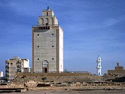
Benghazi Lighthouse
Lighthouses
| Name | Location Coordinates |
Year built |
Tower height |
Focal height |
Range nml |
NGA number |
|---|---|---|---|---|---|---|
| Al Khoms Lighthouse | Al-Khoms 32.6570056°N 14.2688340°E | n/a | 19 m (62 ft) | 26 m (85 ft) | 12 nmi (22 km) | 21636 |
| Bardia Lighthouse | Bardia 31.754337°N 25.104381°E | n/a | 12 m (39 ft) | 98 m (322 ft) | 12 nmi (22 km) | 21432 |
| Benghazi Lighthouse | Benghazi 32.12489°N 20.06361°E | 1922 | 22 m (72 ft) | 41 m (135 ft) | 17 nmi (31 km) | 21508 |
| Derna Lighthouse | Derna 32.74801°N 22.68465°E | n/a | 10 m (33 ft) | 60 m (197 ft) | 20 nmi (37 km) | 21472 |
| Farwah Lighthouse | Farwa Island Nuqat al Khams 33.10703°N 11.74345°E | n/a | 12 m (39 ft) | 17 m (56 ft) | 12 nmi (22 km) | 21728 |
| Ra's al Hallab Lighthouse | Castelverde 32.80193°N 13.80239°E | n/a | 22 m (72 ft) | 35 m (115 ft) | 12 nmi (22 km) | 21640 |
| Ra's Lanuf Lighthouse | Ra's Lanuf 30.5117°N 18.5383°E | n/a | 52 m (171 ft) | 50 m (164 ft) | 15 nmi (28 km) | 21612 |
| Ra's Tajura Lighthouse | Tajura 32.895°N 13.3867°E | n/a | 17 m (56 ft) | 34 m (112 ft) | 14 nmi (26 km) | 21644 |
| Sidi Suwaykir Lighthouse | Deriana 32.3333°N 20.2883°E | n/a | 15 m (49 ft) | 21 m (69 ft) | 13 nmi (24 km) | 21500 |
| Sirte Lighthouse | Sirte 31.2083°N 16.5933°E | n/a | 30 m (98 ft) | 35 m (115 ft) | 15 nmi (28 km) | 21624 |
| Tobruk Lighthouse | Tobruk 32.0883°N 23.99°E | n/a | 8 m (26 ft) | 53 m (174 ft) | 15 nmi (28 km) | 21452 |
| Tolmeita Lighthouse | Tolmeita 32.715°N 20.945°E | n/a | 16 m (52 ft) | 21 m (69 ft) | 12 nmi (22 km) | 21496 |
| Tripoli Lighthouse | Tripoli 32.905°N 13.1783°E | n/a | 26 m (85 ft) | 60 m (197 ft) | 12 nmi (22 km) | 21652 |
| Zuwarah Lighthouse | Zuwarah 32.925°N 12.12°E | n/a | 13 m (43 ft) | 15 m (49 ft) | 12 nmi (22 km) | 21716 |
Historic lighthouses
- Leptis Magna Lighthouse – Located in the ruins of the Roman city of Leptis Magna it was a lighthouse that was in use between 200 and 455 AD. It has been estimated that the multi-level tower once stood 35m high. A substantial part of the lower storey still remains at the site, on a headland overlooking the now silted-up harbour.[1]
See also
- List of lighthouses in Tunisia (to the west)
- List of lighthouses in Egypt (to the east)
- Lists of lighthouses and lightvessels
References
- Rowlett, Russ. "Lighthouses of Libya". The Lighthouse Directory. University of North Carolina at Chapel Hill. Retrieved 28 June 2015.
- List of Lights, Pub. 113: The West Coasts of Europe and Africa, the Mediterranean Sea, Black Sea and Azovskoye More (Sea of Azov) (PDF). List of Lights. United States National Geospatial-Intelligence Agency. 2014. p. 376.
External links
| Wikimedia Commons has media related to Lighthouses in Libya. |
Rowlett, Russ. "The Lighthouse Directory". University of North Carolina at Chapel Hill.
Lists of lighthouses in Africa | ||||||
|---|---|---|---|---|---|---|
| Sovereign states |
|  | ||||
This article is issued from Wikipedia. The text is licensed under Creative Commons - Attribution - Sharealike. Additional terms may apply for the media files.