List of islands of Papua New Guinea
This is a List of islands in Papua New Guinea, as to most of its 600 main islands, by Province listed NW to SE. [1]
_2012.png)
Numbered provinces in Papua New Guinea, referred to in the text
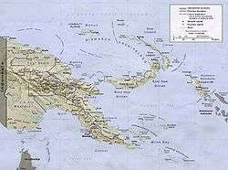
Map of Papua New Guinea
East Sepik Province
(No. 5 on the map)
- Schouten Islands, a loose group of islands off the coast of the East Sepik Province
- Tarawai (Tandanie) Island
- Walis (Walifu) Island
- Karesau Island
- Mushu Island
- Kairiru Island
- Yuo Island
- Rabuin Island
- Unei Island
- Wogeo Island
- Koil Island
- Wei (or Vial) Island
- Blupblup Island
- Kadowar Island
- Bam Island
West Sepik Province
- Tumleo Island
- Ali Island
- Seleo Island
- Angel Island
Manus Province
(No. 9 on the map)

The Admiralty Islands
- Admiralty Islands, group of 18 islands including:
- Manus Island, main island
- Los Negros Island
- Lou Island
- Ndrova Island
- Tong Island
- Baluan Island
- Pak Island
- Purdy Islands
- Rambutyo Island
- St. Andrews Islands
- Western Islands, with:
New Ireland Province
(No. 12 on the map)
- New Ireland
- New Hanover or Lavongai
- Saint Matthias Group
- Tabar Group
- Lihir Group
- Tanga Group
- Feni Islands
- Dyaul Island
West New Britain Province
(No. 18 on the map)
- New Britain or also Niu Briten, main island
- Vitu Islands
East New Britain Province
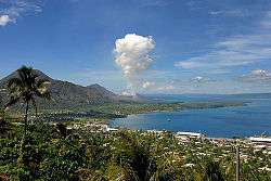
Rabaul, former capital of East New Britain province, with the Tarvurvur volcano
(No. 4 on the map)
- New Britain or also Niu Briten, main island
- Watom Island
- Matupi Island
- Duke of York Islands
Morobe Province
(No. 11 on the map)
- Umboi Island
- Tolokiwa Island
- Sakar Island
- Ritter Island
- Malai Island
- Tuam Island
Autonomous Region of Bougainville
(No. 14 on map)
Western Province
(No. 16 on map)
The islands of the Fly River Delta, including Kiwai, Purutu and Wabuda
- Daru Island
- Bristow Island
- Kawai Islands
- Kawa Island
- Karobailo Kawa Island
- Mata Kawa Island
- Parama Island
- Kiwai Island
- Purutu Island
- Wabuda Island
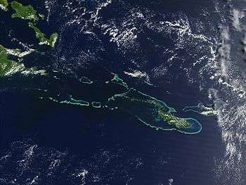
Milne Bay Province
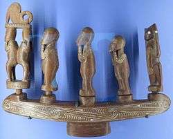
A "soul boat" from Kiriwina in the Trobriand Islands
(No. 10 on the map)
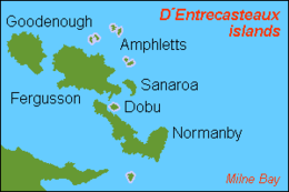
The D'Entrecasteaux Islands
- D'Entrecasteaux Islands
- Fergusson Island
- Goodenough Island
- Normanby Island (Papua New Guinea)
- Sanaroa Island
- Dobu Island
- Sori (or Wild) Island
- Woodlark Islands
- Louisiade Archipelago
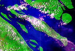
The Louisiade Archipelago
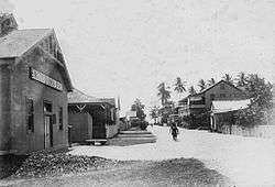
Samarai was at one time an important commercial centre. This photo is from 1906.
- Samarai Islands
- Basilaki Island
- Beika Island
- Bonarua Hili Hili Island
- Buiari Island
- Castori Islets
- Dagadaga Bonarua Island
- Deka Deka Island
- Didigilo Island
- Dinana Island
- Doini Island
- Ebuma Island
- Gado-Gadoa Island
- Galahi Island
- Gesila Island
- Gonabarabara Island
- Grant Island
- Igwali Island
- Ito Island
- Kitai Bai Island
- Kato Katoa Island
- Kitai Bona Bona Island
- Kitai Katu Island
- Kitai Lilivea Island
- Kui Island
- Kwai Ama Island
- Kwato Island
- Lesimano Island
- Logea Island
- Nasariri Island
- Populai Island
- Samarai
- Sariba Island
- Sideia Island
- Sripkunui Island
- Tuyam Island
- Wasima Island
- Bentley Islands
- Bonvouloir Islands
- Calvados Chain
- Panasia
- Sloss Islands
- Utian Island
- Pana Rora Island
- Pana Udu Udi
- Gulewa Island
- Ululina Island
- Venariwa Island
- Motorina
- Bonna Wan
- Bagaman Island
- Bobo Eina Island
- Pana Numara
- Yaruman
- Panangaribu
- Panatinane Island
- Kuwanak Island
- Gigila
- Pana Wina Island
- Hemenahei Island
- Conflict Group
- Auriroa Island
- Gabugabutau Island
- Ginara Island
- Irai Island
- Itamarina Island
- Lunn Island
- Moniara Island
- Panaboal Island
- Panarakuum Island
- Panasesa Island
- Quesal Island
- Tupit Island
- Deboyne Islands
- Losai Island; Nibub Island; Nivani Island
- Pana Uya Wana; Panaeati; Panapompom
- Passage Island
- Rara Island
- Duchateau Islands
- Jomard Islands
- Kukuluba Island
- Montemont Islands
- Pana Bobai Ana
- Pana Rura Wara
- Dumoulin Islands
- Ana Karu Karua
- Baiiri
- Duperre Islands
- Duperre Island
- Punawan
- East Deboyne Islands
- Basses Group; Bushy Islets; Mabui Island
- Pana Sagasagu; Redlick Islets
- Engineer Islands
- Bright Island; Butchart Island; Button Island
- Deedes Island; Flat Island; Good Island; Haszard Island
- Hummock Island
- Messum Island; Pender Island; Powell Island
- Skelton Island; Slade Island; Watts Island
- Laseinie Islands
- Dawson Island, Kagawan Island; Keaawan Island
- Hardman Islands
- Misima Island
- Daloloia Group
- Pana Tinani Islands
- Nimoa Island
- Pana Tinani
- Wanim Island
- Yeina Island
- Daddahai Island; Hevaisi Island; Osasai Island; Sibumbum Island
- Renard Islands
- Baiwa; Kimuta; Manuga Reef; Oreia
- Rossel Islands
- Torlesse Islands
- Pananiu Island
- Tinolan
- Vanatinai Islands
- Boboa Island
- Iyen Island
- Tagula Island also known as Vanatinai Island and Sudest Island
- Venama
- Wari Islands
- Imbert Island
- Kosman Reef
- Lebrun Islands
- Long Island
- Quessant Island
- Sable Island
- Siga Island
- Stuers Islands
- Wari Island
- Samarai Islands
References
- "Papua New Guinea". The Commonwealth. Retrieved 17 May 2019.
Papua New Guinea articles | |||||
|---|---|---|---|---|---|
| History |  | ||||
| Geography | |||||
| Politics | |||||
| Economy |
| ||||
| Society |
| ||||
| |||||
This article is issued from Wikipedia. The text is licensed under Creative Commons - Attribution - Sharealike. Additional terms may apply for the media files.