List of districts of Seoul
The Districts (Gu) of Seoul are the twenty-five gu ("districts"; 구; 區) comprising Seoul, South Korea. The gu vary greatly in area (from 10 to 47 km²) and population (from less than 140,000 to 630,000). Songpa is the most populated, while Seocho has the largest area. Gu are similar to London's or New York's boroughs or Tokyo's 23 special wards, and a gu's government handles many of the functions that are handled by city governments in other jurisdictions. This city-like standing is underscored by the fact that each gu has its own legislative council, mayor and sister cities. Each gu is further divided into dong or neighborhoods. Some gu have only a few dong while others (like Jongno-gu) have a very large number of distinct neighborhoods.
| Provincial-level subdivisions of South Korea |
|---|
| Provinces |
| North Chungcheong |
| South Chungcheong |
| Gangwon |
| Gyeonggi |
| North Gyeongsang |
| South Gyeongsang |
| Jeju |
| North Jeolla |
| South Jeolla |
| Cities |
| Busan |
| Daegu |
| Daejeon |
| Gwangju |
| Incheon |
| Sejong |
| Seoul |
| Ulsan |
List by population and area
2014 estimate by Seoul Statistics.[1][2][3]
| Name | Population | Area | Population density |
|---|---|---|---|
| Dobong-gu (도봉구; 道峰區) | 355,712 | 20.70 km² | 17184/km² |
| Dongdaemun-gu (동대문구; 東大門區) | 376,319 | 14.21 km² | 26483/km² |
| Dongjak-gu (동작구; 銅雀區) | 419,261 | 16.35 km² | 25643/km² |
| Eunpyeong-gu (은평구; 恩平區) | 503,243 | 29.70 km² | 16944/km² |
| Gangbuk-gu (강북구; 江北區) | 338,410 | 23.60 km² | 14339/km² |
| Gangdong-gu (강동구; 江東區) | 481,332 | 24.59 km² | 19574/km² |
| Gangnam-gu (강남구; 江南區) | 583,446 | 39.50 km² | 14771/km² |
| Gangseo-gu (강서구; 江西區) | 591,653 | 41.43 km² | 14281/km² |
| Geumcheon-gu (금천구; 衿川區) | 258,030 | 13.02 km² | 19818/km² |
| Guro-gu (구로구; 九老區) | 457,131 | 20.12 km² | 22720/km² |
| Gwanak-gu (관악구; 冠岳區) | 531,960 | 29.57 km² | 17990/km² |
| Gwangjin-gu (광진구; 廣津區) | 377,375 | 17.06 km² | 22120/km² |
| Jongno-gu (종로구; 鍾路區) | 165,344 | 23.91 km² | 6915/km² |
| Jung-gu (중구; 中區) | 136,227 | 9.96 km² | 13677/km² |
| Jungnang-gu (중랑구; 中浪區) | 423,411 | 18.50 km² | 22887/km² |
| Mapo-gu (마포구; 麻浦區) | 395,830 | 23.84 km² | 16604/km² |
| Nowon-gu (노원구; 蘆原區) | 586,056 | 35.44 km² | 16536/km² |
| Seocho-gu (서초구; 瑞草區) | 454,288 | 47.00 km² | 9666/km² |
| Seodaemun-gu (서대문구; 西大門區) | 320,861 | 17.61 km² | 18220/km² |
| Seongbuk-gu (성북구; 城北區) | 475,961 | 24.58 km² | 19364/km² |
| Seongdong-gu (성동구; 城東區) | 303,891 | 16.86 km² | 19364/km² |
| Songpa-gu (송파구; 松坡區) | 671,794 | 33.88 km² | 19829/km² |
| Yangcheon-gu (양천구; 陽川區) | 490,708 | 17.40 km² | 28202/km² |
| Yeongdeungpo-gu (영등포구; 永登浦區) | 421,436 | 24.53 km² | 17180/km² |
| Yongsan-gu (용산구; 龍山區) | 249,914 | 21.87 km² | 11427/km² |
| Seoul (서울) | 10,369,593 | 605.21 km² | 17134/km² |
General information
| Name | Dong | General Information | Points of Interest | Image | Location |
|---|---|---|---|---|---|
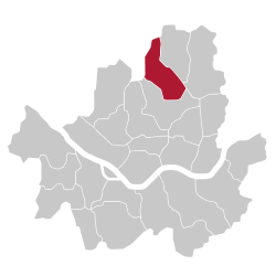
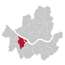
| Dobong-gu | Located in the northeastern part of the city, Dobong is a largely residential district, which has been part of Seoul since 1963. Located next to its namesake Dobongsan, the district is expected to benefit from urban development projects near Chang-dong station. |  |
 | ||
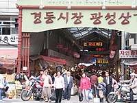
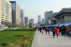
| Dongdaemun-gu | Despite its name (Large East Gate), Dongdaemun district does not include the East gate of Seoul, also known as Dongdaemun (and by its official name Heunginjimun). Incorportated into Seoul in 1936, the heart of the district is Cheongnyangni station, one of the main train stations in Seoul, built in 1911. |
|
 |
 | |
| Dongjak-gu | Located just south of the Han river, Dongjak-gu is mostly residential, but also includes the commercial Noryangjin area. The small Seodalsan mountain, where the Seoul National Cemetery is located, is located in the middle of the district. |
|
 |
 | |
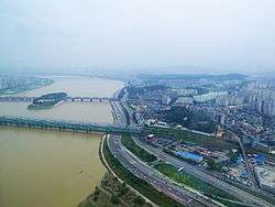
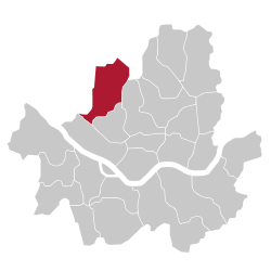
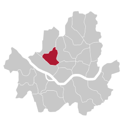
| Eunpyeong-gu | Separated administratively from Seodaemun-gu in 1977, Eunpyeong-gu is located just east of the city of Goyang, and despite being part of Seoul, is partly isolated from the rest of the city by a mountain range on its east side. |
|
 |
 | |
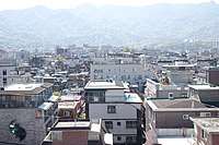
| Gangbuk-gu | Incorporated into Seoul in 1949, Gangbuk-gu is a separate district (from Seongbuk-gu) since 1995. The district is notorious for its proximity with Bukhansan, the tallest mountain near Seoul. The district is mostly residential, although the areas near Miasageori station and Suyu station are very active. |
|
 |
 | |
| Gangdong-gu |
|
 |
 | ||
| Gangnam-gu |
|
|
 |
 | |
| Gangseo-gu |
|
|
 |
 | |
| Geumcheon-gu |  |
 | |||
| Guro-gu |
|
 |
 | ||
| Gwanak-gu | Incorporated in 1963, and designated as a distinct district in 1973, Gwanak district is mostly residential, and gets its name from the nearby Gwanaksan mountain. Korea's best university, Seoul National University, is located in the district. |  |
 | ||
| Gwangjin-gu |
|
 |
 | ||
| Jongno-gu |
|
 |
 | ||
| Jung-gu | Not subdivided into dongs |  |
 | ||
| Jungnang-gu |
|
 |
 | ||
| Mapo-gu |
|
|
 |
 | |
| Nowon-gu | Located between Mount Buramsan and Mount Suraksan to the East, and the Jungnangcheon stream to the West, Nowon district is mostly a residential district, which is also known for its many universities, including Seoul National University of Science and Technology, Kwangwoon University or Seoul Women's University. |
|
 |
 | |
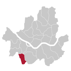
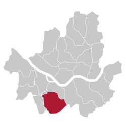
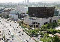
| Seocho-gu | Seoul's largest district is part of the "greater Gangnam" and is one of the busiest areas in Seoul, especially on the eastern part of the district. Seoul's largest bus terminal, Seoul Express Bus Terminal is located in the affluent Banpo-dong. However, Seocho's southern half is barely populated as it is mostly mountaineous. |  |
 | ||
| Seodaemun-gu | A heclectic district, center around Mount Ansan. The east part of the district is part of the historic downtown, while the southern part includes the university district of Ehwa University and Yonsei University. The Seodaemun prison and Independence Park are some of the most famous landmarks in Seodaemun. |
|
 |
 | |
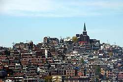
| Seongbuk-gu | Long-inhabited, Seongbuk district it located just North-East of the city center. The prestigious Korea University is located in the South of the district. While the majority of the district is made up for middle-class residential areas, the district is noted for the gap between the slum-like Bukjeong village, and the expensive residences of Seongbuk-dong. |  |
 | ||
| Seongdong-gu | A diverse district located just East of the historical city center, Seongdong is mostly a middle-class residential neighborhood. At its center is Wangsimni Station a major subway and train station. On the southern end of the district is located Seoul Forest and the nearby Seongsu-dong, an historically manufacturing neighborhood which is currently being gentrified. |
|
 |
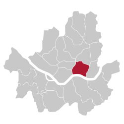 | |
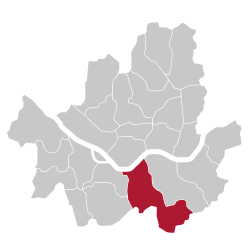
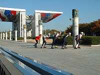
| Songpa-gu | The Songpa district, mostly developed during the 1980s, is today the most populated in Seoul. Famous for its sprawling apartment complexes, it hosted most of the competitions during the 1988 Summer Olympics at the Seoul Sports Complex and the Olympic Park. Lotte World Tower, the world's fifrth tallest building, is located in the Jamsil neighborhood of the district. |
|
 |
 | |
| Yangcheon-gu |
|
Located South of the Han River and on the Western part of time, Yangcheon is a mostly residential district, and is amongst the smallest in Seoul. The Mokdong area is famous for its expensive apartment complexes and private educational institutions, as well as its sports complex. |
|
 |
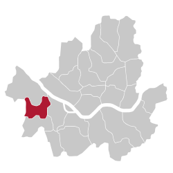 |
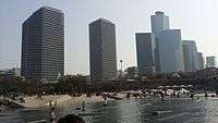
| Yeongdeungpo-gu | Located in the South-West part of the city, Yeongdeungpo is home to a large Chinese community. Yeouido, a large island which is home to the National Assembly of Korea and to the city's financial district and many of its tallest skyscrapers, is also part of Yeongdeungpo. |
|
 |
 | |
| Yongsan-gu | Geographically located in the center of Seoul, Yongsan is known for Mount Namsan, and the Yongsan Garrison. A cosmopolitan district, it includes Itaewon and the Ichon Japanese Village. Yongsan Station, a major train station, is also located in the district. |
|
 |
 |
See also
- Administrative Divisions of South Korea
- Districts of South Korea
- Special wards of Tokyo
- Boroughs of New York City
- London borough
- Arrondissements of Paris
- Municipalities of the Brussels-Capital Region
References
- "Area and Number of Administrative Units". Seoul Statistics. Retrieved October 13, 2015.
- "Administrative areas". Seoul Statistics. Retrieved October 13, 2015.
- "Seoul Metropolitan City". citypopulation.de. Retrieved October 13, 2015.
| Districts |
|  | ||||
|---|---|---|---|---|---|---|
| Neighbourhoods |
| |||||