List of Indiana state historical markers in St. Joseph County
This is a list of the Indiana state historical markers in St. Joseph County.
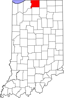
Location of St. Joseph County in Indiana
This is intended to be a complete list of the official state historical markers placed in St. Joseph County, Indiana, United States by the Indiana Historical Bureau. The locations of the historical markers and their latitude and longitude coordinates are included below when available, along with their names, years of placement, and topics as recorded by the Historical Bureau. There are 18 historical markers located in St. Joseph County.[1]
Historical markers
| Marker title | Image | Year placed | Location | Topics |
|---|---|---|---|---|
| La Salle's Camp 1 Mile West[2] | ? | Junction of the Dixie Highway (State Road 933) and Darden Road near South Bend 41°43′48.8″N 86°15′1.4″W |
Early Settlement and Exploration | |
| Camp Rose[3] | 1963 | Junction of Leland and Portage Avenues in South Bend 41°41′4″N 86°15′29.7″W |
Military | |
| Sisters of the Holy Cross, Civil War Nurses, 1861-1865[4] | 1965 | Junction of E. Madison Street and N. Notre Dame Avenue in South Bend 41°40′49.4″N 86°14′19″W |
Women, Military, Religion | |
| Indiana Territorial Line (east-west boundary at this point)[5] | 1966 | Junction of U.S. Route 31 and Johnson Road on the southern edge of South Bend 41°37′1″N 86°15′7″W |
Early Settlement and Exploration, Government Institutions | |
| Site of Home of Schuyler Colfax March 23, 1823-January 1, 1885[6] | 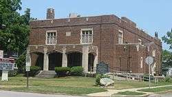 |
1966 | Junction of Colfax and Taylor Streets in South Bend 41°40′40″N 86°15′28.5″W |
Politics, Newspapers and Media |
| First Dam Across the St. Joseph River/Power Race[7] | 1968 | Junction of Race and First Streets in Mishawaka 41°39′46″N 86°10′42″W |
Business, Industry, and Labor | |
| First Bridge[8] | 1968 | 300 block of N. Main Street at the St. Joseph River in Mishawaka 41°39′50″N 86°10′52″W |
Transportation, Buildings and Architecture | |
| The Mishawaka Academic and Normal Institute 1846-1868[9] | 1968 | 303 S. Main at 4th Street in Mishawaka 41°39′32″N 86°10′50.7″W |
Education | |
| St. Joseph Iron Works[10] | 1968 | 300 block of N. Main Street in Mishawaka 41°39′46″N 86°10′49.6″W |
Business, Industry, and Labor | |
| Mishawaka High School[11] |  |
1976 | Mishawaka High School at 1202 Lincoln Way E. in Mishawaka 41°39′45″N 86°9′39″W |
Education |
| Kamm & Schellinger Brewery[12] | 1995 | 100 Center Street Complex at Lincoln Way on the southern bank of the St. Joseph River in Mishawaka 41°39′45″N 86°11′22″W |
Business, Industry, and Labor | |
| Normain Heights Subdivision[13] | 1997 | Lawn of the fire station at 2332 N. Main Street in Mishawaka 41°40′53.6″N 86°10′52.4″W |
Military, Historic District, Neighborhoods, and Towns | |
| Battell Park[14] | 1997 | 400 W. Mishawaka Avenue at the Charlotte Avenue junction in Mishawaka 41°39′58″N 86°11′16″W |
Nature and Natural Disasters, Buildings and Architecture | |
| Huggart Settlement[15] | 1998 | Northwestern corner of the junction of State Road 4 and Mulberry Road east of Potato Creek State Park in Union Township 41°32′7″N 86°18′44″W |
African American | |
| Dodge Manufacturing Company[16] | 1999 | 500 S. Union Street at the parking lot and entrance to the RMG foundry of the Troyer Group in Mishawaka 41°39′23.2″N 86°10′37″W |
Business, Industry, and Labor | |
| Jewish Cemetery Site[17] | 2002 | Western side of the 500 block of N. Niles Avenue in South Bend 41°40′57.4″N 86°14′40.6″W |
Cemetery, Immigration and Ethnic Groups | |
| Porter (Rea) Cemetery[18] | 2003 | Cemetery located in Potato Creek State Park near North Liberty 41°32′56″N 86°21′10″W |
Cemetery, African American | |
| Lincoln & Dixie Highways[19] | 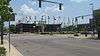 |
2010 | South Bend 41°40′34.5″N 86°15′1.6″W |
Cemetery, African American |
See also
References
- "Indiana Historical Markers by County". State of Indiana. Retrieved 2012-03-15.
- La Salle's Camp 1 Mile West, Indiana Historical Bureau, n.d. Accessed 2012-03-14.
- Camp Rose, Indiana Historical Bureau, n.d. Accessed 2012-03-14.
- Sisters of the Holy Cross, Civil War Nurses, 1861-1865, Indiana Historical Bureau, n.d. Accessed 2012-03-14.
- Indiana Territorial Line (east-west boundary at this point), Indiana Historical Bureau, n.d. Accessed 2012-03-14.
- Site of Home of Schuyler Colfax March 23, 1823-January 1, 1885, Indiana Historical Bureau, n.d. Accessed 2012-03-14.
- First Dam Across the St. Joseph River/Power Race, Indiana Historical Bureau, n.d. Accessed 2012-03-14.
- First Bridge, Indiana Historical Bureau, n.d. Accessed 2012-03-14.
- The Mishawaka Academic and Normal Institute 1846-1868, Indiana Historical Bureau, n.d. Accessed 2012-03-14.
- St. Joseph Iron Works, Indiana Historical Bureau, n.d. Accessed 2012-03-14.
- Mishawaka High School, Indiana Historical Bureau, n.d. Accessed 2012-03-14.
- Kamm & Schellinger Brewery, Indiana Historical Bureau, n.d. Accessed 2012-03-14.
- Normain Heights Subdivision, Indiana Historical Bureau, n.d. Accessed 2012-03-14.
- Battell Park, Indiana Historical Bureau, n.d. Accessed 2012-03-14.
- Huggart Settlement, Indiana Historical Bureau, n.d. Accessed 2012-03-14.
- Dodge Manufacturing Company, Indiana Historical Bureau, n.d. Accessed 2012-03-14.
- Jewish Cemetery Site, Indiana Historical Bureau, n.d. Accessed 2012-03-14.
- Porter (Rea) Cemetery, Indiana Historical Bureau, n.d. Accessed 2012-03-14.
- Lincoln & Dixie Highways, Indiana Historical Bureau, n.d. Accessed 2012-07-14.
External links
Municipalities and communities of St. Joseph County, Indiana, United States | ||
|---|---|---|
| Cities | Map of Indiana highlighting St. Joseph County | |
| Towns | ||
| Townships | ||
| CDPs | ||
| Unincorporated communities | ||
| Footnotes | ‡This populated place also has portions in an adjacent county or counties | |
This article is issued from Wikipedia. The text is licensed under Creative Commons - Attribution - Sharealike. Additional terms may apply for the media files.