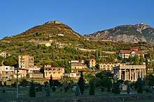
Lezhë
Lezhë (Albanian: Lezha or Lezhë, Albanian pronunciation: [ˈlɛʒə]) is a town and municipality in northwest Albania, in the county with the same name.
Lezhë | |
|---|---|
    Lezhë photomontage | |
 Emblem | |
 Lezhë | |
| Coordinates: 41°47′N 19°38′E | |
| Country | |
| County | Lezhë |
| Government | |
| • Mayor | Pjerin Ndreu (PS) |
| Area | |
| • Municipality | 514.97 km2 (198.83 sq mi) |
| Elevation | 10 m (30 ft) |
| Population (2011) | |
| • Municipality | 65,633 |
| • Municipality density | 130/km2 (330/sq mi) |
| • Municipal unit | 15,510 |
| Time zone | UTC+1 (CET) |
| • Summer (DST) | UTC+2 (CEST) |
| Postal Code | 4501-4502 |
| Area Code | (0)215 |
| Vehicle registration | AL |
| Website | Official Website |
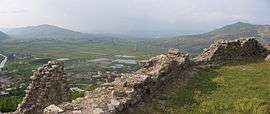
One of the main strongholds of the Labeatai,[1] the earliest of the fortification walls of the city are of typical Illyrian construction and are dated to the late 4th century BC.[2] The city was one of the main centres of the Illyrian kingdom.[3] During the conflicts with Macedon it was captured by Philip V becoming the Macedonian outlet to the Adriatic sea.[4] The town was later recovered by the Illyrians. It was subjected to Rome after the Roman-Illyrian wars and the fall of Gentius' realm.[3]
The present municipality was formed at the 2015 local government reform by the merger of the former municipalities Balldren, Blinisht, Dajç, Kallmet, Kolsh, Lezhë, Shëngjin, Shënkoll, Ungrej and Zejmen, that became municipal units. The seat of the municipality is the town Lezhë.[5] The total population is 65,633 (2011 census),[6] in a total area of 514.97 square kilometres (199 square miles).[7] The population of the former municipality at the 2011 census was 15,510.[6]
Name
The City is mentioned in ancient sources as Lissos (Ancient Greek: Λισσός) and Lissus (Latin: Lissus).[8] The ancient name Lissus evolved into its modern form Lezhë (archaic: Lesh[8]) through Albanian sound changes.[9] In Turkish, the town is known as Leş or Eşim and in Italian as Alessio. Lezhë is also known as Alise, Alexiensis, Eschenderari, or Mrtav.[10]
History
Prehistory
From the early Mycenaean period (1600-1450 BC) a free exchange pattern is confirmed with the centres of Mycenaean Greece as seen by various swords (C and D type) unearthed in Lezhë.[12] The earliest human constructions have an Illyrian character and appear on the site from the Late Bronze Age and Early Iron Age.[13] The settlement with its fortifications was built on a 413 m high mountain, the Mal i Shëlbuemit, from at least the 8th century BC,[14] and was located near the mouth of the Drin river.[15]
Classical antiquity

In antiquity the area was described as the territory of the Illyrii tribe (the "Illyrians proper"; Ancient Greek: Ἰλλυριοί, Illyrioi; Latin: Illyrii or Illyrii propriae dicti).[16]
Diodorus ("Library", 15.1, c. 1st century BC) mentions that Dionysius of Syracuse founded a "city named Lissus" in the year 385 BC,[17] as part of a strategy by Dionysius to secure Syracusan trade routes along the Adriatic.[18] Diodorus calls it a polis.[17] According to some scholars, the Syracusan colony mentioned by Diodorus was established at Issa near the island of Pharos, not at Lissus (modern Lezhë) which was too distant for the events described by the ancient historian.[19][20] According to Gocha Tsetskhladze, there is nothing to connect Lissos with Syracuse except Diodorus' account, and even if Diodorus' account is accepted as accurate, it is very likely that this colony had a short life.[19]
The earliest of the fortification walls of the proto-urban settlement are of typical Illyrian construction and are dated to the late 4th century BC.[21] The transition from the Iron Age fortification of Acrolissus (on the 413 m Shëlbuem mountain) to the proper Illyrian city of Lissus was continuous. The city was built on a lower hill (172 m) near the Iron Age fortification.[22] It was surrounded by ramparts that faced the low valley of the Drin river and the sea coast. Its function was to guard the route inland, to ensure defense against possible attacks from the sea, and to furnish a secure anchorage for the Illyrian ships.[23]
By the 3rd century BC, Lissus was one of the main cities of the Illyrian kingdom under the Ardiaean and Labeatan dynasties.[3] In the 228 BC peace treaty with Rome, the Illyrian queen Teuta promised not to sail south of Lissus at the mouth of the Drin river with more than two lembi (Illyrian light ships), even those had to be unarmed.[24] But when Rome was engaged in a war against the Celtic peoples of the Po Valley in northern Italy about the years 225–222 BC, Illyrian commander Demetrius detached the Atintani tribe from their alliance with Rome. Moreover, he sailed south of Lissus and engaged in piracy in violation of the 228 BC peace treaty. In the summer of 221 BC, tensions in Greece increased as Macedonia allied with the Achaean League against the Aetolian League, and the Illyrians attacked in their typical manner. Demetrius and Scerdilaidas sailed with 90 lembi south of Lissus. When they failed an assault on Pylos (western Peloponnese), they separated their fleets and Scerdilaidas returned north with 40 ships, while Demetrius plundered the Cyclades with 50 ships.[25]
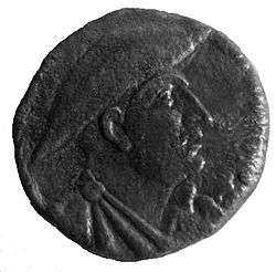
In Roman times Lissus was located in a territory inhabited by the Labeatae, however ancient sources never relate it with this tribe. Taking in account archaeological and historical considerations, the city of Lissus should have been founded in a Labeatan context, but perhaps by the time of Teuta's fall in the end of the 3rd century BC, it was organized as a proper polis turning away from it's ethnic context. The dissociation from the ethnic to the polis coincided with Philip V of Macedon's conquest of a number of cities in Illyria.[26] In 211 BC, Philip V captured Acrolissus, the citadel of Lissus, and Lissos surrendered to him,[27] becoming the Macedonian outlet to the Adriatic sea.[19] The town was later recovered by the Illyrians. It was in Lissus that Perseus of Macedon negotiated an alliance against Rome with the Illyrian king Gentius, and it was from Lissus that Gentius organized his army against the Romans. Lissus maintained a large degree of municipal autonomy under both Macedonian and Illyrian rule, as evidenced by the coins minted there.[28] During the reign of Gentius in the first half of the 2nd century BC, Lissus minted coins for the Illyrian ruler.[29] The city was of some importance in the Roman Civil War, being taken by Marc Antony [30] and then remaining loyal to Caesar. In Roman times, the city was part of the province of Epirus Nova,[31]
Middle Ages and Ottoman period
During the reign of Justinian I (527-565) the local fortress was possibly mentioned as Alistion in the Synecdemus of Hierocles.[32] At early 590s Lissus was captured by Slavic populations.[33] Byzantine control was re-established during the early 9th century.[34]

In Middle Ages Lezha (known in Italian as Alessio) frequently changed masters until the Venetians took possession of it in 1386. It still belonged to them when Skanderbeg died, but In 1478 it fell into the hands of Turks during the siege of Shkodra, with the exception of a short period (1501–1506) when it returned to Venetian domination.[10] Because it was under the Venetian control, it was chosen in 1444 by George Castrioti (Skanderbeg) as a neutral place for the convention of Albanian, Serbian, Dalmatian and other lords of the area aiming at organizing their common defence against the Turks.[35]
Lezha was the site of the League of Lezhë where Skanderbeg united the Albanian princes in the fight against the Ottoman Empire.
Skanderbeg was buried in the cathedral of Lezhë which was dedicated to Saint Nicholas and later used as Selimie Mosque.
Modern era
Today Lezhë is a growing city. Its proximity to the port of Shëngjin as well as its location on the national road between the Montenegrin border to the North and Tirana to the South makes it an attractive location for industry and business.
Majority of the people from Lezhë descend from the Zadrima, Mirdita and Malësia/Malësi e madhe regions of northwestern Albania. The people from Zadrima and Mirdita are native to Lezhë and the surrounding area. Whilst the Malësor clans from Malësia, such as Kelmendi, Shkreli, Kastrati etc., had settled Lezhë and surrounding areas around 100–300 years ago. In terms of religion, Lezha has a Catholic majority(70-80%) and a Muslim minority(30-20%)
Sights

Transportation

Bus
There are urban buses throughout the city and international and national buses.
Trains
Lezhe has a train station not far from the center. The line starts in Durrës and ends in Shkodër. It is functonally but not frequently.
Highways
The main highway in Lezhe is E762. The E762 stars in Fushë-Krujë and ends in Shkodër. The Durrës-Kukës Highway intersects with E762 in Milot. Also the SH32 intersects in to Lezhe coming from Shëngjin.
Sport
The association football club is KS Besëlidhja Lezhë. Although primarily concerned with football, KS Besëlidhja also participates in sports such as wrestling and beach volleyball.
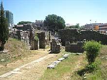
Archaeological excavations
From 2004 an excavation started around the ancient Acropolis of Lissos and the Skanderbeg Memorial, which revealed Hellenistic, Roman and Early Byzantine buildings, tombs and other findings.[36]
Notable people
- Skanderbeg, the National Hero of Albania
- Anton Kryezezi, Bishop of Lezhë
- Lekë Dukagjini, prince
- Jonima (Gjoni) family noble family
- Gjergj Fishta, Catholic priest and poet
- Ndoc Gjetja, poet
- Henri Ndreka, soccer player, capped with Albania
- Robert Grizha, soccer player
- Erjon Dushku, soccer player
- Renato Malota, soccer player
- Ornel Gega, rugby union player
See also
- 2010 Albania floods
- Drin River
- Fort Mosque
- Fushë-Kuqë
- Lezhë Castle
- List of ancient cities in Illyria
- List of mayors of Lezhë
- Mirditë District
- Shëngjin
- Roman Catholic Diocese of Lezhë
- Zadrima
- lezhe mosque
References
Notes
Citations
- Waterfield 2014, p. 49.
- Stylianou 1998, p. 194.
- Shehi 2015, p. 34.
- Tsetskhladze 2008, p. 177; Shehi 2015, p. 34
- Law nr. 115/2014 Archived 2015-09-24 at the Wayback Machine
- "Population and housing census - Lezhë 2011" (PDF). INSTAT. Retrieved 2019-09-25.
- "Correspondence table LAU – NUTS 2016, EU-28 and EFTA / available Candidate Countries" (XLS). Eurostat. Retrieved 2019-09-25.
- Gaffiot 1934, p. 915: "Lissus".
- Katičić 1976, p. 186.
- Catholic Encyclopedia, article "Alessio (Lissus, Alexiensis)"
- Shpuza 2014, p. 118; Shehi 2015, p. 34
- Bejko, Lorenc (2002). "Mycenaean Presence and Influence in Albania". Greek influence along the East Adriatic Coast. Kniževni Krug: 12. Retrieved 4 April 2020.
The variety of C and D type swords reported from central and northern Albania (Mat river valley, Lezhë, Shkodër), and their provenience from burial contexts, confirm the free exchange pattern with the Mycenaean centers of this part of the country, as in the early Mycenaean period.
- Shpuza 2014, pp. 106, 116, 118: "All the sites described above are situated in the Lowlands of Shkodra, in small hills, which create a protection system of all the area. A similar fortification can be found also at Akrolissos, [...] The chronological framework for the dating of such fortifications is the Final Bronze Age and the Early Iron Age."
- Elsie 2010, p. 272.
- Wilkes 1992, p. 135; Tsetskhladze 2008, p. 177
- Matijašić 2011, p. 299; Boardman & Sollberger 1982, pp. 628–629
- Mogens Herman Hansen (2004). An Inventory of Archaic and Classical Poleis. Oxford University Press. p. 322. ISBN 0-19-814099-1.
Lissos was founded shortly before 385 by Dionysios I [...] on the steep slope of a hill, modern Lezha [...] a site already occupied by Illyrian settlers.
- Evans, A., Destani, B., Ancient Illyria, an archeological exploration. IB Tauris, 2007. p. 276.
- Tsetskhladze 2008, p. 177.
- Wilkes 1992, p. 115: "It has been proposed that it was this place [Issa] and not Lissus far to the south at the mouth of the Drin from which help came to the Greeks on Pharos, since Issa lies only 25 miles away."
- Wilkes 1992, p. 135; Tsetskhladze 2008, p. 177; Stylianou 1998, p. 194; Shehi 2015, p. 34
- Shpuza 2014, p. 118; Shehi 2015, p. 34
- Wilkes 1992, p. 135; Tsetskhladze 2008, p. 177
- Wilkes 1992, p. 161–162; Errington 1989, pp. 89–90
- Wilkes 1992, p. 162–163; Errington 1989, pp. 91–92
- Shpuza 2017, p. 43.
- Polybius 8.13-14
- Arthur Evans (2007). Ancient Illyria: An Archaeological Exploration. I.B.Tauris. p. 276. ISBN 9781845111670.
- Shpuza 2014, p. 122.
- Plutarch (1920). Life of Antony. Loeb Classical Edition. p. 7.4.
- Epirus Vetus: The Archaeology of a Late Antique Province (Duckworth Archaeology) by William Bowden, 2003, ISBN 0-7156-3116-0,2003, page 233, of Lissus in Epirus Nova
- Winnifrith, Tom (2002). Badlands, Borderlands: A History of Northern Epirus/Southern Albania. Duckworth. p. 75. ISBN 978-0-7156-3201-7.
Also for Justinian's reign there survives a catalogue of towns in the Empire, the Synecdemus of Hierocles." "In Epirus Nova we find Apollonia, Byllis, Amantia, Pulcheropolis (Berat), Aulon (Vlore), Lychnidus (Ohrid) and the unknown Alistion, possible the modern Lezhe, and Skepton
- Pohl, Walter (2018). The Avars: A Steppe Empire in Central Europe, 567–822. Cornell University Press. p. 149. ISBN 978-1-5017-2940-9.
- Curta, Florin (2019). Eastern Europe in the Middle Ages (500-1300) (2 vols). BRILL. p. 308. ISBN 978-90-04-39519-0.
The fortress in Lezhe farther to the north along the coast of the Adriatic Sea, was reoccupied in the early 9th century
- Schmitt Jens O.(2009) Skanderbeg, Der neue Alexander auf dem Balkan, Verlag Friedrich Pustet, pp. 55,56
- Karl-Franzens Universitat, Lissus excavation report 2004. Archived 2011-06-29 at the Wayback Machine
Bibliography
- Beekes, Robert S. P. (2009). Beek, Lucien van (ed.). Etymological Dictionary of Greek. Brill. ISBN 978-90-04-32186-1.CS1 maint: ref=harv (link)
- Boardman, John; Sollberger, E. (1982). J. Boardman; I. E. S. Edwards; N. G. L. Hammond; E. Sollberger (eds.). The Cambridge Ancient History: The Prehistory of the Balkans; and the Middle East and the Aegean world, tenth to eighth centuries B.C. III (part 1) (2 ed.). Cambridge University Press. ISBN 0521224969.CS1 maint: ref=harv (link)
- Errington, R. M. (1989). "Rome and Greece to 250 B.C.". In A. E. Astin; F. W. Walbank; M. W. Frederiksen; R. M. Ogilvie (eds.). The Cambridge Ancient History: Rome and the Mediterranean to 133 B.C. VIII (2 ed.). Cambridge University Press. pp. 81–106. ISBN 0-521-23448-4.CS1 maint: ref=harv (link)
- Eckstein, Arthur M. (2008). Rome Enters the Greek East: From Anarchy to Hierarchy in the Hellenistic Mediterranean, 230-170 B.C. Malden, MA.; Oxford: Blackwell Publishing.CS1 maint: ref=harv (link)
- Elsie, Robert (2010). Historical Dictionary of Albania (PDF). Historical Dictionaries of Europe. 75 (2 ed.). Scarecrow Press. p. 255. ISBN 978-0810861886. Archived from the original (PDF) on 6 October 2014.CS1 maint: ref=harv (link)
- Gaffiot, Félix (1934). Dictionnaire Illustré Latin-Français. Hachette.CS1 maint: ref=harv (link)
- Hammond, Nicholas Geoffrey Lemprière (1966). "The Kingdoms in Illyria circa 400-167 B.C.". The Annual of the British School at Athens. British School at Athens. 61: 239–253. JSTOR 30103175.CS1 maint: ref=harv (link)
- Katičić, Radoslav (1976). Ancient Languages of the Balkans. Mouton. ISBN 978-9027933058.CS1 maint: ref=harv (link)
- Matijašić, Ivan (2011). ""Shrieking like Illyrians": Historical geography and the Greek perspective of the Illyrian world in the 5th century BC". Arheološki vestnik. 62: 289–316.CS1 maint: ref=harv (link)
- Shehi, Eduard (2015). Terra sigillata en Illyrie méridionale et en Chaonie: importations et productions locales (IIe S. AV. J.-C. -IIe S. AP. J.-C.). Col·lecció Instrumenta (in French). 48. Barcelona: Universitat de Barcelona, Publicacions i Edicions. ISBN 978-84-475-4238-3.
- Shpuza, Saimir (2014). Dyczek, Piotr (ed.). "Iron Age Fortifications and the Origin of the City in the Territory of Scodra". Novensia. Warszawa: Ośrodek Badań nad Antykiem Europy Południowo-Wschodniej. 25: 105–126. ISBN 978-83-934239-96. ISSN 0860-5777.CS1 maint: ref=harv (link)
- Shpuza, Saimir; Dyczek, Piotr (2015). "Scodra, de la capitale du Royaume Illyrien à la capitale de la province romaine". In Jean-Luc Lamboley; Luan Përzhita; Altin Skenderaj (eds.). L'Illyrie Méridionale et l'Épire dans l'Antiquité – VI (in French). 1. Paris: Diffusion De Boccard. pp. 269–278. ISBN 978-9928-4517-1-2.CS1 maint: ref=harv (link)
- Shpuza, Saimir (2017). Dyczek, Piotr (ed.). "Scodra and the Labeates. Cities, rural fortifications and territorial defense in the Hellenistic period". Novensia. Warszawa: Ośrodek Badań nad Antykiem Europy Południowo-Wschodniej. 28: 41–64. ISBN 978-83-946222-5-1. ISSN 0860-5777.CS1 maint: ref=harv (link)
- Stylianou, P. J. (1998). A Historical Commentary on Diodorus Siculus, book 15. Clarendon Press. ISBN 0-19-815239-6.CS1 maint: ref=harv (link)
- Tsetskhladze, Gocha R. (2008). Greek Colonisation: An Account of Greek Colonies and Other Settlements Overseas, Volume Two. Brill. ISBN 9789047442448.CS1 maint: ref=harv (link)
- Waterfield, Robin (2014). Taken at the Flood: The Roman Conquest of Greece. OUP Oxford. ISBN 0-19-166414-6.CS1 maint: ref=harv (link)
- Wilkes, John J. (1992). The Illyrians. Oxford, United Kingdom: Blackwell Publishing. ISBN 0-631-19807-5.CS1 maint: ref=harv (link)
External links
| Wikimedia Commons has media related to Lezhë. |
| Wikivoyage has a travel guide for Lezhe. |
- Lezha Online News
- Shengjini Travel & Tourism
- Municipality of Lezha
- Adristorical Lands EU Tourism Project
- timetables for Lezha
Flag of Albania | ||
1 designated as an archaeological park | ||
Municipalities in Albania are administrative divisions made up of local administrative units and their inclusive villages. | ||
| Berat County |  | |
| Dibër County | ||
| Durrës County | ||
| Elbasan County | ||
| Fier County | ||
| Gjirokastër County | ||
| Korçë County | ||
| Kukës County | ||
| Lezhë County | ||
| Shkodër County | ||
| Tiranë County | ||
| Vlorë County | ||
Administrative Divisions of Lezhë County | ||
|---|---|---|
County Seat: Lezhë | ||
| Municipality of Kurbin |  | |
| Municipality of Lezhë | ||
| Municipality of Mirditë | ||
Subdivisions of Lezhë Municipality | ||
|---|---|---|
Municipal Seat: Lezhë | ||
| Administrative Unit of Balldren |
|  |
| Administrative Unit of Blinisht | ||
| Administrative Unit of Dajç | ||
| Administrative Unit of Kallmet |
| |
| Administrative Unit of Kolsh |
| |
| Administrative Unit of Lezhë | ||
| Administrative Unit of Shëngjin |
| |
| Administrative Unit of Shënkoll |
| |
| Administrative Unit of Ungrej |
| |
| Administrative Unit of Zejmen |
| |